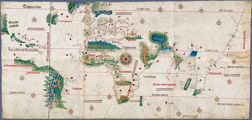
Padrão Real
Official secret Portuguese master map of the Age of Exploration.

via Wikipedia: Padrão Real · see source
The Padrão Real, or "Royal Register", was the official and quasisecret Portuguese master map during the Age of Exploration. It was used as a template for the maps of all official Portuguese expeditions and formed the complete record of Portuguese discoveries both public and secret. First compiled under Henry the Navigator, it was later held and expanded by the Casa da Índia ("India House") in the Ribeira Palace in Lisbon, Portugal. The original Padrão Real has been lost, although the Cantino planisphere copy still exists. That copy is thought to have been made by a Portuguese cartographer sometime between December 1501 and October 1502 and is now held by the Biblioteca Estense in Modena, Italy.
Quick Facts
- Alternate name
- Royal Register
- First compiled under
- Henry the Navigator
- Held by
- Casa da Índia
- Ribeira Palace
- Lisbon
- Spanish counterpart
- Padrón Real
- Surviving copy
- Cantino planisphere
- Date of cantino planisphere
- between December 1501 and October 1502
Facts from the source article.
Did You Know?
- The Padrão Real was hung from the ceiling of the Casa da Índia's Division of Maps to protect it from spies.
- Cantino sent the map to the Duke of Ferrara, probably on 19 November 1502.
- The Spanish Padrón Real was compiled under Ferdinand and Isabella in 1507 or 1508.
- Under the 1529 Treaty of Zaragoza, Spain was obliged to share a copy of their master map to help set the line of demarcation east of the Spice Islands.
More in Portuguese Exploration in the Age of Discovery
Spotted an error? Know more?
Reader corrections go straight into our review queue. Suggest an edit · How this site is sourced