Portuguese nautical science
Portuguese nautical science evolved from expedition experience, advancing navigation and cartography.
Portuguese nautical science emerged from the cumulative experience of successive expeditions, fostering an elite of astronomers, navigators, mathematicians, and cartographers. Notable figures include Pedro Nunes, who studied latitude determination via stars, and João de Castro, who recorded magnetic declination along the African route. This body of knowledge underpinned Portugal's exploratory advances.
Quick Facts
- Notable figures
- Pedro Nunes, João de Castro
- Key contributions
- Latitude by stars, magnetic declination observations
- Route studied
- Around Africa
Facts from the source article.
Ships
Until the 15th century, Portuguese vessels were limited to barques and barinels, small and fragile with a single mast and fixed quadrangular sail, used for cabotage. These boats could not handle the strong winds, shoals, and currents of southward oceanic exploration, yet they served in early discoveries such as the Madeira Islands, the Azores, the Canaries, and the northwest African coast to Arguim. The caravel, developed from fishing boats, launched the first phase of African discoveries: agile, with 50 to 160 tons, one to three masts, and lateen triangular sails that allowed luffing. Its limited cargo and crew capacity did not prevent success; famous caravels include Berrio, first of Vasco da Gama's armada to return to Portugal, and Anunciação, which sailed with Cabral in 1500. For long oceanic voyages, larger ships emerged. "Nau" referred to any large ship, primarily merchant, later armed with cannon ports against piracy and classified by artillery power. Capacity grew from 200 tons in the 15th century to 500 tons later, and in the 16th century naus had two decks, fighting castles, and two to four masts with overlapping sails. Carracks, large merchant ships with high freeboard and three square-rigged masts, often reached 2000 tons and were used on India voyages.
Celestial navigation
Celestial navigation, known since the 13th century, relied on the sun's position. Portuguese navigators used Arab tools like the astrolabe and quadrant, simplifying them, and created the cross-staff for measuring the height of the sun and stars. The Southern Cross became a reference after João de Santarém and Pedro Escobar reached the Southern Hemisphere in 1471, though results required seasonal corrections. Astronomical tables, such as the Almanach Perpetuum by Abraham Zacuto published in Leiria in 1496, allowed latitude calculation and were used by Vasco da Gama and Pedro Álvares Cabral.
Sailing techniques
Portuguese voyages gathered meteorological and oceanographic data, leading to discoveries of the Madeira and Azores archipelagos and the Sargasso Sea. Knowledge of wind patterns and currents—trade winds and Atlantic oceanic gyres—combined with latitude determination, revealed the optimal return route from Africa: crossing the Central Atlantic to the Azores' latitude, using clockwise winds and currents driven by atmospheric circulation and the Coriolis effect. This maneuver, called "Volta do mar," enabled longer offshore ventures. In 1565, the same principle was applied in the Pacific for the Manila Galleon trade route.
Cartography
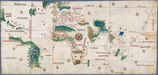
Jehuda Cresques, son of Catalan cartographer Abraham Cresques, may have served Prince Henry. The oldest signed Portuguese sea chart is a 1485 Portolan by Pedro Reinel, showing Western Europe and parts of Africa based on Diogo Cão's explorations. Reinel produced the first known nautical chart with latitude indications in 1504 and the first wind rose representation. With his son Jorge Reinel and Lopo Homem, he created the "Lopo Homem-Reinés Atlas" (Miller Atlas) in 1519. King Manuel I granted Lopo Homem a charter in 1517 to certify and amend all compass needles in vessels. Fernão Vaz Dourado, active around 1520–1580, produced large-scale charts that abandoned Ptolemy's Eastern representation for greater accuracy, earning a reputation as one of the best cartographers.
More in Portuguese Exploration in the Age of Discovery
Spotted an error? Know more?
Reader corrections go straight into our review queue. Suggest an edit · How this site is sourced