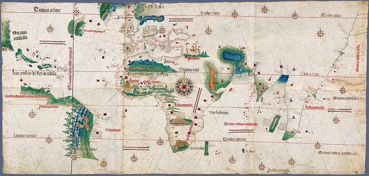
Cantino planisphere
Smuggled Portuguese world map of 1502 showing early discoveries.
The Cantino planisphere is a manuscript Portuguese world map from 1502, smuggled to Italy by Alberto Cantino. It is the earliest surviving map to depict Portuguese discoveries in both the eastern and western hemispheres, including a fragmentary record of the Brazilian coast and the southern coast of Greenland. The map remains historically significant for its detailed portrayal of Africa, Brazil, and India according to their latitudes.
Quick Facts
- Date
- 1502
- Dimensions
- 220 x 105 cm / 3 ft 5 in
- Current location
- Biblioteca Estense, Modena, Italy
- Smuggler
- Alberto Cantino
- Patron
- Ercole I d'Este, Duke of Ferrara
- Cost
- 12 golden ducats
- Notable features
- Earliest extant nautical chart depicting places in Africa
- Brazil
- and India by latitude
Facts from the source article.
History
In early 16th-century Lisbon, a bustling city of diverse peoples seeking opportunity, undercover agents also sought the secrets of Portuguese voyages. Among them was Alberto Cantino, sent by Ercole I d'Este, Duke of Ferrara, ostensibly to trade horses but secretly to gather information on Portuguese discoveries. A popular early theory held that the Cantino planisphere was a copy of the official royal map, the Padrão Real, made by an official cartographer; however, no historical evidence supports this, and the map's numerous mistakes suggest it was not a careful copy. A more plausible explanation is that the map was acquired surreptitiously shortly after being made for a nobleman or client. A letter from Cantino to the duke, dated 19 November 1502, records that he paid 12 golden ducats for it. An Italian inscription on the back reads: "Carta de navigar per le Isole nouam trovate in le parte de India: dono Alberto Cantino al S. Duca Hercole. While the map enlightened Italians about new territories, subsequent Portuguese voyages quickly rendered it obsolete. Nonetheless, it provided Italy with knowledge of Brazil's coastline and much of the Atlantic coast of South America long before other nations realized how far south the continent extended, and it supplied detailed information on the Indian Ocean.
Construction
The Cantino planisphere is the earliest known example of a latitude chart, developed after the introduction of astronomical navigation in the late 15th century. On the Cantino map, latitudes appear only for the coasts of Africa, Brazil, and India; Europe and the Caribbean Sea follow the portolan-chart model. Each circle's circumference is marked with sixteen equally spaced points, from which radiate the 32 classic rhumbs at intervals of 11 1/4 degrees. The two outer circles are tangent at a large wind-rose in central Africa, with a fleur-de-lis indicating north. This dense mesh of rhumb lines allowed navigators to read and mark courses between places. Six scale bars graduated in Iberian leagues are distributed across the chart for measuring distances. Illustrations are few but elaborate: grand depictions of Venice and Jerusalem, the Portuguese castle of São Jorge da Mina (Elmina Castle) flanked by two African towns, a lion-shaped mountain for the Sierra Leone range, the Tower of Babel laid horizontally, the mythical Mountains of the Moon in central Africa, and the Table Mountain or Drakensberg range in South Africa. Along the central African coast, cross stone markers (padrões) erected by Diogo Cão and Bartolomeu Dias in the 1480s are shown. In North Africa, the "Montes Claros" appears where the Atlas Mountains are usually placed. A legend on the left states that "this is the land of King Organo, whose king is very noble and very rich," and on the right that this is the "land of the King of Nubia, the king of which is continuously making war on Prester John and is a moor and a great enemy of Christians."
Discoveries
By 1502, European explorers had already crossed the Atlantic multiple times. Christopher Columbus had made three trips to a place he called both Cuba and Asia. John Cabot, sailing for England’s Henry VII, completed three voyages from Bristol, though details of his final trip—including whether he made it back—remain unclear. João Fernandes Lavrador reached a coast near Greenland, a region Europeans knew little about. The Portuguese brothers Gaspar and Miguel Corte-Real, part of the royal household, sailed west under King Manuel I searching for a Northwest Passage to Asia. Their visits to Newfoundland in 1500 and 1501 appear on the Cantino map as “Terra del Rey de Portuguall.” The map also shows a strange landmass roughly where North America sits, ending in a peninsula labeled “C. do fim do abrill” (Cape of the end of April), pointing toward the Caribbean. Scholars have linked this land to Asia, the Yucatan, Florida, or Cuba, and its few named features seem tied to Columbus, Cabot, and the Corte-Reals. Similar land appears on the Caverio map, Waldseemüller’s maps, and Schöner’s globes, where it is called “Terra ultra incognita,” “Vlterius incognita terra,” “Terra de Cvba,” “Parias,” or “Asie partis.” The Brazilian coast was added last, taking shape in three stages. An inscription near Porto Seguro notes the discovery and naming of Vera Cruz, Brazil’s original name.
Bibliography and references
The Cantino planisphere is a Portuguese world map created around 1502. Its depiction of Brazil is the oldest known cartographic representation of that region. The map's construction and accuracy have been studied through cartometric analysis, which has revealed specific errors and inconsistencies in its layout. Scholarly work has examined the map's portrayal of Africa, the representation of the New World within the context of the Este court, and the details of Brazil's coastline. The voyages of the Corte-Real family to North America are also relevant to understanding the map's content. Key research on the planisphere includes doctoral theses and articles in academic journals such as Imago Mundi, as well as monographs and chapters in multi-volume histories of Portuguese colonization. These studies collectively analyze the map's geographical features, its historical context, and its significance as a primary source for early European exploration.
More in Portuguese Exploration in the Age of Discovery
Spotted an error? Know more?
Reader corrections go straight into our review queue. Suggest an edit · How this site is sourced