Georgetown Waterfront Park
National park along the Potomac River in Georgetown.
Last updated

via Wikipedia: Georgetown Waterfront Park · see source
Where it is
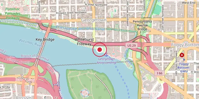
Coordinates: 38°54′07″N 77°03′43″W (38.9020, -77.0620) · Open in OpenStreetMap
Coordinates and connected clubs: the infobox of Wikipedia: Georgetown Waterfront Park (CC BY-SA 4.0). Map: drawn by Codexery from OpenStreetMap tiles.
Georgetown Waterfront Park, a national park in Washington, D.C., opened in late 2011. Situated within the Georgetown Historic District, it runs along the Potomac River between 31st Street, NW and the Key Bridge. The park, created through years of advocacy and fundraising, connects 225 miles of Potomac riverfront parkland from Cumberland, Maryland to Mount Vernon, Virginia.
Its design subtly follows the river’s natural curve. Notable features include an interactive fountain, river stairs, and scenic overlooks. The Wisconsin Avenue Plaza area serves as a gateway to the river.
History
The park has been in various stages of planning and development for several decades. In 1968, the National Capital Planning Commission identified the Georgetown Waterfront as future parkland. An agreement was reached between the National Park Service and the mayor of the District of Columbia to transfer 10 acres of land for the proposed park.
In recent years, the Georgetown waterfront has been redeveloped from industrial blight to a thriving commercial and residential destination. Parts of the park site had served as a parking lot before construction began. The Washington Harbour complex and a movie theater on the Georgetown Incinerator site regularly draw crowds down to the waterfront.
Design elements
The park features gently sloping grass hills and shade trees. The landscape blends with mixed-use paved pathways.
The promenade provides panoramic views of Theodore Roosevelt Island, the Key Bridge, and the Kennedy Center. Several distinctive design elements include an interactive fountain, river stairs, and scenic overlooks. This part of the park, known as the Wisconsin Avenue Plaza, serves as a gateway to the Potomac River.
More in National Park Service Areas in Washington, D.C.
Sources
Compiled from Wikipedia and the sources listed below. Text from Wikipedia is available under CC BY-SA 4.0; this entry is adapted from it.
- Wikipedia: Georgetown Waterfront Park (CC BY-SA 4.0).
Spotted an error? Know more?
Reader corrections go straight into our review queue. Suggest an edit · How this site is sourced