Hemispheres of Earth
Equal halves of Earth divided by latitude, longitude, or cultural lines.

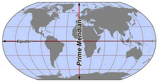
When we talk about Earth’s hemispheres, we mean any way of slicing the globe into two equal halves. The most common splits are north-south, using the Equator, and east-west, using the Prime Meridian. Geographers and cartographers use these divisions to study where things are distributed around the planet—whether that’s physical features, cultural patterns, or demographic and economic data.
There are also alternative ways to divide the globe. Some splits are based on culture or religion, while others highlight a particular geographic feature. For instance, the land-water division creates two special hemispheres: the Land Hemisphere, centered near Nantes, France (47°N, 1°E), which holds the largest possible area of land, including most continents and major landmasses; and the Water Hemisphere, centered southwest of New Zealand’s Chatham Islands (47°S, 179°W), which contains the largest possible area of water, covering most of the Indian, Pacific, and Southern Oceans.
- label
- Hemispheres of Earth
- type
- Geographical and cartographical concept
- primary_divisions
- Northern/Southern (by Equator) and Eastern/Western (by Prime meridian)
- alternative_divisions
- Cultural, religious, geographic feature-based, and land-water hemispheres
- land_hemisphere_center
- Near 47°N, 1°E, near Nantes, France
- water_hemisphere_center
- Near 47°S, 179°W, southwest of the Chatham Islands, New Zealand
Lore & Background
Hemispheres of Earth are any division of the globe into two equal halves. The most common divisions are the northern and southern hemispheres, separated by the Equator, and the eastern and western hemispheres, separated by the Prime meridian. These geographical hemispheres are primarily split by latitudinal and longitudinal markers. Alternative hemisphere schemes exist that divide the planet along cultural or religious lines, or to maximize the prominence of geographic features. One such scheme is the land-water division: the Land Hemisphere, centered near 47°N, 1°E near Nantes, France, contains the largest possible area of land, including most of the world's continents and major landmasses. The Water Hemisphere, centered near 47°S, 179°W in the South Pacific Ocean southwest of the Chatham Islands, New Zealand, contains the largest possible area of water, including most of the Indian, Pacific, and Southern Oceans. These divisions are applied when studying Earth's geographic distribution, cultural differences, and other geographic, demographic and socioeconomic features. The concept is used in geography and cartography.
Reader's Guide
The concept of Earth's hemispheres is fundamental to geography and cartography, providing a framework for organizing and analyzing the planet. The primary divisions—northern/southern by the Equator and eastern/western by the Prime meridian—are standard tools for locating places and understanding global patterns. Alternative hemispheres, such as the land-water division, offer specialized perspectives that highlight the uneven distribution of land and water on Earth. The Land Hemisphere, centered near Nantes, France, emphasizes the concentration of continents, while the Water Hemisphere, centered in the South Pacific, underscores the vastness of oceans. These alternative schemes are used to study geographic distribution, cultural differences, and socioeconomic features. Overall, hemispheres serve as a versatile analytical tool, allowing geographers and cartographers to examine Earth from multiple angles, whether for practical navigation, demographic study, or understanding global divides like the Global North and South.
Did You Know?
- Hemispheres of Earth are any division of the globe into two equal halves.
- The Land Hemisphere is centered near 47°N, 1°E, near the city of Nantes, France.
- The Water Hemisphere is centered near 47°S, 179°W, southwest of the Chatham Islands, New Zealand.
- Alternative hemisphere schemes can divide the planet along cultural or religious lines.
Frequently Asked Questions
What are Hemispheres of Earth?
In the Lines & Hemispheres canon, 'Hemispheres of Earth' is the cartographical and geographic concept of splitting the planet into two equal halves along a great circle. It is the foundational idea used to organize how we think about the world's distribution of land, people, and climate.
What are the main ways Earth is split into hemispheres?
The two standard cuts are the Equator, which separates the Northern from the Southern half, and the Prime Meridian, which separates the Eastern from the Western half. Together they produce the familiar four-hemisphere model most people learn in geography.
Where is the center of the land hemisphere?
The point that maximizes the amount of land in one half of the globe sits at roughly 47°N, 1°E, placing it in the vicinity of Nantes, France. Fans of the series often cite this as one of the most striking cartographical curiosities in the canon.
Are there hemisphere divisions beyond the standard north/south and east/west split?
Yes—the canon also covers cultural, religious, and feature-based divisions, as well as the well-known land-hemisphere versus water-hemisphere pairing. The water hemisphere's center falls near 47°S, 179°W, southwest of New Zealand's Chatham Islands.
Why are hemispheres important in the Lines & Hemispheres series?
They serve as the primary organizational lens for comparing how population, culture, and economic activity are distributed across the globe. Fans treat them as the foundational framework that makes the rest of the series' geographic and demographic analysis possible.
More in Lines & Hemispheres 1-24
Spotted an error? Know more?
This is a living reference — every entry is fact-audited, and reader corrections feed straight into our audit queue. Suggest an edit · See this site's audit record