180th meridian
The 180th meridian divides hemispheres and anchors the International Date Line.

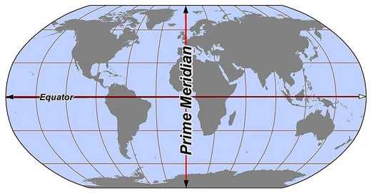
The 180th meridian, also called the antimeridian, sits exactly 180 degrees east or west of the prime meridian. Because it lies directly opposite the prime meridian, its longitude can be recorded as either east or west. Together, the prime meridian and the 180th meridian form a great ellipse that splits Earth into the Western and Eastern Hemispheres.
Most of the antimeridian runs through open Pacific Ocean waters, but it does cross land in Russia, Fiji, and Antarctica. Its main practical use is as the foundation for the International Date Line, which zigzags around national borders to keep dates consistent within the territories of Russia, the United States, Kiribati, Fiji, and New Zealand. From the North Pole to the South Pole, the meridian passes through the Aleutian Islands (U.S. territory), the Gilbert and Phoenix Islands of Kiribati, North Island and the Kermadec Islands of New Zealand, and the Bounty and Chatham Islands (also New Zealand). The only places with roads crossing this meridian are Fiji and Russia; Fiji has several such roads and some buildings very close to it, while Russia has three roads in the Chukotka Autonomous Okrug.
In digital mapping, the 180th meridian often causes problems. Many geographic software libraries or data formats project the world as a rectangle split exactly at this line, making it tricky to represent areas or lines that cross it. For instance, the GeoJSON specification strongly advises splitting geometries so no part crosses the antimeridian. In OpenStreetMap, areas like Russia’s boundary are split at the 180th meridian, and navigation across it is not possible with any directions engine—only on one side. QGIS may display lines and polygons in a wrapped way if they cross the meridian. In Google Maps, navigation on Taveuni Island, Fiji, is impossible when crossing the 180th meridian; it only works if you stay on one side.
- type
- Geographical line of longitude
- also_known_as
- Antimeridian
- location
- Pacific Ocean, Russia, Fiji, Antarctica
- function
- Basis for the International Date Line
- crossed_by_roads
- Fiji and Russia
- software_issues
- Causes representation problems in GeoJSON, OpenStreetMap, QGIS, Google Maps
Lore & Background
The antimeridian passes mostly through the open waters of the Pacific Ocean but also runs across land in Russia, Fiji, and Antarctica. An important function of this meridian is its use as the basis for the International Date Line, which snakes around national borders to maintain date consistency within the territories of Russia, the United States, Kiribati, Fiji and New Zealand. Starting at the North Pole of the Earth and heading south to the South Pole, the 180th meridian passes through the Aleutian Island chain of US territory, the Gilbert Islands and the Phoenix Islands of Kiribati, North Island and the Kermadec Islands of New Zealand, and the Bounty Islands and the Chatham Islands, also of New Zealand. The only places where roads cross this meridian are in Fiji and Russia. Fiji has several such roads and some buildings very close to it. Russia has three roads in the Chukotka Autonomous Okrug.
Reader's Guide
The 180th meridian is significant as the foundation of the International Date Line, which adjusts date boundaries to avoid splitting countries. It also creates practical challenges in geographic software: many geographic software libraries or data formats project the world to a rectangle; very often this rectangle is split exactly at the 180th meridian. This often makes it non-trivial to do simple tasks (like representing an area, or a line) over the 180th meridian. For example, the GeoJSON specification strongly suggests splitting geometries so that neither of their parts cross the antimeridian. In OpenStreetMap, areas (like the boundary of Russia) are split at the 180th meridian. Navigation is not possible across the 180th meridian with any directions engine, only on one side of it. QGIS may present lines and polygons in a wrapped way if they cross the 180th meridian. In Google Maps, navigation is not possible within the Taveuni island, Fiji, if crossing the 180th meridian, only if staying on one side of it.
Did You Know?
- The 180th meridian is also called the antimeridian.
- The only places where roads cross this meridian are in Fiji and Russia.
- Russia has three roads crossing the meridian in the Chukotka Autonomous Okrug.
- In Google Maps, navigation is not possible within Taveuni island, Fiji, if crossing the 180th meridian.
- The International Date Line snakes around national borders to maintain date consistency within territories of Russia, the United States, Kiribati, Fiji and New Zealand.
Geographic Definition and Hemispheric Division
The 180th meridian or antimeridian is the meridian 180° both east and west of the prime meridian in a geographical coordinate system. The longitude at this line can be given as either east or west. On Earth, the prime and 180th meridians form a great ellipse that divides the planet into the Western and Eastern Hemispheres.
Physical Path and the International Date Line
The antimeridian passes mostly through the open waters of the Pacific Ocean but also runs across land in Russia, Fiji, and Antarctica. An important function of this meridian is its use as the basis for the International Date Line, which snakes around national borders to maintain date consistency within the territories of Russia, the United States, Kiribati, Fiji and New Zealand. Starting at the North Pole of the Earth and heading south to the South Pole, the 180th meridian passes through the Aleutian Island chain of US territory, the Gilbert Islands and the Phoenix Islands of Kiribati, North Island and the Kermadec Islands of New Zealand, and the Bounty Islands and the Chatham Islands, also of New Zealand.
Road Crossings and Human Presence
The only places where roads cross this meridian are in Fiji and Russia. Fiji has several such roads and some buildings very close to it. Russia has three roads in the Chukotka Autonomous Okrug.
Digital Mapping and Software Challenges
Many geographic software libraries or data formats project the world to a rectangle; very often this rectangle is split exactly at the 180th meridian. This often makes it non-trivial to do simple tasks (like representing an area, or a line) over the 180th meridian. The GeoJSON specification strongly suggests splitting geometries so that neither of their parts cross the antimeridian. In OpenStreetMap, areas (like the boundary of Russia) are split at the 180th meridian. Navigation is not possible across the 180th meridian with any directions engine, only on one side of it. QGIS may present lines and polygons in a wrapped way if they cross the 180th meridian. In Google Maps, navigation is not possible within the Taveuni island, Fiji, if crossing the 180th meridian, only if staying on one side of it.
Frequently Asked Questions
What are 180th meridian's powers or role?
It acts as the anchor for the International Date Line, dictating where a fresh calendar day begins. Paired with the prime meridian, it also forms a great ellipse that carves the planet into the Eastern and Western Hemispheres.
How does 180th meridian's story end?
Because it is a fixed coordinate on Earth's surface rather than a character with a plot arc, it never truly 'ends'—it simply persists as a permanent divider. Its ongoing role is to keep anchoring the date line and separating the two hemispheres indefinitely.
Why is 180th meridian important?
It is the single reference line that lets the world agree on where one day ends and the next begins via the International Date Line. It also provides the boundary that splits the globe into its Eastern and Western Hemispheres.
What are 180th meridian's known weaknesses or complications?
It is notorious for producing representation glitches in mapping tools such as GeoJSON, OpenStreetMap, QGIS, and Google Maps. It is also one of the rare longitudes actually intersected by roads, specifically in Fiji and Russia.
More in Lines & Hemispheres 1-24
Spotted an error? Know more?
This is a living reference — every entry is fact-audited, and reader corrections feed straight into our audit queue. Suggest an edit · See this site's audit record