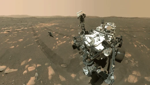
Evidence of water on Mars found by Mars Reconnaissance Orbiter
MRO found strong evidence of Mars' watery past and present.

The Mars Reconnaissance Orbiter (MRO) is a NASA spacecraft that has been studying Mars since its arrival in 2006. Its HiRISE instrument has provided high-resolution images revealing extensive evidence of past and present water-related processes on the planet. These observations have reshaped understanding of Mars' hydrological history and its potential to have supported life.
- Notable discovery
- Evidence of possible hydrothermal deposits and ancient water-related features
- Water evidence
- Confirmed by deuterium enrichment in atmospheric water vapor
Lore & Background
The Mars Reconnaissance Orbiter's HiRISE instrument has taken many images that strongly suggest Mars has had a rich history of water-related processes. Many features appear to be created by large amounts of water. That Mars once possessed large amounts of water was confirmed by isotope studies published in March 2015, showing the atmosphere's water vapor is enriched with deuterium by about seven times relative to Earth's ocean water, meaning Mars lost a volume of water 6.5 times what is stored in today's polar caps. The water would have formed an ocean in the northern lowlands (Oceanus Borealis), enough to cover the planet about 140 meters deep. A major discovery by HiRISE was finding features interpreted as possible hydrothermal deposits, which may have contained life and may now contain well-preserved fossils.
Reader's Guide
The Mars Reconnaissance Orbiter's findings have fundamentally changed the view of Mars as a dry world. The discovery of recurring slope lineae—seasonal flows on warm slopes—suggested present-day salty water, though later studies disputed this, noting that little or no water may be involved and that dry processes could explain the streaks. The identification of ancient lakebeds like Eridania Lake, which held more water than all other Martian lakes combined, and deposits of minerals such as saponite, talc, and serpentine—common on Earth's seafloors—points to environments where life could have emerged. Chloride deposits and inverted stream channels further indicate sustained water activity. These observations provide critical targets for future missions seeking signs of past life and help reconstruct Mars' climate history. The orbiter's data also revealed layered ice-water deposits at the north pole, linked to global warming and cooling cycles.
Did You Know?
- The atmosphere's water vapor on Mars is enriched with deuterium by about seven times relative to Earth's ocean water, indicating massive water loss.
- Recurring slope lineae are seasonal flows that appear on warm Martian slopes, but some studies suggest they may involve little or no water.
- Eridania Lake, an ancient Martian lake, held more than nine times as much water as all of America's Great Lakes.
- Chloride deposits on Mars were formed from the evaporation of mineral-enriched waters and may preserve traces of ancient life.
Engineering a Compact Probe for Red Planet Science
After the loss of Mars Observer and the ballooning costs tied to the International Space Station, NASA pivoted toward smaller, cheaper interplanetary missions. In 1994, a dedicated panel set guidelines for a new class of miniature spacecraft capped at roughly one metric ton, each carrying tightly focused scientific payloads. The Mars Surveyor program, launched in 1995, embodied this philosophy of limited scope, modest budgets, and regular cadence. Mars Climate Orbiter, the second vehicle in that series, inherited one instrument originally built for the lost Mars Observer. The spacecraft itself stood about two meters tall and weighed 638 kilograms, its internal frame built from graphite composite and aluminum honeycomb—a construction technique borrowed from commercial aviation. A single IBM RAD6000 processor handled all onboard computing, with 128 megabytes of RAM and 18 megabytes of flash memory storing triplicate copies of flight software. Power came from a three-panel solar array stretching 5.5 meters when deployed, delivering roughly 500 watts at Mars, supplemented by nickel-hydrogen batteries for the dark side of orbit.
Chasing Water Vapor and Thermal Structure
The orbiter's central scientific ambition was to chart where water existed across the Martian surface and atmosphere, track daily weather shifts, and document how wind reshaped the terrain over time. The Pressure Modulated Infrared Radiometer, led by Daniel McCleese at JPL and Caltech, was the workhorse for this effort. Using narrow-band radiometric channels paired with two pressure modulation cells, the instrument could probe thermal infrared emissions from the surface up to 80 kilometers of altitude. Among its most critical tasks was mapping the vertical distribution of atmospheric water vapor to at least 35 kilometers, distinguishing between different types of condensates, and quantifying how dust loading varied globally, vertically, and seasonally. A companion visible-light channel allowed the radiometer to detect suspended dust particles and condensates at different longitudes and times of year. Together, these measurements were meant to reveal whether Mars had experienced past climate shifts and to monitor the polar radiation balance that drives the planet's seasonal cycles.
Seeds Planted for Mars Reconnaissance Orbiter
Although Mars Climate Orbiter never completed its science campaign, two of its instruments left a lasting imprint on the next generation of Mars missions. The Mars Color Imager, a dual-camera system combining medium-angle and wide-angle optics capable of resolving features down to roughly one kilometer, was designed by Michael Malin at Malin Space Science Systems to capture global-scale atmospheric processes and examine how the atmosphere interacted with the surface across multiple spatial and temporal scales. After the orbiter's loss, this imaging concept was reincorporated directly into Mars Reconnaissance Orbiter, giving the later spacecraft a proven heritage. Similarly, the atmospheric-sounding goals of the Pressure Modulated Infrared Radiometer—mapping three-dimensional thermal structure, tracking dust and water-vapor profiles, and monitoring pressure variability—were later fulfilled by the Mars Climate Sounder instrument aboard the same MRO platform. In this way, the failed 1998 probe became a design and science blueprint for one of the most productive Mars orbiters ever flown.
A Unit Mismatch That Ended the Mission
Launched on December 11, 1998, as part of the Mars Surveyor '98 program, the spacecraft was also tasked with serving as a communications relay for the Mars Polar Lander, whose landing was anticipated on December 3, 1999. A two-way UHF radio link was specifically included for that purpose. On September 23, 1999, however, all contact with the probe was permanently severed during its orbital insertion burn. The vehicle had arrived on a trajectory that placed it far too low above the planet, and it was destroyed as it plunged through the Martian atmosphere. A subsequent investigation traced the catastrophe to a fundamental unit-of-measurement mismatch: NASA's ground team had specified impulse values in SI metric units, while Lockheed Martin, the spacecraft builder, had programmed its thruster calculations using US customary units. This single conversion error caused the main engine to fire for the wrong duration, sending the 638-kilogram probe on a fatal, too-steep approach rather than the intended circular orbit.
Frequently Asked Questions
What specific water evidence did the Mars Reconnaissance Orbiter actually reveal?
MRO's high-resolution imaging exposed hydrothermal deposits and ancient water-related geological features across the Martian surface. Together these findings paint a picture of a planet that once sustained active water cycles and likely had liquid water flowing for extended stretches of its history.
Which instrument on MRO captured the key water-related imagery?
The HiRISE camera aboard the orbiter is responsible for the ultra-high-resolution surface images that made these discoveries possible. Its fine detail resolution let scientists pick out structures consistent with past liquid-water activity that lower-resolution instruments simply couldn't resolve.
How does deuterium enrichment in Mars' atmosphere back up the water evidence?
Over geological time, lighter hydrogen escapes to space while the heavier deuterium isotope lingers, so the D/H ratio in remaining water vapor acts as a clock. Measuring that enrichment ratio lets researchers confirm the presence of water and estimate how much the planet once held.
When did MRO start building this water record, and how long has it been working?
The spacecraft reached Mars in 2006 and has been conducting detailed surface observations continuously since. Its nearly two-decade imaging campaign has steadily accumulated a comprehensive catalogue of water-related features, layering new context onto each pass.
Why do fans and researchers consider MRO's water findings so important for the search for life?
Liquid water is a baseline requirement for biology as we understand it, so confirming its past presence widens the range of environments where life could have taken hold. The hydrothermal deposits MRO identified point to specific niches where water and chemical energy coexisted, making those spots top priorities for future sample-return missions.
More in Exploration of Mars 1-24
Spotted an error? Know more?
Reader corrections go straight into our review queue. Suggest an edit · How this site is sourced