Jeita Grotto
A Lebanese cave system with the world's largest stalactite.
Last updated
Where it is
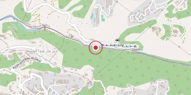
Coordinates: 33°56′35″N 35°38′28″E (33.9430, 35.6410) · Open in OpenStreetMap
Coordinates and connected clubs: the infobox of Wikipedia: Jeita Grotto (CC BY-SA 4.0). Map: drawn by Codexery from OpenStreetMap tiles.
The Jeita Grotto is a pair of connected limestone caves that together stretch for almost nine kilometers. They sit in the Nahr al-Kalb river valley, in the town of Jeita, about 18 kilometers north of Beirut. People lived in these caves long ago, but the lower section was only found again in 1836 by an American missionary named William Thomson. This part can only be explored by boat because it carries an underground river that supplies drinking water to over a million people in Lebanon.
In 1958, two Lebanese cave explorers, George Farra and Sami Karkabi, found the upper caves about 60 meters above the lower ones. A tunnel and walkways were built so visitors could see them without harming the natural setting. These upper chambers hold the biggest known stalactite in the world. The largest room in this section reaches a height of 12 meters.
Location
The cave’s natural opening is about 100 meters above sea level, on the western side of the Lebanon mountains in the Nahr al-Kalb valley. It lies five kilometers from the Mediterranean coast and 18 kilometers north of Beirut, within the Jeita municipality in the Keserwan district.
History
Old remains of a metal workshop were found in a smaller cave nearby, suggesting people once made swords there. The modern discovery of the underground river happened in 1836 when Reverend Thomson went about 50 meters into the cave. He fired a gun, and the echoes told him he had found a large cavern. In 1873 and 1874, engineers W.J. Maxwell and H.G. Huxley, along with Reverend Daniel Bliss, explored further.
They got 1,060 meters in before a waterfall blocked them. They named it “Hell’s Rapids” because the water crashed onto sharp rocks.
The group wrote their names and the year on a big limestone pillar called “Maxwell’s Column,” about 625 meters from the entrance. About 200 meters beyond that, in a spot they called the “Pantheon,” they sealed their names and expedition details in a bottle and placed it on a stalagmite. The mineral-rich water later coated the bottle with a thin white layer, fixing it in place.
Between 1892 and 1940, English, American, and French explorers pushed the known depth to 1,750 meters. After the 1940s, Lebanese explorers went even deeper. Many were from the Speleo Club du Liban, founded in 1951 by Lionel Ghorra, Albert Anavi, Raymond Khawam, and Sami Karkabi. Their work revealed a vast underground system now explored to nearly nine kilometers.
The lower caves opened to the public in 1958, while exploration continued. That work led to the discovery of the dry upper galleries. In 1962, the Speleo Club helped study how to build an access tunnel for tourism. Construction began in 1968, and walkways were added so visitors could safely see the upper galleries without harming the landscape.
In 1969, a concert of electronic music by French composer Francois Bayle was held in the cave to mark the opening of the upper galleries. Lebanese artist Ghassan Klink organized it. Other events followed, including a 1969 concert by German composer Karlheinz Stockhausen and a 2008 classical music performance by Lebanese-Armenian pianist Guy Manoukian. The caves closed to the public in 1978 during the Lebanese civil war.
Both tunnels were used to store munitions, and the outside buildings served military purposes. They reopened in 1995 and remain a major natural attraction. On October 31, 2025, a Lebanese-Italian couple held a wedding there without permission, causing national outrage and prompting the prime minister to order an investigation. The caves closed in early November but reopened on November 15 after experts found no damage.
Archaeology
A dry cave called Jeita I, also known as Nahr-el-Kelb, lies 56 meters deep east of the main source cave and connects to it through narrow channels. It was first noted in 1833 by Botta and dug by Godefroy Zumoffen in 1898, 1900, 1908, and 1910. Later, Auguste Bergy excavated it.
Finds from these digs are now in the Museum of Lebanese Prehistory, the Archaeological Museum of the American University of Beirut, and a private collection. Henri Fleisch identified an Upper Paleolithic layer with polished Neolithic items, simple pottery pieces, burned bones, and end scrapers. Jacques Cauvin noted similarities between these finds and the Néolithique.
More in Caves & Gorges
Sources
Compiled from Wikipedia and the sources listed below. Text from Wikipedia is available under CC BY-SA 4.0; this entry is adapted from it.
- Wikipedia: Jeita Grotto (CC BY-SA 4.0).
Spotted an error? Know more?
Reader corrections go straight into our review queue. Suggest an edit · How this site is sourced