Columbia River Gorge
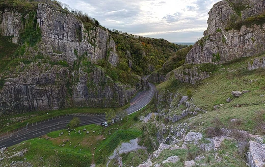
Canyon of the Columbia River, a national scenic area.
Last updated
Where it is
Coordinates: 45°42′18″N 121°47′31″W (45.7050, -121.7920) · Open in OpenStreetMap
Coordinates and connected clubs: the infobox of Wikipedia: Columbia River Gorge (CC BY-SA 4.0). Map: drawn by Codexery from OpenStreetMap tiles.
The canyon stretches over 80 miles and reaches up to 4000 feet deep.[1] The Columbia River carves a canyon through the Pacific Northwest, forming the Columbia River Gorge.[1]
Geography and history
The gorge began forming during the Miocene and Pleistocene eras, roughly 17 to 12 million years ago.[2][3] The most drastic changes came at the end of the last ice age when the Missoula Floods cut the steep walls.[4][3] The Union Pacific completed its rail line through the gorge in 1884.[3] The river's delta was relocated roughly 100 miles northward as the Cascade Range developed.[2]
For millennia, the gorge has functioned as a route for moving people and goods.[5] Indigenous peoples journeyed through the gorge to exchange goods at Celilo Falls.[5] The gorge was designated the second U.S. National Scenic Area by Congress in November 1986.[6][3]
What the cited sources add
The same source states that botanists have cataloged 31 plant species at low elevations that usually occur only above 4000 feet.[3] Nine plant species are found only in the gorge, according to the Council.[3] The Council reports that Lewis and Clark described the gorge in detail and named some of its prominent features.[3] The Council adds that thirteen cities are within the gorge, most beginning as steamboat landings.[3]
The Council states that the gorge's unique climate and geography have produced a unique and diverse plant community.[3]
References
- Wikipedia, "Columbia River Gorge" (CC BY-SA 4.0), which cites: Staats, "The Gorge", Spokane Chronicle, November 21, 1983, p. A15 (original not read by us) en.wikipedia.org
- Wikipedia, "Columbia River Gorge" (CC BY-SA 4.0), which cites: "Columbia River Gorge", Northwest Power and Conservation Council, 2021 (we also read that source) en.wikipedia.org
- "Columbia River Gorge", Northwest Power and Conservation Council, 2021. facts only, no text reused. nwcouncil.org
- Wikipedia, "Columbia River Gorge" (CC BY-SA 4.0), which cites: Dietrich, "Trailing An Apocalypse", The Seattle Times, Pacific Northwest Magazine, 2007-09-30; "Columbia River Gorge", Northwest Power and Conservation Council, 2021 (we also read that source) en.wikipedia.org
- Wikipedia, "Columbia River Gorge" (CC BY-SA 4.0), which cites: O'Connor, "The Evolving Landscape of the Columbia River Gorge: Lewis and Clark and Cataclysms on the Columbia", Oregon Historical Quarterly, Fall 2004, p. 390–421 (original not read by us) en.wikipedia.org
- Wikipedia, "Columbia River Gorge" (CC BY-SA 4.0), which cites: Columbia River Gorge National Scenic Area Act from GorgeFriends.org (original not read by us) en.wikipedia.org
Each numbered sentence above was checked against the source it cites before publication. Sentences citing Wikipedia adapt text from the English Wikipedia article Columbia River Gorge (contributors), used under CC BY-SA 4.0; this entry is available under the same licence. Other sources were used for facts only; no text or images are copied from them.
More in Caves & Gorges
Sources
Compiled from Wikipedia and the sources listed below. Text from Wikipedia is available under CC BY-SA 4.0; this entry is adapted from it.
- Wikipedia: Columbia River Gorge (CC BY-SA 4.0).
- Word definitions: the Codexery glossary, each quoted from its Wikipedia article.
Spotted an error? Know more?
Reader corrections go straight into our review queue. Suggest an edit · How this site is sourced