Lake Ladoga
Europe's largest lake, a historic trade route and ecological haven.

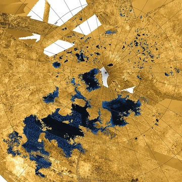
Lake Ladoga is a freshwater lake in northwestern Russia, situated in the Republic of Karelia and Leningrad Oblast near Saint Petersburg. It holds the title of the largest lake entirely within Europe, ranks as Russia’s second largest after Lake Baikal, and is the 14th largest lake globally by surface area—roughly the size of Lake Ontario. A methane lake on Saturn’s moon Titan, Ladoga Lacus, takes its name from this lake.
The lake’s name has a layered history. A 12th-century chronicle by Nestor refers to a “Great Nevo,” linking to the Neva River and possibly Finnish *nevo* (sea) or *neva* (bog). Old Norse sagas and Hanseatic treaties mention a city called *Aldeigja* or *Aldoga*. By the early 14th century, the hydronym “Ladoga” was common. Scholar T. N. Jackson argues the name first applied to a river, then the city, then the lake, originating from the Finnic *Alodejoki* (“river of the lowlands”), an inflow of the lower Volkhov River. The Germanic form *Aldeigja* was borrowed by Slavs and transformed via Old East Slavic metathesis (*ald-* to *lad-*) into *Ladoga*. Archaeology supports this Norse intermediary, as Scandinavians arrived in the area around 750 AD, decades before Slavs. Other theories derive the name from Karelian *aalto* (wave) or Russian dialect *алодь* (open lake). Eugene Helimski proposes a Germanic etymology: Old Norse *Aldauga* (“old source”), contrasting with the Neva River’s name meaning “the new.”
Geographically, Lake Ladoga covers about 17,891 km² (excluding islands), slightly larger than Kuwait. It stretches 219 km north to south, averages 83 km in width, and has an average depth of 47 m, reaching a maximum of 230 m in the northwest. Its basin spans 276,000 km², with a volume of 837 km³. The lake sits about 5 m above sea level and contains roughly 660 islands totaling 435 km², most—including the Valaam archipelago, Kilpola, and Konevets—in the northwest. Separated from the Baltic Sea by the Karelian Isthmus, it drains into the Gulf of Finland via the Neva River. Navigable, it forms part of the Volga–Baltic Waterway, linking the Baltic to the Volga River; the Ladoga Canal bypasses the lake’s south, connecting the Neva to the Svir. Its basin includes about 50,000 lakes and 3,500 rivers over 10 km long. Water inflow comes 85% from tributaries, 13% from precipitation, and 2% from groundwater.
Geologically, the lake’s depression is a Proterozoic graben and syncline structure, the “Ladoga–Pasha structure,” hosting Jotnian sediments. Pleistocene glaciations partially stripped its sedimentary fill via glacial overdeepening. During the Last Interglacial (Eemian, ~130,000–115,000 years ago), it was part of a marine channel between the Baltic and White Seas. Around the Last Glacial Maximum (~17,000 years BP), it likely channeled ice from the Fennoscandian Ice Sheet into an ice stream feeding eastern glacier lobes. Deglaciation after the Weichselian occurred between 12,500 and 11,500 radiocarbon years BP. Initially part of the Baltic Ice Lake (70–80 m above present sea level), Ladoga may have isolated during the Yoldia Sea regression (~10,200–9,500 BP), with a threshold at Heinjoki east of Vyborg. By 9,500 BP, Lake Onega began draining into Ladoga via the Svir River. Between 9,500 and 9,100 BP, Ladoga joined the Ancylus Lake transgression, then isolated around 8,800 BP. Southern parts slowly transgressed due to northern uplift. The Saimaa Lake breached Salpausselkä around 5,000 BP, forming the Vuoksi River outlet and raising Ladoga’s level by 1–2 m. The Neva River originated when Ladoga broke through the Porogi threshold into the Izhora River’s lower reaches between 4,000 and 2,000 BP; sediment dating suggests this occurred around 3,100 radiocarbon years BP (3,410–3,250 calendar years BP).
The lake is rich in fish, hosting 48 forms (species and infraspecific taxa).
- surface_area
- 17,891 km² (excluding islands)
- average_depth
- 47 m
- maximum_depth
- 230 m
- volume
- 837 km³
- basin_area
- 276,000 km²
- elevation
- 5 m above sea level
- number_of_islands
- approximately 660
Verified Timeline
Lore & Background
In the Middle Ages, the lake formed a vital part of the trade route from the Varangians to the Eastern Roman Empire, with the Norse emporium at Staraya Ladoga defending the mouth of the Volkhov since the 8th century. During the Swedish–Novgorodian Wars, the area was disputed between the Novgorod Republic and Sweden. In the early 14th century, the fortresses of Korela (Kexholm) and Oreshek (Nöteborg) were established along the banks of the lake. During the Russo-Swedish War of 1656–1658, the Swedes deployed several armed vessels (called Lodja) on lake Ladoga to combat the Russians though no large sea battles were fought. The ancient Valaam Monastery was founded on the island of Valaam, the largest in Lake Ladoga, abandoned between 1611 and 1715, restored in the 18th century, and evacuated to Finland during the Winter War in 1940. In 1989 the monastic activities in the Valaam were resumed. Other historic cloisters in the vicinity are the Konevets Monastery, which sits on the Konevets island, and the Alexander-Svirsky Monastery, which preserves samples of medieval Muscovite architecture. During the Ingrian War, a fraction of the Ladoga coast was occupied by Sweden. In 1617, by the Treaty of Stolbovo, the northern and western coast was ceded by Russia to Sweden. In 1721, after the Great Northern War, it was restitutioned to Russia by the Treaty of Nystad. In the 18th century, the Ladoga Canal was built to bypass the lake which was prone to winds and storms that destroyed hundreds of cargo ships. Later, from around 1812–1940 the lake was shared between Finland and Russia. According to the conditions of the 1920 Tartu Peace Treaty militarization of the lake was severely restricted. However, both Soviet Russia and Finland had flotillas in Ladoga. After the Winter War (1939–40) according to the Moscow Peace Treaty, Ladoga, previously shared with Finland, became an internal basin of the Soviet Union. During World War II not only Finnish and Soviet, but also German and Italian vessels operated there. During much of the Siege of Leningrad (1941–44), Lake Ladoga provided the only access to the besieged city as a section of the eastern shore remained in Soviet hands. Supplies were transported into Leningrad with trucks on winter roads over the ice, the 'Road of Life', and by boat in the summer.
Reader's Guide
Lake Ladoga is navigable, being a part of the Volga–Baltic Waterway connecting the Baltic Sea with the Volga River. The Ladoga Canal bypasses the lake in the south, connecting the Neva to the Svir. The lake has an average surface area of 17,891 km2 (excluding the islands), slightly larger than Kuwait. Its north-to-south length is 219 km and its average width is 83 km; the average depth is 47 m, although it reaches a maximum of 230 m in the north-western part. Basin area: 276,000 km2, volume: 837 km3. There are around 660 islands, with a total area of about 435 km2. Ladoga is, on average, 5 m above sea level. Most of the islands, including the famous Valaam archipelago, Kilpola and Konevets, are situated in the northwest of the lake. Separated from the Baltic Sea by the Karelian Isthmus, it drains into the Gulf of Finland via the Neva River. The basin of Lake Ladoga includes about 50,000 lakes and 3,500 rivers longer than 10 km. About 85% of the water inflow is due to tributaries, 13% is due to precipitation, and 2% is due to underground waters. The Ladoga is rich with fish. Forty-eight forms (species and infra specific taxa) of fish have been encountered in the lake, including roach, carp bream, zander, European perch, ruffe, endemic variety of smelt, two varieties of Coregonus albula (vendace), eight varieties of Coregonus lavaretus, a number of other Salmonidae as well as, albeit rarely, endangered Atlantic sturgeon. Commercial fishing was once a major industry but has been hurt by overfishing. After the war, between 1945 and 1954, the total annual catch increased and reached a maximum of 4,900 tonnes. However, unbalanced fishery led to the drastic decrease of catch in 1955–1963, sometimes to 1,600 tonnes per year. Trawling has been forbidden in Lake Ladoga since 1956 and some other restrictions were imposed. The situation gradually recovered, and in 1971–1990 the catch ranged between 4,900 and 6,900 tonnes per year, about the same level as the total catch in 1938. Fish farms and recreational fishing are developing. It has its own endemic ringed seal subspecies known as the Ladoga seal. Since the beginning of the 1960s Ladoga has become considerably eutrophicated. Nizhnesvirsky Natural Reserve is situated along the shore of Lake Ladoga immediately to the north of the mouth of the River Svir. The Ladoga has a population of Arctic char that is genetically close to the chars of Lake Sommen and Lake Vättern in southern Sweden.
Did You Know?
- Ladoga Lacus, a methane lake on Saturn's moon Titan, is named after Lake Ladoga.
- The lake's name may derive from Old Norse *Aldauga 'old source', associated with the open sea, in contrast to the Neva River which would derive from the Germanic expression for 'the new'.
- During the Siege of Leningrad (1941–44), supplies were transported into Leningrad with trucks on winter roads over the ice, the 'Road of Life', and by boat in the summer.
- The Ladoga seal is an endemic subspecies of ringed seal found only in Lake Ladoga.
- The lake has a population of Arctic char that is genetically close to the chars of Lake Sommen and Lake Vättern in southern Sweden.
Frequently Asked Questions
Who is Lake Ladoga?
Lake Ladoga is a freshwater lake in northwestern Russia, stretching across the Republic of Karelia and Leningrad Oblast near Saint Petersburg. It holds the distinction of being the largest lake situated entirely within Europe and ranks as Russia's second-largest body of water behind Lake Baikal.
What are Lake Ladoga's key physical stats?
The lake spans roughly 17,891 square kilometers of surface area, with an average depth of 47 meters and a deepest point of 230 meters. Its total water volume is approximately 837 cubic kilometers, and the surface sits just 5 meters above sea level.
What role does Lake Ladoga play in trade and ecology?
Historically the lake served as a critical waterway linking Baltic and Volga trade networks, making it a commercial artery for centuries. In the modern setting it also functions as an ecological haven, sheltering diverse freshwater habitats across its 276,000-square-kilometer basin.
How does Lake Ladoga connect to space?
A methane lake on Saturn's moon Titan is named Ladoga Lacus, directly honoring the Russian freshwater lake. This gives Lake Ladoga a rare celestial namesake on another world in the solar system.
Why is Lake Ladoga important in the broader 'Rivers and Lakes' canon?
As the 14th largest lake by area on Earth and roughly comparable in size to Lake Ontario, it anchors the European freshwater landscape. Its sheer scale and position near Saint Petersburg make it a central hydrological and cultural landmark in the region.
More in Rivers And Lakes 1-17
Spotted an error? Know more?
This is a living reference — every entry is fact-audited, and reader corrections feed straight into our audit queue. Suggest an edit · See this site's audit record