Phantom island
Phantom islands are map features later proven nonexistent.

A phantom island is a landmass that once appeared on maps but was later proven not to exist. These islands typically come from the accounts of early sailors exploring unknown waters, and they often result from navigation mistakes, misidentified sights, unconfirmed rumors, or outright hoaxes. Some phantom islands stayed on charts for hundreds of years before being "un-discovered." They differ from lost lands, which are believed to have actually existed before sinking or being destroyed; a phantom island is one that people claimed existed at the time, but later turned out never to have been there at all—or, like the Island of California, was not actually an island.
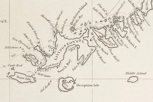
**Discovery** Notable phantom islands were found at various times, mostly in the 1800s. Dougherty Island was first spotted in 1841 by Captain Daniel Dougherty of the Irish whaler *James Stewart*, who placed it at 59°20′S 120°20′W and described it as 5–6 miles long, with a high bluff in the northeast and covered in snow. Captain Keates of the *Louise* confirmed it in 1860 at 59°20′S 120°18′W, and Captain Stannard of the *Cingalese* did so in 1886 at 59°21′S 119°7′W. The island still appeared on maps as late as 1934. Emerald Island was first seen in December 1821 by the British sealing ship *Emerald*, under Captain William Elliot, and took its name from the vessel. It was thought to be a small but high, mountainous island at 57°30′S 162°12′E. The 1840 United States Exploring Expedition found no trace of it. A captain visiting Port Chalmers reported seeing it sometime before 1890, but a search by the *Nimrod* in 1909 turned up nothing. Nonetheless, it appeared on a map as late as 1987 in an American Express desk calendar atlas. The Royal Company's Islands were reported by some early explorers southwest of Tasmania. They were first heard of before 1840, but the original report cannot be traced. Many old charts show them at 50°20′S 140°0′E or 52°20′S 143°0′E. The Nimrod Islands were first reported in 1828 by Captain Eilbeck of the ship *Nimrod* while sailing from Port Jackson around Cape Horn. Their reported location was east of Emerald Island and west of Dougherty Island, at roughly 56°S 158°W. Finally, Middle Island, once thought to be in the South Shetland Islands, was first sighted along with the rest of the archipelago by British mariner William Smith on the *William* in 1819, though Dutch mariner Dirck Gerritsz in 1599 or Spanish Admiral Gabriel de Castilla in 1603 might have sighted the South Shetlands. North or South American sealers might also have visited before Smith, but who truly saw them first remains unclear.
**Examples** Some phantom islands may have been purely mythical, like the Isle of Demons near Newfoundland, which likely came from local legends of a haunted island. The far-northern island of Thule was reported by the 4th-century BC Greek explorer Pytheas, but details of its location were lost; explorers and geographers have since guessed it was the Shetland Islands, Iceland, Scandinavia, or perhaps nonexistent. Hy-Brasil was sometimes drawn on maps west of Ireland, but all accounts of it have been fanciful. Other phantom islands arose from faulty positioning of real islands or other geographical mistakes. Pepys Island was a misidentification of the Falkland Islands. The Baja California Peninsula and the Banks Peninsula in New Zealand each appear as islands on some early maps but were later found to be attached to their mainlands. Isle Phelipeaux, an apparent duplicate of Isle Royale in Lake Superior, appeared on explorers' maps for many years and even served as a landmark for the border between the United States and what would become Canada, until surveyors later determined it did not exist. Sandy Island appeared on maps of the Coral Sea starting in the late 1800s. It was said to lie between the Chesterfield Islands and Nereus Reef near New Caledonia, but was "undiscovered" in the 1970s. Still, it continued to appear in mapping data sets into the early 2000s, until its nonexistence was confirmed again in 2012. Other phantom islands are misidentifications of breakers, icebergs, fog banks, pumice rafts from underwater volcanoes, or optical illusions. New South Greenland, observed in the Weddell Sea in 1823 but never seen again, may have been a superior mirage. Some, like Thompson Island or Bermeja, might have been actual islands later destroyed by volcanic explosions, earthquakes, submarine landslides, or low-lying sand banks that are no longer above water. Pactolus Bank, visited by Sir Francis Drake in 1578, may fit into this sand bank category. In some cases, cartographers intentionally include invented features in their maps, either to deceive or to catch plagiarists.
**Popular culture** American author Herman Melville mentions the phenomenon in his novel *Moby-Dick*. After the crew of the *Pequod* kills and processes its first sperm whale, they release the carcass to sea. The narrator suggests that such floating corpses sometimes give rise to phantom reefs and shoals: "Desecrated as the [whale] body is, a vengeful ghost survives and hovers over it to scare. Espied by some timid man-of-war or blundering discovery-vessel from afar, when the distance obscuring the swarming fowls, nevertheless still shows the white mass floating in the sun, and the white spray heaving high against it; straightaway the whale's unharming corpse, with trembling fingers is set down in the log—shoals, rocks, and breakers hereabouts: beware!"
- field
- Cartography, maritime exploration
- known_for
- Appearing on historical maps despite never existing
- examples
- Dougherty Island, Emerald Island, Sandy Island
- first_recorded_sighting
- 4th century BC (Thule, reported by Pytheas)
- latest_map_appearance
- 1987 (Emerald Island in an American Express desk calendar)
Lore & Background
Notable phantom islands were discovered at various points, mostly during the 19th century. Dougherty Island was first spotted in 1841 by Captain Daniel Dougherty of the James Stewart, an Irish whaler, who reported discovering it at 59°20′S 120°20′W. He described it as 5–6 miles long with a high bluff to the northeast and covered in snow. Dougherty's discovery was confirmed by Captain Keates of the Louise in 1860 and by Captain Stannard of the Cingalese in 1886. The island continued to appear on maps as late as 1934. Emerald Island was first sighted by the British sealing ship Emerald, captained by William Elliot, in December 1821, and the name of the supposed island is derived from the name of this ship. It was presumed to be a small but high and mountainous island located at 57°30′S 162°12′E. No trace of the island was found by the 1840 United States Exploring Expedition, and a search by the Nimrod in 1909 turned up nothing. Nevertheless, it appeared on a map as late as 1987 in a desk calendar book published by American Express.
Reader's Guide
Phantom islands hold significance as enduring examples of how human error, miscommunication, and even deliberate fabrication have shaped geographic knowledge. They illustrate the challenges faced by early explorers who relied on imprecise navigation and secondhand reports. Some phantom islands, such as Sandy Island, persisted on maps into the early 21st century despite being 'undiscovered' in the 1970s, demonstrating how cartographic errors can become entrenched. Others, like Pepys Island, arose from the faulty positioning of actual islands, while the Baja California Peninsula and Banks Peninsula each appear as islands on some early maps but were later discovered to be attached to their mainlands. The phenomenon also includes cases where cartographers intentionally included invented features to catch plagiarists. In popular culture, Herman Melville references phantom reefs and shoals in Moby-Dick, noting that floating whale carcasses could be mistaken for hazards. The legacy of phantom islands reminds us that maps are not infallible records but products of their time, subject to the limitations and biases of their creators.
Did You Know?
- Dougherty Island was first spotted in 1841 by Captain Daniel Dougherty of the James Stewart, an Irish whaler, and continued to appear on maps as late as 1934.
- Emerald Island appeared on a map as late as 1987 in a desk calendar book published by American Express.
- Sandy Island continued to appear on maps and charts for decades; its non-existence was not confirmed until 2012.
- Isle Phelipeaux, an apparent duplication of Isle Royale in Lake Superior, served as a landmark for the border between the United States and the territory that would become Canada before surveyors determined it did not ex
More in Phantom Places & Discovery 1-24
Spotted an error? Know more?
This is a living reference — every entry is fact-audited, and reader corrections feed straight into our audit queue. Suggest an edit · See this site's audit record