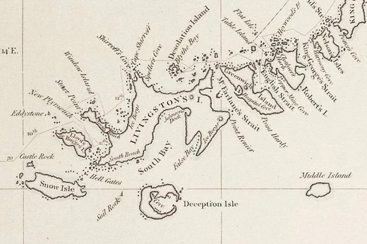
Cartography
The study and practice of making and using maps.

Cartography is the study and practice of making and using maps, combining science, aesthetics, and technique to model reality or imagined reality for effective spatial communication. Its fundamental objectives include setting a map’s agenda and selecting traits—whether physical features like roads or land masses, or abstract ones such as toponyms or political boundaries—through map editing. Terrain is represented on flat media via map projections, while irrelevant characteristics are eliminated and complexity reduced through generalization. Finally, map design orchestrates elements to best convey a message to its audience. Modern cartography provides many theoretical and practical foundations for geographic information systems and geographic information science. The history of cartography stretches back to prehistory, with debated early examples including a wall painting possibly depicting the ancient Anatolian city of Çatalhöyük from the late 7th millennium BCE, and alpine rock carvings from the 4th millennium BCE showing geometric patterns interpreted as cultivated plots. Ancient maps include the Minoan “House of the Admiral” wall painting and an engraved map of Nippur from the Kassite period. The oldest surviving world maps are from 9th century BCE Babylonia, showing Babylon surrounded by a “bitter river.” The Greeks and Romans created maps from the 6th century BCE, and Ptolemy’s 2nd century CE treatise *Geographia* contained a world map of the known Ecumene. Arab scholars translated Greek works from the 8th century, and Roman itinerarium maps portrayed the world via roads. In ancient China, geographical literature dates to the 5th century BCE, with the oldest extant maps from the 4th century BCE Qin state. A star map on an equidistant cylindrical projection appeared in a 1092 Chinese publication. Medieval European *mappae mundi* survive in about 1,100 examples. The Arab geographer al-Idrisi produced the *Tabula Rogeriana* in 1154, combining classical and contemporary knowledge, remaining the most accurate world map for three centuries. During the Age of Discovery, European cartographers used explorers’ observations and new tools like the magnetic compass, telescope, and sextant. The oldest extant globe was made in 1492, and a globular world map was produced in 1507.
- field
- Cartography
- known_for
- Making and using maps; combining science, aesthetics, and technique
- earliest_known_map
- Late 7th millennium BCE wall painting possibly depicting Çatalhöyük
- oldest_surviving_world_maps
- 9th century BCE Babylonia
- key_ancient_figure
- Ptolemy (2nd century CE, Geographia)
Lore & Background
The practice of cartography, the study and creation of maps, has ancient roots, with the earliest known examples debated. A wall painting possibly depicting the Anatolian city of Çatalhöyük dates to the late 7th millennium BCE, while 4th-millennium BCE alpine rock carvings in France and Italy show geometric patterns interpreted as cultivated plots. Other ancient maps include the Minoan "House of the Admiral" fresco, showing a seaside community, and an engraved map of the Babylonian city of Nippur from the Kassite period. The oldest surviving world maps, from 9th-century BCE Babylonia, depict Babylon on the Euphrates, surrounded by Assyria, Urartu, and a "bitter river" (Oceanus). The Greeks and Romans produced maps from the 6th century BCE onward, culminating in Ptolemy’s 2nd-century CE treatise *Geographia*, which included a world map of the known Ecumene. Roman itineraria, like the Peutinger Table, mapped the empire via its roads. In China, geographical literature dates to the 5th century BCE, with the oldest extant maps from the 4th-century BCE State of Qin. By 1092, Su Song published a star map on an equidistant cylindrical projection, the oldest printed star map. Indian cartography included charts of the pole star for navigation. Medieval European *mappae mundi* survive in about 1,100 examples. In 1154, the Arab geographer al-Idrisi created the *Tabula Rogeriana*, a world map divided into seven climatic zones, which remained the most accurate for three centuries. During the Age of Discovery, European cartographers used explorers’ observations and new tools like the compass and sextant; Martin Behaim made the oldest extant globe in 1492, and Martin Waldseemüller produced a globular world map in 1507.
Reader's Guide
Cartography, the study and practice of making and using maps, combines science, aesthetics, and technique to model reality or imagined reality for effective spatial communication. Its fundamental objectives include setting a map’s agenda and selecting traits—whether physical like roads or abstract like political boundaries—representing terrain on flat media via map projections, eliminating irrelevant characteristics through generalization, reducing complexity, and orchestrating map elements for clear communication. This discipline underpins modern geographic information systems (GIS) and geographic information science (GISc). Historically, the earliest known maps are debated; a wall painting possibly depicting Çatalhöyük dates to the late 7th millennium BCE, while 4th-millennium BCE alpine rock carvings in Mount Bego and Valcamonica show geometric patterns interpreted as cultivated plots. Other ancient examples include the Minoan “House of the Admiral” fresco and an engraved map of Nippur from the Kassite period. The oldest surviving world maps are 9th-century BCE Babylonian, showing Babylon on the Euphrates surrounded by a “bitter river.” Ancient Greeks and Romans mapped from the 6th century BCE, with Ptolemy’s 2nd-century CE Geographia containing his world map. Arab scholars translated Greek works from the 8th century, and Roman roads inspired itinerarium maps. In China, geographical literature dates to the 5th century BCE, with the oldest extant maps from the 4th-century BCE State of Qin. The 1092 Xin Yi Xiang Fa Yao by Su Song included printed star maps on an equidistant cylindrical projection. Indian cartography featured pole star charts for navigation. Medieval European mappa mundi survive in about 1,100 examples. Muhammad al-Idrisi’s 1154 Tabula Rogeriana combined classical and contemporary knowledge, remaining the most accurate world map for three centuries, divided into seven climatic zones with a circular map showing south at top. During the Age of Discovery, European cartographers used the magnetic compass, telescope, and sextant for accuracy; Martin Behaim made the oldest extant globe in 1492, and Martin Waldseemüller produced a globular world map in 1507.
Did You Know?
- The earliest known map is disputed; a wall painting possibly depicting Çatalhöyük dates to the late 7th millennium BCE.
- The oldest surviving world maps are from 9th century BCE Babylonia, showing Babylon surrounded by a 'bitter river.'
- Gerardus Mercator first used the word 'atlas' to describe a collection of maps.
Maps as Instruments of Power
From the earliest days of Western cartography, maps have served purposes far beyond simple navigation. The map historian J.B. Far from being a modern phenomenon, the deliberate alteration of geographic records has functioned as a tool of political propaganda, military counter-intelligence, and covert diplomacy for centuries. In an era when genuine peacetime was rare, fabricated maps served as weapons against every conceivable rival—political, commercial, or military. The falsification of a chart was considered a legitimate ruse de guerre, a sanctioned deception on the battlefield of information. What made this tradition particularly insidious was that it did not require an active conflict; competitive economic interests and strategic advantage were sufficient motivation to distort the very record of the world's shape and features.
The Age of Discovery and Commercial Rivalry
During the Age of Discovery, geographic knowledge carried extraordinary economic value. Ports offering fresh water and timber, deep natural harbours, and shorter sea passages were fiercely guarded secrets. Portugal exemplified this practice: after Bartolomeu Dias rounded the southern tip of Africa, the German cartographer Henricus Martellus produced a world map based on a now-lost Portuguese prototype. Scholars have argued that King John II deliberately circulated misinformation to inflate the length of the new eastern sea route to Asia, discouraging foreign competitors from exploiting Portuguese discoveries. The Dutch East India Company pursued similar tactics, persuading the government to ban publication of the Le Maire Strait passage around Cape Horn after a rival vessel used it—though the prohibition lapsed after just twelve months, allowing Willem Blaeu and others to publish corrected charts.
British Naval Secrecy from Drake to Cook
Two centuries later, the Admiralty issued nearly identical instructions to Captain James Cook, who undertook three Pacific voyages during the period of Anglo-French commercial rivalry. Cook, widely regarded as the finest navigator of his generation, has long been accused of charting errors—depicting Stewart Island as a peninsula and failing to establish Tasmania as a separate island. Off-shore islands could serve as bases for hostile operations, so Cook omitted Tasmania's insularity and Foveaux Strait from his published charts. The Admiralty went further: when Dr. Hawkesworth prepared the official account, the government's engraver altered and refined Cook's manuscript charts for print. Hawkesworth's Journals became a European bestseller, and the fabricated maps misled Britain's rivals for decades.
Censorship in the Twentieth and Twenty-First Centuries
The tradition of cartographic suppression continued well into the modern era. In former East Germany, maps of regions bordering West Germany were deliberately altered to make defection across the border more difficult. Roosevelt publicly displayed what he called a secret map of South America, allegedly produced by Hitler's government and showing Nazi designs against the United States. The document was almost certainly a fabrication by British intelligence, though Roosevelt himself may have believed it authentic. During the Cold War, the United Kingdom maintained its own regime of map censorship for sensitive installations. In the present day, the practice has migrated to the digital realm: national governments routinely submit requests to Google Earth to blur or remove imagery of sites they consider security risks, such as military bases, power plants, and communication transmitters. The medium has changed, but the underlying logic—controlling who sees what, and when—remains essentially the same as it was when Portuguese kings first stretched the coastline of Africa on a mappamundi.
More in Phantom Places & Discovery 1-24
Spotted an error? Know more?
This is a living reference — every entry is fact-audited, and reader corrections feed straight into our audit queue. Suggest an edit · See this site's audit record