
Equatorial coordinate system
A geocentric system for locating celestial objects.

Anskar · CC BY-SA 3.0
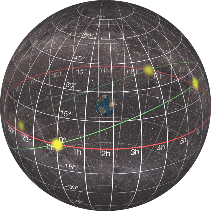
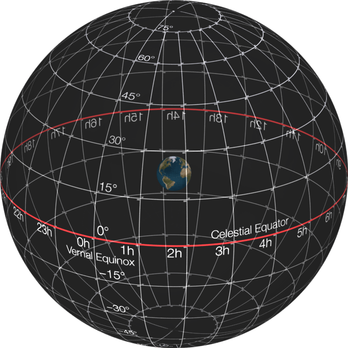
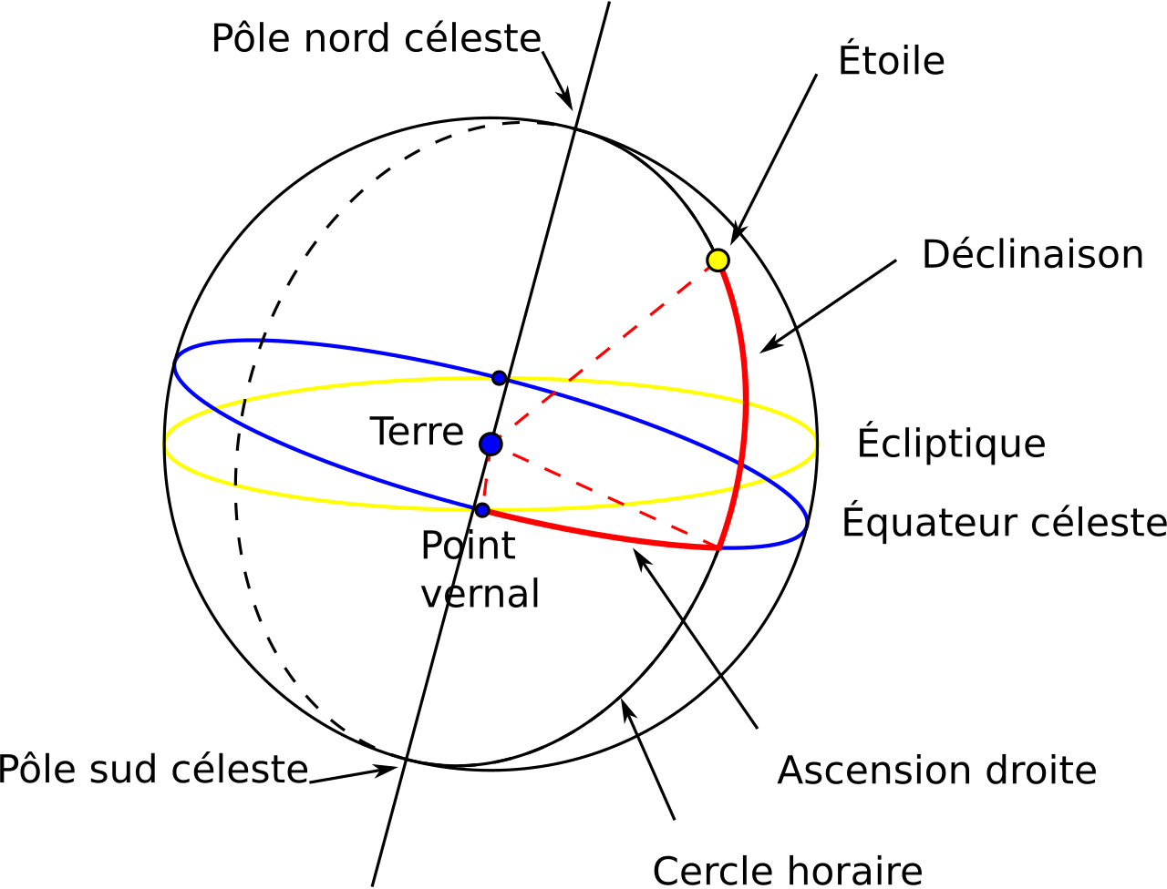
The equatorial coordinate system is a method astronomers use to locate objects in the sky. It can be expressed using either spherical or rectangular coordinates. Both versions share the same foundation: the origin is at Earth's center, making the coordinates geocentric—as if seen from a transparent Earth. The fundamental plane is the projection of Earth's equator onto the celestial sphere, called the celestial equator. The primary direction points toward the March equinox, and the system follows a right-handed convention, meaning coordinates increase northward from the fundamental plane and eastward around it. Because the system is aligned with Earth's equator and poles but does not rotate with the planet, it remains relatively fixed against the background stars.
The orientation of this reference frame is not perfectly fixed. Earth's axis undergoes a slow westward motion called precession, completing a full circle around the ecliptic poles roughly every 26,000 years. Additionally, a smaller motion of the ecliptic and a slight oscillation of Earth's axis known as nutation affect the system. To account for these movements, positions must specify the equinox of a particular date, called an epoch. The three most common epochs are: the mean equinox of a standard epoch (such as J2000.0, B1950.0, or B1900.0), which provides a fixed direction for comparing positions from different dates; the mean equinox of date, which uses the ecliptic at that date and the mean equator (adjusted for precession but not nutation), often applied in planetary orbit calculations; and the true equinox of date, which uses the ecliptic and true equator (including nutation) to give the actual intersection at a specific moment. A position is typically given as, for example, true equinox and equator of date or mean equinox and equator of J2000.0. There is no "mean ecliptic" because the ecliptic lacks small periodic oscillations.
In spherical coordinates, a star's position is usually given as a pair: right ascension and declination, without a distance. For sufficiently distant objects, this direction is the same for all observers, unlike the horizontal coordinate system, where a star's position changes with the observer's location on Earth and with Earth's rotation. Telescopes with equatorial mounts and setting circles use this system to locate objects, often with the help of a star chart or ephemeris.
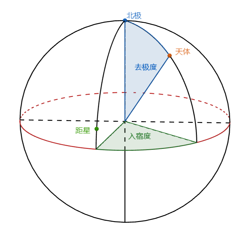
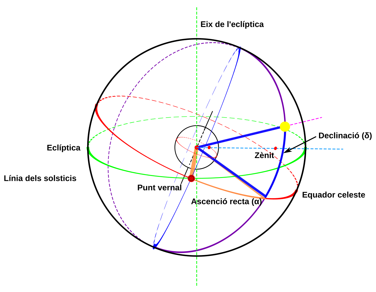
Declination (δ, abbreviated DEC) measures an object's angular distance perpendicular to the celestial equator, positive northward and negative southward. The north celestial pole, for example, has a declination of +90°. The celestial equator, the projection of Earth's equator, serves as the origin for declination, which is analogous to terrestrial latitude.
Right ascension (α, abbreviated RA) measures an object's angular distance eastward along the celestial equator from the March equinox to the object's hour circle. The March equinox is one of two points where the ecliptic crosses the celestial equator. Right ascension is typically measured in sidereal hours, minutes, and seconds rather than degrees, because it was historically determined by timing when objects crossed the meridian as Earth rotates. One hour of right ascension equals 15°, and the full celestial equator spans 24 hours. Together, right ascension and declination are often abbreviated RA/Dec.
Alternatively, hour angle (HA or LHA) is a left-handed system that measures an object's angular distance westward along the celestial equator from the observer's meridian to the object's hour circle. Unlike right ascension, hour angle increases with Earth's rotation. It essentially measures the time since the object's upper culmination, when it is on the meridian overhead. A star on the meridian has an hour angle of 0h; one sidereal hour later, it lies west of the meridian with an hour angle of 1h. Right ascension can be converted to hour angle as an intermediate step when calculating topocentric phenomena.
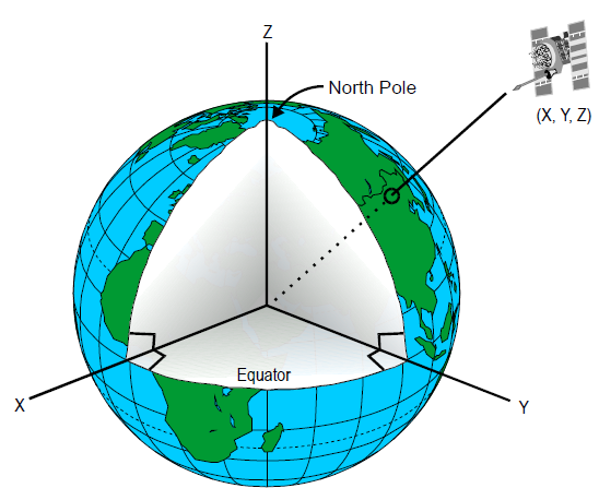
Rectangular variants of equatorial coordinates, called geocentric equatorial coordinates, all share the same origin at Earth's center, the fundamental plane in the plane of Earth's equator, the x-axis pointing toward the March equinox (where the Sun crosses the celestial equator northward in its annual path), and a right-handed convention, with the y-axis 90° east in the fundamental plane and the z-axis completing the system.
- type
- Coordinate system
- field
- Astronomy, astrodynamics
- origin
- Geocentric (centre of Earth)
- fundamental_plane
- Celestial equator
- primary_direction
- March equinox
- convention
- Right-handed
Lore & Background
The equatorial coordinate system is geocentric, meaning coordinates are as seen from the centre of Earth as if it were transparent. The fundamental plane and primary direction mean the system, while aligned with Earth's equator and pole, does not rotate with the Earth, but remains relatively fixed against the background stars. A right-handed convention means coordinates increase northward from and eastward around the fundamental plane. Superimposed on this is a smaller motion of the ecliptic, and a small oscillation of the Earth's axis, nutation. In order to fix the exact primary direction, these motions necessitate the specification of the equinox of a particular date, known as an epoch, when giving a position. The three most commonly used are mean equinox of a standard epoch (usually J2000.0, but may include B1950.0, B1900.0, etc.), mean equinox of date, and true equinox of date.
Reader's Guide
The equatorial coordinate system is fundamental to astronomy and astrodynamics. A star's spherical coordinates are often expressed as a pair, right ascension and declination, without a distance coordinate. The direction of sufficiently distant objects is the same for all observers, making it convenient to specify this direction with the same coordinates for all. In contrast, in the horizontal coordinate system, a star's position differs from observer to observer based on their positions on the Earth's surface, and is continuously changing with the Earth's rotation. Telescopes equipped with equatorial mounts and setting circles employ the equatorial coordinate system to find objects. Setting circles in conjunction with a star chart or ephemeris allow the telescope to be easily pointed at known objects on the celestial sphere. The system also has rectangular variants, all with origin at the centre of Earth, fundamental plane in the plane of Earth's equator, primary direction toward the March equinox, and a right-handed convention. These frames do not rotate with the Earth, remaining always directed toward the equinox, and drifting over time with the motions of precession and nutation. In astronomy, the position of the Sun is often specified in geocentric equatorial rectangular coordinates X, Y, Z, and the positions of planets and other Solar System bodies in ξ, η, ζ. In astrodynamics, the positions of artificial Earth satellites are specified in geocentric equatorial coordinates, also known as geocentric equatorial inertial (GEI), Earth-centred inertial (ECI), and conventional inertial system (CIS).
Did You Know?
- Declination measures angular distance perpendicular to the celestial equator, positive north, negative south.
- Right ascension is usually measured in sidereal hours, minutes, and seconds, with 15° per hour.
- Hour angle is a left-handed system measuring angular distance westward from the observer's meridian.
A Long Line of Pioneers
From Kepler's 1609 publication of his planetary laws to the present day, the mathematical description of orbital motion has been refined over four centuries. Newton's 1687 Principia offered a more general framework, including a method to determine a parabolic orbit from just three observations—a technique Edmund Halley applied to trace the paths of comets, most famously the one that now carries his name. Leonhard Euler formalized Newton's successive approximation into an analytic method in 1744, and Johann Lambert extended the work to elliptical and hyperbolic trajectories between 1761 and 1777. Carl Friedrich Gauss made a landmark contribution in 1801 when his method, using only three pairs of right ascension and declination measurements, allowed the recovery of the dwarf planet Ceres. In the twentieth century, astronomer Samuel Herrick began developing astrodynamics in the 1930s, encouraged by Robert Goddard's conviction that space navigation techniques would one day be essential. By the 1960s, the marriage of numerical methods with powerful computers made crewed lunar missions possible.
Where Orbital Mechanics Meets Celestial Mechanics
Orbital mechanics—sometimes called astrodynamics or space dynamics—brings the tools of ballistics and celestial mechanics to bear on rockets, satellites, and other spacecraft. Its motion calculations rest on Newton's laws of motion and universal gravitation. While the discipline is a core part of space-mission design and control, it sits within the broader field of celestial mechanics, which encompasses the gravitational orbit dynamics of all bodies: star systems, planets, moons, comets, and spacecraft alike. Orbital mechanics zeroes in on spacecraft trajectories—orbital maneuvers, plane changes, and interplanetary transfers—giving mission planners the tools to predict the outcomes of propulsive actions. Until the twentieth century's space era, the distinction between the two fields was minimal; at the time of Sputnik, the discipline was simply called space dynamics. The fundamental techniques, such as solving the Keplerian problem of determining position as a function of time, are shared across both domains, and their histories are almost entirely intertwined.
The Counter-Intuitive Logic of Spaceflight
One of the most striking features of orbital dynamics is how its consequences routinely defy everyday intuition. A satellite in a lower orbit moves faster relative to a planet's surface than one in a higher orbit, because gravitational pull is stronger closer in. If a spacecraft fires its engines at a single point in a circular orbit, it returns to that same point every revolution, but the rest of its path shifts—meaning a single brief thrust cannot transfer it to a different circular orbit. Thrusting opposite to the direction of travel produces an ellipse whose lowest point sits 180 degrees away, with a shorter period; thrusting in the direction of travel creates an ellipse with its highest point 180 degrees away and a longer period. Perhaps most surprisingly, a trailing spacecraft in the same circular orbit cannot simply accelerate to catch up with a leading one. Doing so raises its orbit and slows it relative to the target. A proper rendezvous demands multiple precisely timed engine burns spread across several orbital periods, often taking hours or even days. These rules grow inaccurate when atmospheric drag enters the picture or when two bodies of comparable mass interact, as in binary star systems.
From GPS to General Relativity
The practical reach of orbital mechanics extends far beyond the launch pad. Today, the same orbit-determination techniques that Gauss pioneered for Ceres are embedded in GPS receivers, used to track and catalogue newly discovered minor planets, and essential for operating every type of satellite and space probe, since knowing a spacecraft's future position to high precision is non-negotiable for mission success. While Newton's laws remain the workhorse for most calculations, general relativity provides a more exact theoretical framework. In high-gravity environments—such as orbits passing close to the Sun—or when greater precision is demanded, relativistic corrections become necessary. The field's trajectory from Kepler's empirical laws through Newton's universal gravitation, Euler's analytic formalization, Gauss's orbit recovery, Herrick's astrodynamics, and finally to computer-aided numerical methods in the 1960s illustrates a continuous thread of refinement. What began as pure mathematical astronomy has become the operational backbone of humanity's presence in space.
Gallery
Frequently Asked Questions
What is the Equatorial coordinate system?
It is a geocentric framework used in astronomy and astrodynamics to pin down where objects sit in the sky. Rather than relying on a local horizon, it anchors every measurement to Earth's equator projected outward onto the celestial sphere.
How does the Equatorial coordinate system actually locate an object?
You set the reference plane as the celestial equator, choose the March equinox as the zero-point direction, and apply a right-handed convention to assign angular or rectangular values to the target. This gives you a consistent, Earth-centred address for any star, planet, or spacecraft.
Where is the origin of the Equatorial coordinate system?
The origin sits at the centre of the Earth, making it a purely geocentric reference. Every measurement radiates outward from that single central point rather than from the observer's location on the surface.
What distinguishes the Equatorial coordinate system from other celestial grids?
Its fundamental plane is the projection of Earth's equator onto the celestial sphere, and its primary reference direction points toward the March equinox. Together with a right-handed convention, these choices set it apart from horizon-based or ecliptic-based coordinate schemes.
Why do orbit designers and astronomers rely on the Equatorial coordinate system?
It offers a stable, Earth-centred way to specify the positions of stars, planets, and artificial satellites without being tied to a particular observer's latitude or longitude. That universality makes it the go-to reference across both astronomy and astrodynamics.
More in Orbits And Celestial Mechanics 1-24
Spotted an error? Know more?
This is a living reference — every entry is fact-audited, and reader corrections feed straight into our audit queue. Suggest an edit · See this site's audit record