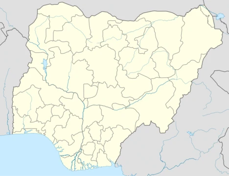
Anambra State
Southeastern Nigerian state, historic center of Igbo civilization and commerce.

via Wikipedia: Anambra State · see source
Anambra (Igbo: Alaọha Anambra) is a state in southeastern Nigeria. It shares borders with Delta State to the west, Imo and Rivers States to the south, Abia State to the southeast, Enugu State to the east, and Kogi State to the north. The capital is Awka, while Onitsha is the largest city by population. The state's name comes from the Omambala River, which flows through it; "Anambra" is an anglicized version of "Omambala." The name itself is a blend of "Anam," a local clan, and the English word "branch"—British colonialists referred to the area as the "Anam branch" when traveling north from the riverine regions. This origin is reflected in the former Anambra Local Government Area, now Anambra-West LGA, which includes Anam and neighboring clans.
Nicknamed the "Light of the Nation," Anambra is officially the fourteenth most populous state in Nigeria, though this ranking has been disputed. In 2022, Africapolis estimated Onitsha's urban population at over 8.5 million, placing it among the largest urban areas in the country. The region has hosted civilizations since at least the 9th century AD, including the ancient Kingdom of Nri, whose capital was the historic town of Igbo-Ukwu. Archaeological digs at Igbo-Ukwu and Ezira have uncovered sophisticated iron, bronze, copper, and pottery artifacts, pointing to a complex divine kingship system that lasted from around 948 AD to 1911. In towns like Ogidi, certain families held hereditary kingship rights for centuries. During the colonial era, Great Britain recognized some of these traditional rulers, appointing them as Warrant Chiefs under indirect rule to collect taxes and perform other duties.
Anambra is predominantly Igbo, and the Igbo language serves as the state's lingua franca. During the Nigerian Civil War (1967–1970), the area was part of the secessionist Republic of Biafra. The war hit Anambra hard. Biafran engineers built a relief airstrip at Uli/Amorka, code-named "Annabelle," where dangerous flights from São Tomé and elsewhere delivered food and medicine to the starving population. American pilots like Alex Nicoll were among those who flew these missions. Disgusted by the suffering and the Nigerian Air Force's harassment of relief planes, Red Cross pilot Carl Gustaf von Rosen resigned and helped Biafra form a tiny air force of five Malmö MFI-9 Minicoin planes, based at Uga airstrip. He called it the "Babies of Biafra" in memory of the children who died from starvation.
The old Anambra State was created in 1976 from part of the former East Central State, with Enugu as its capital. That territory included what is now Enugu State, Anambra State, and parts of Ebonyi State. In 1991, a reorganization split it into two states: Anambra and Enugu. The new Anambra's capital became Awka.
Geographically, Anambra is bounded by Delta and Edo States to the west (across about 97 km of the River Niger), Imo and Rivers States to the south, Abia to the southeast (for 18 km), Enugu to the east (139 km), and Kogi to the north (about 40 km). It is the eighth-most populated state in Nigeria and the second-most densely populated after Lagos. The 45 km stretch between Oba and Amorka contains a dense cluster of villages and small towns, with an estimated average density of 1,500–2,000 people per square kilometer. The climate is tropical wet and dry (savanna), with an average yearly temperature of 28.99°C—slightly lower than Nigeria's average—and about 212.36 mm of rainfall annually over roughly 243 rainy days. In 2022, the Climate Change Education and Action Programme (CLEAP) described Anambra as one of the worst places affected by climate change in Nigeria and sub-Saharan Africa.
Administratively, Anambra is one of Nigeria's most urbanized states, with over 60% of its population living in urban areas and an annual growth rate of 2.21%. Major urban centers include Onitsha, Nnewi, Ekwulobia, Ihiala, Aguleri, and the capital, Awka. Onitsha, a historic pre-colonial port city, remains a key commercial hub, while Nnewi is the state's second-largest commercial and industrial city.
- Population rank
- Fourteenth most populous state in Nigeria (disputed; Onitsha urban area estimate
Verified Timeline
Quick Facts
- Official Name
- Anambra
- Flag Alt
- Yellow and black flag with the circular Seal of Anambra centered on the yellow part.
- Nicknames
- Ife Mbà
- Motto
- Light of the Nation
- Map Alt
- Anambra is a southeastern Nigerian state, bounded by Delta, Imo, Rivers, Enugu, and Kogi states. It's situated inland, and the Anambra River, a tributary of the Niger, flows through the state.
- Subdivision Type
- Country
- Subdivision Name
- Nigeria
- Subdivision Type1
- LGAs
- Subdivision Name1
- 21
- Established Date
- 27 August 1991
- Seat Type
- Capital
- Seat
- Awka
Facts from the source article.
Lore & Background
The name Anambra is the merging of Anam and the English word 'branch'. Anam is a clan in the Omambala region and the last Igbo speaking community the British colonialists encountered while heading up to Northern Nigeria. They usually described present day Anambra as 'Anam branch' to their colleagues up North. Anambra's history stretches to the 9th century AD, as revealed by archaeological excavations at Igbo-Ukwu and Ezira. It has great works of art in iron, bronze, copper, and pottery. These have revealed a sophisticated divine Kingship administrative system, which held sway in the area of Anambra from c. 948 AD to 1911. During the Nigerian Civil War (1967–1970), Anambra State was part of the secessionist Republic of Biafra formed by Igbo nationalists. Biafran engineers constructed a relief airstrip in the town of Uli/Amorka (code named "Annabelle"). Extremely dangerous relief flights took off from Sao Tome and other sites loaded with tons of food and medicine for the distressed Biafran population. Carl Gustaf von Rosen helped Biafra to form an Airforce of five Minicoin planes Malmö MFI-9 stationed at the Uga airstrip. He named his tiny but effective air force "Babies of Biafra" in honour of the babies who died from starvation inside Biafra.
Reader's Guide
Anambra State holds significance as a core region of Igbo history and modern Nigerian urbanization. The state name was inherited from the former Anambra State, a territory that consisted of the present-day Enugu State, Anambra State and parts of Ebonyi State. The old Anambra State was formed in 1976 from the former East Central State. In 1991, a re-organisation divided Anambra into two states, Anambra and Enugu. The capital of the New Anambra is Awka. The city of Onitsha, a historic port city from the pre-colonial era, remains an important centre of commerce within the state, while Nnewi is the second largest commercial and industrial city in the state. Anambra houses the first Nigerian vehicle manufacturer, Innoson, an automobile manufacturer, located in Nnewi. Agriculture is an important economic sector in Anambra. Oil palms, maize, rice, yams and cassava are among the crops grown. There is a huge deposit of oil and gas in Nigeria, with the Anambra Basin having a great potential of 1000 trillion cubic feet of gas reserves untapped. Having more than 13 oil wells situated in Anambra, the state has the capacity to produce more than 100,000 barrels of crude oil per day, with indigenous companies like Orient Petroleum, and Sterling Oil Exploration and Production Co. LTD (SEEPCO), already leading the way. Following the attribution of eleven (11) oil wells by the Revenue Mobilization Allocation and Fiscal Commission (RMAFC) in August 2021, Anambra State joined the league of oil producing States in Nigeria.
Did You Know?
- The name Anambra is the merging of 'Anam' and the English word 'branch', as British colonialists described the area as 'Anam branch'.
- Archaeological excavations at Igbo-Ukwu and Ezira revealed a sophisticated divine kingship system that held sway from c. 948 AD to 1911.
- During the Nigerian Civil War, Biafran engineers built a relief airstrip at Uli/Amorka code-named 'Annabelle'.
- Carl Gustaf von Rosen formed an air force of five Malmö MFI-9 planes at Uga airstrip, named 'Babies of Biafra'.
- Anambra State has over 13 oil wells and the Anambra Basin has a potential of 1000 trillion cubic feet of gas reserves.
Ancient Kingdoms & Archaeological Marvels
Anambra's roots stretch back to at least the 9th century AD, a depth of history confirmed by excavations at Igbo-Ukwu and Ezira. These digs uncovered extraordinary works in iron, bronze, copper, and pottery that speak to a remarkably sophisticated society. At the heart of this world was the ancient Kingdom of Nri, whose capital sat in the historic town of Igbo-Ukwu. The kingdom operated a divine Kingship administrative system that governed the region from roughly 948 AD until 1911. In certain towns like Ogidi, local families held hereditary rights to the throne for centuries, passing authority through generations. Awka itself grew as the craft industrial centre under Nri's hegemony, while Onitsha developed as a river port and commercial city-state along the Niger. This layered past—spanning over a millennium of organized governance and artistic achievement—gives Anambra a cultural depth that few regions in West Africa can match.
The Biafran War & the Airstrip That Saved Lives
When Igbo nationalists seceded to form the Republic of Biafra in 1967, Anambra found itself at the epicentre of a devastating three-year conflict. The state bore the full weight of starvation and aerial bombardment. In the town of Uli/Amorka, Biafran engineers constructed a relief airstrip code-named "Annabelle," from which dangerously precarious flights departed from São Tomé and other distant sites, carrying tons of food and medicine to a starving population. American pilots including Alex Nicoll, along with many others, risked their lives delivering these supplies under constant harassment from the Nigerian Air Force. So moved by the death toll and the suffering of children, Swedish pilot Carl Gustaf von Rosen resigned his Red Cross role and helped Biafra field a tiny airforce of five Minicoin Malmö MFI-9 planes at the Uga airstrip. He christened this small fleet "Babies of Biafra," a name honouring the infants who perished from hunger inside the secessionist state.
The ONA Axis & Nigeria's Urban Engine
Anambra stands as one of Nigeria's most urbanized states, with over 60 percent of its residents living in urban areas and an annual population growth rate of 2.21 percent. The state ranks second in population density behind only Lagos, and the 45-kilometre corridor between Oba and Amorka packs an estimated 1,500 to 2,000 people per square kilometre into a dense cluster of villages and small towns. Onitsha, a pre-colonial port city on the Niger, has grown into a vast conurbation stretching across Idemili, Oyi, and Anambra East local government areas, home to one of the largest markets in all of West Africa. In 2022, Africapolis estimated Onitsha's urban population at over 8.5 million, making it one of the largest urban areas in the country. Nnewi serves as the state's second major commercial and industrial hub. In 2012, the tri-city cluster of Onitsha, Nnewi, and Awka was formally dubbed the ONA Industrial Axis, a designation that underscores the region's outsized role in Nigeria's economic life.
A Name Carved by River and Empire
The name Anambra carries a layered history of indigenous identity and colonial encounter. It is the anglicized form of Omambala, the river that threads through the state and feeds into the Niger. According to local accounts, British colonialists heading north from the riverine areas encountered the Anam clan in the Omambala region—the last Igbo-speaking community they met before entering Northern Nigeria. They referred to the area as "Anam branch" to colleagues further north, a phrase that eventually hardened into the state's name. When the territory was formally created as a state in 1976 from the former East Central State, Anambra LGA (now Anambra-West, with Olumbanasa) carried the name. Before that, the British had already embedded themselves in local power structures, appointing noble leaders as Warrant Chiefs under their system of indirect rule in the Protectorate of South Nigeria, authorizing these chiefs to collect taxes and administer local affairs from the 19th century onward.
Gallery


Frequently Asked Questions
What is Anambra State?
Anambra is a southeastern Nigerian state bordered by Delta, Imo, Enugu, and Kogi. It is one of the country's most densely urbanized regions and has long served as a hub of Igbo culture and trade.
What is Anambra State's nickname?
Anambra is popularly known as the 'Light of the Nation,' a title that reflects its historic role as a center of commerce and cultural influence in southeastern Nigeria.
What is the capital of Anambra State?
The official capital is Awka, although Onitsha is by far the state's most populous urban center, with an estimated population in the range of one to two million people.
What ancient kingdom is linked to Anambra State?
The territory that is now Anambra was home to the Kingdom of Nri, a powerful Igbo polity whose origins trace back to at least the 9th century AD. This makes it one of the oldest documented centers of organized civilization in the region.
Why is Anambra State significant in Nigeria?
Anambra ranks fourteenth in population among Nigerian states and is widely regarded as a historic heartland of Igbo civilization and long-distance trade. Its deep urbanization and commercial heritage give it outsized cultural and economic influence relative to its size.
More in Nigerian States 1-24
Related in Nigerian States
Links follow this subject's own source article.
Spotted an error? Know more?
This is a living reference — every entry is fact-audited, and reader corrections feed straight into our audit queue. Suggest an edit · See this site's audit record