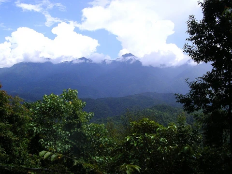
Altai Nature Reserve
A UNESCO biosphere reserve in the Altai Mountains of Siberia.

The Altai Nature Reserve (also known as Altayskiy Zapovednik) is a strictly protected sanctuary in the Altai Mountains of southern Siberia, Russia. It forms part of the UNESCO World Heritage Site "Golden Mountains of Altai," celebrated for its exceptional biodiversity and minimal human impact, and is also recognized as a UNESCO Biosphere Reserve. The reserve covers the eastern shore of Lake Teletskoye for 30 kilometers (19 miles) and extends 230 kilometers (140 miles) southeast into the high mountains. It lies within the Ulagansky and Turochaksky districts of the Altai Republic.
The reserve is long and narrow, running from northeast to southwest along the Teletskoye basin and into the rugged interior. Elevations reach up to 3,500 meters (11,500 feet), and the territory averages 35 kilometers (22 miles) in width across its 230-kilometer (140-mile) length. Lake Teletskoye sits at the northwestern end, while the Chulyshman River flows into the lake, with the Chulyshman valley forming part of the western boundary. Most of the reserve consists of the plains and alpine ridges of the Chulyshman Highlands. Over 20 percent of the area is rock, scree, and gravel, and the high plateaus contain more than 1,000 alpine lakes larger than 1 hectare (2.5 acres) each.
The reserve lies within the Sayan montane conifer forests ecoregion, characterized by mountains cut by river valleys, high rainfall, and rich biodiversity. Vegetation varies with elevation and terrain, with forests divided into three main subzones: light needle-leaf sparse taiga, dark needle-leaf taiga, and dark taiga. The Altai Reserve remains largely undisturbed by human activity and is one of the few pristine areas of this ecoregion. It covers 9.4 percent of the Altai Republic and has no roads. The climate is humid continental with cool summers (Köppen subarctic, Dfc), featuring mild summers (only 1–3 months above 10°C or 50°F) and cold, snowy winters (coldest month below -3°C or 26.6°F). Over the last 50 years, July has been the warmest month (16.8°C or 62.2°F), January the coldest (-8.3°C or 17.1°F), and average rainfall 865 millimeters (34.1 inches).
Common trees include coniferous species such as Siberian larch, Siberian cedar, and Siberian fir. Near Lake Teletskoye, secondary forests of birch and alder occur, but most of the southern reserve is untouched—cedars there have been measured up to 1.8 meters (5 feet 11 inches) in diameter and 400–450 years old. Scientists have recorded over 1,500 species of vascular plants, including 22 listed as vulnerable in the Russian Federation's Red Book. The reserve hosts more than 70 mammal species, including two endangered ones: the snow leopard and the Altai argali. There are 19 fish species, mostly in Lake Teletskoye, such as pike, perch, and whitefish; grayling is most common in streams. Of 331 bird species, most (48 percent) are passerines (159 species), followed by waders (48 species), Falconiformes (30 species), and geese (29 species); the remaining 66 species account for only 20 percent.
As a strict nature reserve, the Altai Reserve is largely closed to the public, though scientists and those with environmental education purposes can arrange visits with park management. Six ecotourist routes are open to the public, but permits must be obtained in advance, with management recommending 2–3 months lead time. The main office is in Gorno-Altaysk. The routes include: Chichelgansky Zigzag (overlooking Lake Teletskoye, with an ethno-cultural center and Yaylyu waterway hike); Belinskaya Terrace (featuring ancient Turkic monuments like the "Kaeser-Tash" stone warrior and "IT-Bash" stone dog); Corbou Waterfall (a 25-kilometer boat ride and hike to a 13-meter waterfall); Cordon Chelyush - Waterfall (softwood forest and Altai views); Kokshe Waterfall (a ranger-led hike to the waterfall on the Koskhe River, the largest right-bank tributary of Lake Teletskoye); and Great Falls of the Chulchinsky (a hike for experienced mountain hikers only).
- elevation_range
- Up to 3,500 metres (11,500 ft)
Lore & Background
The Altai Reserve has an elongated shape running from the northeast to southwest along the Teletskoye basin and into the high interior. Elevations rise to 3,500 metres (11,500 ft). This territory averages 35 km (22 miles) wide through its 230 km (140-mile) length. Lake Teletskoye is in the upper northwest end. The Chulyshman River runs into the lake, with the Chulyshman valley forming part of the western border of the Altai Reserve. Most of the reserve is the plains and alpine ridges of the Chulyshman Highlands. Over 20% of the territory is rock, scree and gravel. On the high plateaus there are over 1,000 alpine lakes greater than 1 hectare (2.5 acres) in size. The Altai reserve has been for the most part undisturbed by human activity, and is one of the few remaining pristine areas of this ecoregion. It covers 9.4% of the entire Republic of Altai, and there are no roads in the reserve.
Reader's Guide
The Altai Nature Reserve is significant as a core component of the UNESCO World Heritage Site 'Golden Mountains of Altai' and as a UNESCO Biosphere Reserve. It protects a highly biodiverse and isolated mountain ecosystem, including over 1,500 species of vascular plants, 70 mammal species, 331 bird species, and 19 fish species. Among its notable endangered species are the Snow Leopard and the Altai argali. The reserve's forests contain ancient Siberian cedars up to 1.8 metres in diameter and 400–450 years old. As a strict nature reserve, public access is limited, but six ecotourist routes are available with permits obtained 2–3 months in advance. The reserve covers 9.4% of the entire Altai Republic and has no roads, preserving its pristine character.
Did You Know?
- The Altai Reserve includes the 30 km (19-mile) east bank of Lake Teletskoye and stretches 230 km (140 miles) into the high mountains.
- Over 20% of the reserve's territory is rock, scree and gravel.
- There are over 1,000 alpine lakes greater than 1 hectare (2.5 acres) in size on the high plateaus.
- The reserve covers 9.4% of the entire Republic of Altai, and there are no roads in the reserve.
- Over the past 50 years, the warmest month in the reserve has been July (16.8 °C; 62.2 °F) and the coldest month January (−8.3 °C; 17.1 °F).
Geography & Topography
The Altai Nature Reserve sprawls in a long, narrow corridor that stretches roughly 230 km (140 miles) from the northeast toward the southwest, threading along the Teletskoye basin before plunging deep into the high interior mountains. Its average width is around 35 km (22 miles), and at its upper northwest tip it cradles the shoreline of Lake Teletskoye, where the Chulyshman River pours its waters into the lake. That same river valley traces the reserve's western border. Elevation climbs dramatically across the territory, reaching as high as 3,500 metres (11,500 ft) above sea level. The landscape is dominated by the plains and alpine ridges of the Chulyshman Highlands, and more than 20% of the ground surface is bare rock, scree, or gravel rather than soil. Perched on the high plateaus, over 1,000 alpine lakes each exceed 1 hectare (2.5 acres) in area. Administratively, the reserve spans Ulagansky and Turochaksky Districts in the northern and eastern reaches of the Altai Republic.
Biodiversity & Living World
The reserve's forests are anchored by three coniferous giants: Siberian larch, Siberian cedar, and Siberian fir. Along the slopes hugging Lake Teletskoye, secondary stands of birch and alder appear, but the deeper southern reaches remain largely untouched. Some of the cedars on site have been measured at nearly 1.8 metres (5 ft 11 in) in diameter and are estimated to be 400 to 450 years old. Scientists working within the reserve have catalogued more than 1,500 species of vascular plants, among them 22 species flagged as vulnerable in the Red Book of the Russian Federation. The mammal community exceeds 70 species and includes two endangered species: the Snow Leopard and the Altai argali. Aquatic life is concentrated largely in Lake Teletskoye, where 19 fish species thrive, including pike, perch, and whitefish, while grayling dominates the flowing streams. The avian roster stands at 331 species, with nearly half being passerines (159 species), followed by waders (48 species), Falconiformes (30 species), and geese (29 species).
Climate & Ecoregion
Altai sits within the Sayan montane conifer forests ecoregion, a landscape defined by mountains dissected by river valleys, high levels of precipitation, and high biodiversity. Vegetation shifts with altitude into three distinct forest subzones: light needle-leaf sparse taiga, dark needle-leaf taiga, and dark taiga. Because the reserve has remained largely free of human disturbance, it stands as one of the few remaining pristine areas of this ecoregion. It encompasses 9.4% of the entire Republic of Altai, and notably, not a single road cuts through its territory. The climate is a Humid continental climate, with a cool summer (Köppen climate classification Subarctic climate, Dfc). This climate is characterized by mild summers (only 1–3 months above 10 °C; 50 °F) and cold, snowy winters (coldest month below −3 °C; 26.6 °F). Over the past 50 years in the Altai reserve, the warmest month has been July (16.8 °C; 62.2 °F), the coldest month January (−8.3 °C; 17.1 °F), and the average rainfall has been 865 millimetres (34.1 in).
Access, Permits & Ecotourism
As a strict nature reserve, the Altai Reserve is mostly closed to the general public, although scientists and those with 'environmental education' purposes can make arrangements with park management for visits. There are six 'ecotourist' routes in the reserve, however, that are open to the public, but require permits to be obtained in advance. Park management recommends allowing 2–3 months in advance for obtaining permits. The main office is in the city of Gorno-Altaysk. The six ecotourist routes open to the public (permits required) are: Chichelgansky Zigzag (overlook of Lake Teletskoye, ethno-cultural visitor center, Yaylyu waterway hike); Belinskaya Terrace (ancient monuments of the Turkic period - 'Kaeser-Tash' stone warrior, 'IT-Bash' stone-dog); Corbou Waterfall (25 km boat ride and hike, 13 meter waterfall); Cordon Chelyush - Waterfall (softwood forest, overviews of Altai); Kokshe Waterfall (orientation by reserve ranger, hike to Kokshe Waterfall on the Koskhe River, largest right bank tributary of Lake Teletskoye); and Great Falls of the Chulchinsky (hike for experienced mountain hikers only).
Frequently Asked Questions
What is Altai Nature Reserve?
It is a strict nature sanctuary (zapovednik) in the Altai Mountains of southern Siberia, Russia, where human activity is heavily restricted to protect the local ecosystem. It is one of the older and most isolated protected zones in the region.
What UNESCO designations does Altai Nature Reserve hold?
The reserve is included in the 'Golden Mountains of Altai' World Heritage Site and is simultaneously part of the UNESCO World Network of Biosphere Reserves. These dual listings recognize both its outstanding natural values and its role as a living, evolving landscape.
How high does the terrain at Altai Nature Reserve go?
Elevations in the reserve climb to roughly 3,250 metres (about 10,663 feet) above sea level, placing it among the highest-altitude protected areas in the Altai range.
Why is Altai Nature Reserve considered ecologically significant?
Its deep remoteness in the Altai Mountains has kept it largely untouched by development, allowing a rich mosaic of plant and animal communities to persist. That isolation is a key reason it is recognized as a high-biodiversity zone.
Where exactly is Altai Nature Reserve located in Russia?
It sits in the Altai Mountains of far southeastern Siberia, in the mountainous border region of the Russian Federation. The area is characterized by high peaks, alpine meadows, and valleys that are difficult to access.
More in Mountain And Alpine Reserves 1-19
Spotted an error? Know more?
This is a living reference — every entry is fact-audited, and reader corrections feed straight into our audit queue. Suggest an edit · See this site's audit record