State of Mexico
Most populous state, surrounding Mexico City on three sides.

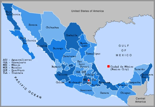
The State of Mexico, officially just “Mexico,” is one of Mexico’s 32 federal entities. It shares its name with both the country and the capital, Mexico City, so it’s often called Edomex for short. It’s the most populous state in the country and the second most densely populated. Located in central Mexico, it wraps around Mexico City on three sides. Its neighbors are Querétaro and Hidalgo to the north, Morelos and Guerrero to the south, Michoacán to the west, and Tlaxcala and Puebla to the east. The state has 125 municipalities. Its capital is Toluca de Lerdo (commonly called Toluca), and its biggest city is Ecatepec de Morelos (Ecatepec).
The area that is now the State of Mexico was the heart of the pre-Hispanic Aztec Empire. During Spanish colonial rule, it became part of New Spain. After independence in the 19th century, Mexico City was chosen as the new nation’s capital, and its territory was split off from the state. Later, parts of the state were carved out to create the states of Hidalgo, Guerrero, and Morelos. These splits gave the state its current shape: the Toluca Valley west of Mexico City and a panhandle that curves around the north and east of the capital. People and things from the state are called *mexiquense*, not *mexicano* (which refers to the whole country).
The name “Mexico” comes from the Nahuatl word *Mēxihco*, originally the name for the Valley of Mexico, where the Mexica (the Aztec Triple Alliance) lived. After the Spanish conquest, “Mexico” came to refer to Tenochtitlan (Mexico City) and all the lands it once controlled, including several other states that were originally part of the State of Mexico. Two possible origins exist for the name: one from *metztli* (moon) and *xictla* (navel), meaning “from the navel of the moon,” based on the Aztec idea that moon craters form a rabbit with a navel; the other from *Mextictli*, an alternate name for the god Huitzilopochtli. *Anáhuac* was the term for all Aztec-dominated territories, from *Cem Anáhuac* (“the entire earth” or “surrounded by waters,” referring to Lake Texcoco). It was proposed as an early name for the whole nation before independence, to distinguish it from the colonial administrative division that became the State of Mexico.
The earliest signs of human life in the state are a quartz scraper and obsidian blade found at Tlapacoya, an island in the former Lake Chalco, dating to the Pleistocene era about 20,000 years ago. The first people were hunter-gatherers. Stone-age tools, mammoth bones, and human remains have turned up across the state, especially at Los Reyes Acozac, Tizayuca, Tepexpan, San Francisco Mazapa, El Risco, and Tequixquiac. Between 20,000 and 5000 BCE, people shifted to settled villages with farming and domesticated animals. Corn was the main crop, and stone grinding tools became common. Later crops included beans, chili peppers, and squash. Ceramics appear around 2500 BCE, with early examples from Tlapacoya, Atoto, Malinalco, Acatzingo, and Tlatilco.
The Tepexpan Man is a key find for anthropologists, helping to understand the Valley of Mexico 5,000 years ago and establish a regional occupation timeline. Some scholars say it’s 11,000 years old, others 8,000, and some 5,000. Originally thought to be male, recent research suggests it’s female, though this is still debated. A sacrum bone from Tequixquiac is considered prehistoric art. Those people were nomadic, hunting large animals like mammoths and gathering fruit. The Tequixquiac Bone, carved from a camelid bone around 22,000 BCE, is one of the most notable primitive art finds in the Americas; its purpose is unknown, but it reflects the artist’s worldview. The first permanent settlers of Tequixquiac were Aztecs and Otomi, drawn by abundant rivers and springs, and they farmed and raised animals.
The earliest major civilization in the state was Teotihuacan, whose Pyramids of the Sun and Moon were built between 100 BCE and 100 CE. Between 800 and 900 CE, the Matlatzincas established their rule with Teotenango as their capital—a walled city with plazas, terraces, temples, altars, living quarters, and a ball court. In the 15th century, the Aztecs conquered the Toluca and Chalco valleys to the west and east of the Valley of Mexico. Part of the Toluca Valley was also held by the Purépechas. Other pre-Hispanic powers included the Chichimecas in Tenayuca and the Acolhuas in Huexotla.
- Capital
- Toluca de Lerdo ("Toluca")
- Largest City
- Ecatepec de Morelos ("Ecatepec")
- Population Rank
- Most populous in Mexico
- Density Rank
- Second most densely populated in Mexico
- Demonym
- mexiquense
- Official Name
- Mexico (colloquially Edomex)
Lore & Background
Later, the Matlatzincas established Teotenango as their capital, and in the 15th century the Aztecs conquered the Toluca and Chalco valleys.
Reader's Guide
The State of Mexico is significant as the most populous entity in Mexico and as the historical core of the Aztec Empire. Its name derives from the Nahuatl Mēxihco, possibly meaning "from the navel of the moon" or from an alternate name for the god Huitzilopochtli. After the Spanish Conquest, the region was reorganized as the audiencia of Mexico and later as part of New Spain. Over time, parts were separated to form the states of Hidalgo, Guerrero, and Morelos, leaving the state with its current shape: the Toluca Valley to the west of Mexico City and a panhandle extending around the north and east. The demonym mexiquense distinguishes people and things from the state from mexicano, which refers to the country as a whole.
Did You Know?
- The state is colloquially called Edomex, from E[sta]do Méx[ico].
- The name "Mexico" may derive from metztli (moon) and xictla (navel), meaning "from the navel of the moon."
- The state surrounds Mexico City on three sides.
Identity, Naming, and the 'Edomex' Distinction
The State of Mexico carries one of the most confusing naming situations in the country. It shares its official name with the nation itself and with the federal capital, Mexico City, a collision that has driven residents and outsiders alike to adopt the colloquial shorthand Edomex, a contraction of Estado de México. The people of the state are called mexiquense, a deliberate linguistic separation from mexicano, which refers to the entire country. The name traces back to the Nahuatl word Mēxihco, originally denoting the Valley of Mexico where the Mexica, the proper name for the Aztec Triple Alliance, built their cities. Two etymologies are proposed: one linking the term to metztli (moon) and xictla (navel), referencing the Aztec belief that lunar craters form a rabbit bearing a navel; the other connecting it to Mextictli, an alternate name for the god Huitzilopochtli. Before independence, the broader Aztec-dominated territories were called Anáhuac, meaning 'surrounded by waters,' a reference to Lake Texcoco at the center of the Aztec world, and the term was even proposed as an early name for the whole nation to distinguish it from the preexisting administrative division of New Spain.
Geography, Population, and Administrative Layout
Toluca de Lerdo serves as the capital, though Ecatepec de Morelos is the largest city by population. The state's most defining geographic feature is its embrace of Mexico City on three sides, creating a distinctive silhouette: the Toluca Valley sits to the west of the capital, while a long panhandle wraps around the north and east. To the north it borders Querétaro and Hidalgo; to the south, Morelos and Guerrero; to the west, Michoacán; and to the east, Tlaxcala and Puebla. This configuration is not accidental but the residue of centuries of territorial reorganization. The state's central location and dense population make it a critical corridor connecting the capital to the broader Mexican interior, and its municipalities collectively house a share of the national population that rivals that of many entire countries.
Deep Time: Prehistoric and Pre-Hispanic Inhabitants
These early peoples were hunter-gatherers who pursued mammoths and gathered wild fruits, as indicated by stone tools, mammoth bones, and human remains found across sites like Los Reyes Acozac, Tizayuca, and Tequixquiac.
Territorial Shaping: From Aztec Core to Modern Borders
The State of Mexico's current borders are the product of layered political transformations spanning over five centuries. Its territory once formed the heartland of the pre-Hispanic Aztec Empire, encompassing the lands controlled by Tenochtitlan and its allied cities. Following the Spanish Conquest, these territories were reorganized into the audiencia of Mexico, which included Mexico City and portions of what are now several other states. When Mexico achieved independence in the nineteenth century, the capital city was carved out as a separate entity. Over subsequent decades, additional portions were detached to create the states of Hidalgo, Guerrero, and Morelos. Each of these separations progressively reduced the state's area, leaving behind the configuration seen today: the Toluca Valley anchoring the western portion and a narrow panhandle encircling the north and east of Mexico City. The Spanish colonial practice of applying the name México to Tenochtitlan and all the pre-conquest lands it controlled, including territories now belonging to those three successor states, further illustrates how the modern state is a residue of a once much larger Aztec domain.
Frequently Asked Questions
What is the State of Mexico?
It is one of Mexico's 32 federal entities, situated in the central region and wrapping around Mexico City on three sides. It holds the distinction of being the country's most populous state, with Toluca de Lerdo as its capital.
How does the State of Mexico's story end?
Its historical arc runs from being the core territory of the Aztec Empire, through its incorporation into New Spain, to its present identity as a modern federal state. In that current form, it continues as one of Mexico's 32 constituent entities governed from Toluca.
Why is the State of Mexico important?
It was the heartland of the pre-Hispanic Aztec Empire and later a cornerstone of colonial New Spain, giving it deep historical significance. Today its sheer population size and its three-sided encirclement of Mexico City make it indispensable to the nation's urban and economic landscape.
What is the largest city in the State of Mexico?
Ecatepec de Morelos holds the title of the state's largest city, while Toluca de Lerdo serves as the official capital. Residents of the state go by the demonym mexiquense.
More in Mexican States 1-19
Spotted an error? Know more?
This is a living reference — every entry is fact-audited, and reader corrections feed straight into our audit queue. Suggest an edit · See this site's audit record