Puebla
State in east-central Mexico, known for industry and cultural festivals.

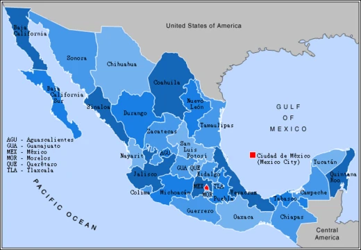
Puebla is one of Mexico’s 31 states, which together with Mexico City form the country’s federal entities. Its official name is the Free and Sovereign State of Puebla. The state is split into 217 municipalities, with Puebla City serving as its capital. Located in east-central Mexico, it shares borders with Veracruz to the north and east; Hidalgo, México, Tlaxcala, and Morelos to the west; and Guerrero and Oaxaca to the south. The state’s origins trace back to the founding of Puebla City by the Spanish in 1531, placed in a valley to protect the trade route linking Mexico City and the port of Veracruz. By the late 1700s, the region had become a colonial province under its own governor. After the Mexican War of Independence in the early 1800s, it became the State of Puebla. Since then, the area—especially around the capital—has grown economically, mainly through industry, even though it has been the site of several battles, most famously the Battle of Puebla. Today, Puebla ranks among Mexico’s most industrialized states, but most of this development is limited to Puebla City and other urban centers, leaving many rural areas behind.
The state is known for the china poblana, mole poblano, active literary and arts scenes, and festivals like Cinco de Mayo, the Ritual of Quetzalcoatl, Day of the Dead celebrations (especially in Huaquechula), and Carnival (especially in Huejotzingo). Five major indigenous groups live here: Nahuas, Totonacs, Mixtecs, Popolocas, and Otomi, mostly in the far north and far south.
Geography: Puebla sits in Mexico’s central highlands, between the Sierra Nevada and the Sierra Madre Oriental. It is triangular, narrowing toward the north. It borders Veracruz, Oaxaca, Guerrero, Morelos, the State of Mexico, Tlaxcala, and Hidalgo. The state covers 33,919 square kilometers, ranking 20th in size among the 31 states, and contains 4,930 named communities.
Mountains: Most of Puebla’s mountains belong to the Sierra Madre Oriental and the Trans-Mexican Volcanic Belt. The former is locally called the Sierra Norte del Puebla, entering from the northwest and splitting into smaller chains such as the Sierra de Zacapoaxtla, Sierra de Huauchinango, Sierra de Teziutlán, Sierra de Tetela de Ocampo, Sierra de Chignahuapan, and Sierra de Zacatlán—though local names may vary. Notable elevations include Apulco, Chichat, Chignahuapan, Soltepec, and Tlatlaquitepec. The highest peaks are volcanoes on the state’s borders: Pico de Orizaba (Citlaltépetl, 5,747 meters), Popocatépetl (5,452 meters), Iztaccíhuatl (5,286 meters), and Malinche (4,461 meters), bordering Veracruz, Mexico State, and Tlaxcala respectively. In the south, major elevations include the Sierra de Atenahuacán, Zapotitlán, Lomerío al Suroeste, and the Sierra de Tehuacán. A small chain called the Sierra Madre del Golfo separates much of the state from Veracruz. The state’s natural geography divides into several subregions: the Huasteco Plateau, Llanuras y Lomeríos zone, Lagos y Volcanes del Anáhuac, Chiconquiaco, Llanuras y Sierras de Querétaro e Hidalgo, Cordillera Costera del Sur, Mixteca Alta, Sierras y Valles Guerrerenses, Sierras Centrales de Oaxaca, Sierras Orientales, and Sur de Puebla. The Huasteco Plateau and Llanuras y Lomeríos zone lie in the north and northeast, while Lagos y Volcanes del Anáhuac sits in the center and north; together they cover over half the state. The east and northeast hold the Chiconquiaco and Llanuras y Sierras de Querétaro e Hidalgo areas, accounting for about three percent. The Cordillera del Sur and Mixteca Alta are in the west and southwest, covering less than 2.5 percent. Sur de Puebla, in the southwest, makes up 26 percent. Other southern subregions—Sierras y Valles Guerrerenses, Sierras Centrales de Oaxaca, and Sierras Orientales—together account for about 15 percent.
Hydrology: Three major river systems shape Puebla’s hydrology. One is based on the Balsas River (also called the Atoyac), which starts from melting runoff of the Halos, Telapón, and Papagayo mountains, plus waters from the Iztaccíhuatl volcano and the Zahuapan River from Tlaxcala. Tributaries like the Acateno, Atila, Amacuzac, Molinos, and Cohetzala feed it. The river has one major dam, Valsequillo (Manuel Ávila Camacho), and eventually flows west to the Pacific. The second system drains into the Gulf of Mexico, including the Pantepec, Cazones, Necaxa, Laxaxalpan, San Pedro/Zun, Zempoala, Apulco, Cedro Viejo, Salteros, Martínez de la Torre, and other rivers on the state’s east side. This system has two major dams: Necaxa and Mazatepec. The third is the closed Oriental Basin, containing many small lakes, freshwater springs, and some volcanically heated springs. Well-known ones include Chignahuapan, Agua Azul, Amalucan, Cisnaquillas, Garcicrespo, Almoloya, and Rancho Colorado. Lakes include Chapulco, San Bernardino, Lagunas Epatlán, Ayutla, Almoloyan, Alchichica, Pahuatlán, Las Minas, Aljojuca, and Tecuitlapa.
Climate: Puebla’s wide range of altitudes produces many different climates. The average temperature is 16°C (61°F), but this varies greatly by location. A rainy season runs from May to October, with overall precipitation of 801 mm (31.54 inches). The state has eleven climate zones, but five dominate. The center and south have a temperate, semi-moist climate, averaging 15°C (59°F) and 858 mm (33.78 inches) of rain. The southwest has a warm to hot, semi-moist climate, with 830 mm (32.68 inches) of precipitation and an average temperature of 22°C (72°F). The north...
- Capital
- Puebla City
- Rank by size
- 20th of 31 states
- Average temperature
- 16 °C (61 °F)
Quick Facts
- Official Name
- 0.2em · Free and Sovereign State of Puebla / Estado Libre y Soberano de Puebla (Spanish) / Tlahtohcayotl Puebla (Nahuatl)
- Settlement Type
- State
- Shield Size
- 75px
- Motto
- Unidos En El Tiempo, En El Esfuerzo, En La Justicia y En La Esperanza / (United in time, effort, justice and hope)
- Anthem
- Himno al Estado de Puebla
- Subdivision Type
- Country
- Subdivision Name
- Mexico
- Subdivision Type1
- Capital / and largest city
- Subdivision Name1
- Puebla de Zaragoza
- Subdivision Type2
- Largest metro
- Subdivision Name2
- Greater Puebla
- Subdivision Type3
- Municipalities
Facts from the source article.
Lore & Background
Puebla is located in the central highlands of Mexico between the Sierra Nevada and the Sierra Madre Oriental, with a triangular shape narrowing to the north. The state's hydrology is formed by three major river systems: one based on the Balsas River (also known as the Atoyac), one emptying into the Gulf of Mexico, and the closed Oriental Basin with many small lakes and springs. Puebla has eleven different climate zones, with five predominating, ranging from temperate and semi-moist in the center and south to warm and very wet in the north, and cold on high volcano peaks.
Reader's Guide
Puebla's significance lies in its role as a historically strategic trade route and its modern industrial development. Since the Mexican War of Independence, the area has continued to grow economically, mostly through industry, despite being the scene of a number of battles, the most notable being the Battle of Puebla. The state is home to five major indigenous groups: Nahuas, Totonacs, Mixtecs, Popolocas, and Otomi, mostly in the far north and far south. It is known for cultural contributions such as china poblana, mole poblano, active literary and arts scenes, and festivals including Cinco de Mayo, Ritual of Quetzalcoatl, Day of the Dead celebrations (especially in Huaquechula), and Carnival (especially in Huejotzingo).
Did You Know?
- Puebla is bordered by seven states: Veracruz, Oaxaca, Guerrero, Morelos, State of Mexico, Tlaxcala, and Hidalgo.
- Puebla has eleven different climate zones, with average temperatures ranging from cold on volcano peaks to warm in the north and southwest.
The Road to War – A Tripartite Crisis Turns French
The roots of the Battle of Puebla trace back to a financial dispute. What began as a multilateral debt-collection effort quickly fractured. Initial agreements at Orizaba in late January recognized Juárez's government and Mexican sovereignty, and all three powers agreed to hold negotiations inland. France made clear its intention to invade and interfere in Mexican governance, violating prior treaties. Britain and Spain settled their claims and withdrew, but Napoleon III's France chose a different path: leveraging the moment to build an empire anchored in Mexico. A well-armed French warship had already forced Juárez's administration into exile, and now a sizable French army was landing, setting the stage for a conflict that would culminate on the hills above Puebla.
Lorencez's Gambit – Storming the Forts
His objective was clear: seize the forts of Loreto and Guadalupe, perched on the hills overlooking the city, which would guarantee control of Puebla itself. He had been advised by Mexican collaborators Juan Almonte and Antonio de Haro y Tamariz to either attack the orchard of the Convento del Carmen opposite the fortified heights or simply bypass Puebla and march on the capital. He did neither. Instead, at half past eleven on May 5, Lorencez assembled an attack column of two battalions of zouaves, a battery under Captain Bernard, and four pieces of marine artillery from Captain Mallat's unit, with marine infantry and riflemen held in reserve. The assault on the two forts failed repeatedly. Unable to dislodge the Mexican defenders, Lorencez was forced to retreat to Orizaba to await reinforcements, and he was subsequently dismissed from command.
A Ragged Defense – Juárez's Faithful Soldiers
President Juárez, operating from a base in the north after being driven from the capital, assembled what could only be described as a ragged force of loyal soldiers and dispatched them south to Puebla. By May 4, General Miguel Negrete's division had taken up positions in the Guadalupe and Loreto Forts, while the remainder of the Republican Army quartered within the city itself. The contrast between the two forces was stark: the French brought well-equipped battalions of zouaves, marine artillery, and cavalry, while the Mexican defenders were a patchwork of faithful troops holding elevated ground. Mexican historian Francisco Bulnes later observed that Lorencez lacked the troops to starve the city, the artillery to intimidate it into surrender, and the resources for a gradual siege. His only viable option was a risky frontal storming of the forts—an assault that, as the battle would prove, could scarcely be expected to succeed against a determined and well-positioned defense.
From Battlefield to Cultural Memory
The Mexican victory at Puebla against a better-equipped French force became a powerful source of patriotic inspiration across the nation. In the state of Puebla itself, the anniversary is observed as El Día de la Batalla de Puebla, a day of local pride and remembrance. Recognition of the holiday extends to some degree in other parts of Mexico, though it remains most deeply rooted in the state where the fighting took place. Across the Atlantic, the date took on an entirely different cultural life. In the United States, May 5 evolved into Cinco de Mayo, a broad celebration of Mexican heritage that has grown far beyond the original military context. The French, meanwhile, did not abandon their campaign. Under the new command of Élie Frédéric Forey, French forces eventually captured Puebla, and the broader intervention continued. Yet the initial repulse on that May morning had already accomplished something no subsequent French victory could erase: it demonstrated that a smaller, less-equipped Mexican army could stand and win against a European power, and that memory continues to shape cultural identity to this day.
More in Mexican States 1-19
Spotted an error? Know more?
This is a living reference — every entry is fact-audited, and reader corrections feed straight into our audit queue. Suggest an edit · See this site's audit record