Chihuahua (state)
Largest Mexican state, known for Copper Canyon and Paquimé.

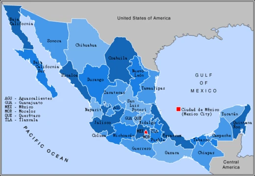
Chihuahua, officially the Free and Sovereign State of Chihuahua, is one of Mexico’s 31 states, which together with Mexico City make up the country’s 32 federal entities. It sits in the northwestern part of Mexico, bordering Sonora to the west, Sinaloa to the southwest, Durango to the south, and Coahuila to the east. To the north and northeast, it shares a long border with the U.S. states of New Mexico and Texas. The state takes its name from its capital, Chihuahua City, though its largest city is Ciudad Juárez. During the Reform War and French intervention, Benito Juárez declared Chihuahua City the capital of Mexico in 1864, a status it held until 1867. In 1640, the city of Parral was the world’s leading silver producer. Miguel Hidalgo was executed in Chihuahua City on July 30, 1811, during the Mexican War of Independence.
Though best known for the Chihuahuan Desert, the state actually has more forested land than any other Mexican state except Durango. Its varied climate supports a wide range of plants and animals. The terrain is mostly rugged mountains and broad river valleys. The Sierra Madre Occidental, part of the same continental mountain spine as the Rocky Mountains, dominates the landscape and contains the state’s top attraction: Las Barrancas del Cobre, or Copper Canyon, a canyon system larger and deeper than the Grand Canyon. Chihuahua also holds the Naica cave, the largest crystal cave in Mexico, discovered in 2001. Another notable site is Paquimé, in Casas Grandes, an archaeological site built by the Mogollon culture of Northern Mexico and recognized as a UNESCO World Heritage site. By area, Chihuahua is Mexico’s largest state, covering 247,455 square kilometers (95,543 square miles)—slightly larger than the United Kingdom and slightly smaller than Wyoming, the tenth-largest U.S. state. This size earns it the nickname *El Estado Grande* (“The Great State” or “The Big State”).
The famous Mexican train Ch-P, known as “Chepe,” starts from Calle Méndez in Chihuahua City, winds through Copper Canyon in the Sierra Madre Occidental, and ends in Los Mochis on the Gulf of California coast. On the slopes of the Sierra Madre Occidental—around Casas Grandes, Cuauhtémoc, and Parral—lie vast prairies of short yellow grass that produce most of the state’s agricultural output. Most residents live along the Rio Grande Valley and the Conchos River Valley. The name “Chihuahua” has long been debated by historians and linguists; the most accepted theory traces it to the Nahuatl language, meaning “the place where the water of the rivers meet” (a confluence, similar to Koblenz).
The state has a diversified economy and is Mexico’s top exporter, driven by manufacturing in electronics and transportation equipment. Its three main economic centers are Ciudad Juárez, an international manufacturing hub; Chihuahua City, the capital; and Cuauhtémoc, the state’s primary agricultural center and a globally recognized apple producer. The capital, Chihuahua City, ranks among Mexico’s most competitive cities according to IMCO, and its municipality has a Human Development Index of 0.842, one of the highest in the country after Monterrey and Mexico City. Today, Chihuahua serves as a key commercial route, benefiting from billions of dollars in international trade under NAFTA, though it also suffers from illicit trade and drug-cartel activity, especially along the border. The state is home to inventors such as Victor Leaton Ochoa, Rafael Mendoza Blanco, and Luis T. Hernandez Terrazas.
**History**
**Prehistory**
The earliest human evidence in Chihuahua comes from the Samalayuca Dune Fields and Rancho Colorado. Clovis points found in northeastern Chihuahua have been dated to between 12,000 and 7000 BCE, and these early inhabitants are thought to have been hunter-gatherers. Later, people in the state developed farming, domesticating maize. At the archaeological site of Cerro Juanaqueña in northern Chihuahua, evidence of squash cultivation, irrigation techniques, and ceramic artifacts dates to around 2000 BCE.
Between 300 and 1300 CE, in the southern part of the state—a region known as Aridoamerica—groups survived by hunting, gathering, and farming. Nahuan speakers called these groups the Chichimeca; they are the ancestors of the Tepehuán, who speak a language in the Piman subfamily of Uto-Aztecan languages. Meanwhile, between 300 and 1300 CE in the northern part of the state, along the wide, fertile San Miguel Valley, the Casas Grandes “Big Houses” culture developed into an advanced civilization. This civilization is part of the major prehistoric Mogollon culture, related to the Ancestral Puebloans. Paquimé was its center, and extensive archaeological evidence shows commerce, agriculture, and hunting there and at Cuarenta Casas (“Forty Houses”). Cueva de las Ventanas (“Cave of Windows”), a series of cliff dwellings along an important trade route, and Las Jarillas Cave, which scrambles along the canyons of the Sierra Madre Occidental in northwestern Chihuahua, date between 1205 and 1260 and belong to the Paquimé culture. Cuarenta Casas is believed to have been a branch settlement from Paquimé, established to protect the trade route from attack. Archaeologists think the civilization began to decline during the 13th century, and by the 15th century, some Paquimeros sought refuge in the Sierra Madre Occidental while others migrated north and joined the Ancestral Puebloans.
- Capital
- Chihuahua City
- Largest City
- Ciudad Juárez
- Nickname
- El Estado Grande
- Highest Point
- Sierra Madre Occidental
- Major Economic Centers
- Ciudad Juárez, Chihuahua, Cuauhtémoc
Lore & Background
Later, around 2000 BCE, inhabitants developed farming, as shown by squash cultivation and irrigation at Cerro Juanaqueña. This civilization declined by the 15th century, with some people migrating to the Sierra Madre Occidental or joining the Ancestral Puebloans.
Reader's Guide
Chihuahua's significance lies in its vast size, diverse geography, and historical role as a crossroads of indigenous and colonial cultures. Its archaeological site Paquimé reflects the advanced Mogollon culture. Economically, Chihuahua is Mexico's top exporting state, driven by manufacturing in electronics and transportation equipment, particularly in Ciudad Juárez, a major international manufacturing center. The state's agricultural hub, Cuauhtémoc, is known for apple production. Chihuahua City, the capital, ranks among Mexico's most competitive cities. The state's legacy includes its role in the Mexican War of Independence and as a temporary national capital. However, it also faces challenges from drug cartel activity, especially along the border. The famous Chepe train connects Chihuahua City to Los Mochis, passing through the Copper Canyon, highlighting the state's natural and cultural attractions.
Did You Know?
- Chihuahua is the largest state in Mexico by area, slightly larger than the United Kingdom and slightly smaller than Wyoming.
- The state's name likely derives from Nahuatl, meaning 'the place where the water of the rivers meet.'
Frequently Asked Questions
What is Chihuahua (state)?
Chihuahua is one of Mexico's 31 states, situated in the northwestern part of the country and bordered by Sonora, Sinaloa, Durango, Coahuila, plus the U.S. states of New Mexico and Texas. Its nickname 'El Estado Grande' reflects its status as the largest state by area in all of Mexico.
What is the difference between Chihuahua's capital and its largest city?
Chihuahua City serves as the state capital, while Ciudad Juárez is actually the most populous urban center. The state takes its name from the capital rather than the larger city, and Cuauhtémoc is another key economic hub.
What natural landmarks is Chihuahua famous for?
The state is renowned for Copper Canyon, a dramatic canyon system in its mountainous interior, and the ancient Paquimé archaeological site. Together these features make Chihuahua a major destination for nature and history enthusiasts exploring northwestern Mexico.
More in Mexican States 1-19
Spotted an error? Know more?
This is a living reference — every entry is fact-audited, and reader corrections feed straight into our audit queue. Suggest an edit · See this site's audit record