San Luis Potosí (city)
Capital and industrial hub of San Luis Potosí, Mexico.

San Luis Potosí—often shortened to San Luis or SLP, and known in Otomi as Nmiñ'u—serves as both the capital and the largest city of the Mexican state that shares its name. It also functions as the seat of government for the surrounding municipality of San Luis Potosí. Situated at an elevation of 1,864 meters (6,115 feet), the city proper has an estimated population of 824,229, while its metropolitan area—which includes the neighboring city of Soledad de Graciano Sánchez and other nearby municipalities—reaches about 1,221,526 residents, making it the eleventh-largest metro area in Mexico.
Located in the west-central part of the state at 22.16°N, 100.98°W, the municipality covers 1,443.14 square kilometers (557.20 square miles) and belongs to the Bajío macroregion. The city takes its name from Louis IX of France (San Luis Rey de Francia), its patron saint. The addition of "Potosí" references the famously rich silver mines of Potosí, Bolivia, discovered roughly forty years before the city's founding. The discovery of silver and gold deposits in nearby Cerro de San Pedro drove the establishment of San Luis Potosí in 1592.
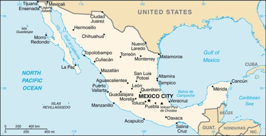
Today, the city ranks as one of central Mexico's key industrial centers, with a strong manufacturing base. Over recent decades, many foreign companies have invested here, drawn by its strategic position: it lies halfway between Mexico City and the U.S. border, and at the center of a triangle formed by Mexico's three largest cities—Mexico City, Guadalajara, and Monterrey. Beyond industry, state and federal programs have recently promoted San Luis Potosí as a tourist destination. Its historic center showcases a striking blend of artistic styles in numerous buildings, standing as a major example of colonial architecture. In 2010, UNESCO listed this historic center as a World Heritage Site within the Camino Real de Tierra Adentro.
**History**
**Pre-colonial period** Before the Spanish arrived, the area now forming the state of San Luis Potosí fell into two cultural zones: Mesoamerica and Aridoamerica. The southern and eastern parts were home to Otomi and Huastec kingdoms, while the northern and central-west regions—where the city sits—were inhabited by Chichimeca peoples. "Chichimeca" is a broad term for various nomadic groups that lived on the northern edges of the Aztec Empire, in what is now northern Mexico. Because they were nomadic, they built no large cities or permanent settlements like Mesoamerican civilizations. Historians describe them as highly warlike, often fighting among themselves, though their languages differed and their customs were similar.
After Spanish conquistadors and their Indigenous allies arrived, it took roughly a century to colonize the northern Aridoamerican territories. When settlers founded the first settlements in the region in the late 1500s, they faced constant attacks from Guachichil tribes. These fiercely resistant groups targeted traders traveling along new routes to Zacatecas. Conquistadors and missionaries called the site of present-day San Luis "El Gran Tunal" (Grand Place of Tuna fruit). In 1589, peace between the Chichimeca and Spanish settlers was achieved through the efforts of Miguel Caldera and Brother Diego de la Magdalena, ending the Chichimeca War.
**Colonial period** A Franciscan mission was established in the area in 1583, nine years before the city's founding. In early 1592, mines were discovered at Cerro de San Pedro. However, the lack of water there made settlement and proper mineral extraction impossible. A nearby valley had abundant water, leading to the creation of a new township to support mining operations. The legal founding of San Luis Potosí occurred on November 3, 1592, as part of the Viceroyalty of New Spain, under a charter commission raised by Viceroy Luís de Velasco and granted to Miguel Caldera (considered the city's historic founder) and Juan de Oñate. In 1786, San Luis Potosí became the capital of the Intendancy of San Luis Potosí, one of twelve new administrative units created under the Bourbon reforms.
**Independence** During the French invasion of Mexico in 1863, San Luis Potosí briefly served as the capital of the republican government under President Benito Juárez. The Plan of San Luis Potosí, issued on November 20, 1910, marked the beginning of Mexico's revolution against dictator Porfirio Díaz. After Díaz had his opponent Francisco I. Madero arrested and imprisoned during the 1910 presidential election, Madero fled and issued the plan, declaring the election void and calling on Mexicans to take up arms.
Today, the downtown area features plazas and colonial architecture. The Plaza de Armas holds a cathedral and the governor's palace (1770). The nearby Templo de Nuestra Señora del Carmen, founded in 1749 by Fray Nicolás de Jesús María, is known for its colorful tiled domes and famous altars, and is considered among Mexico's finest churches. San Luis also has the bullring Plaza de Toros Fermin Rivera. Outside the historic center, a modern industrial city has grown. The Universidad Autónoma de San Luis Potosí (UASLP) is located here, based on a Jesuit College founded in 1624; the Instituto Científico y Literario was later raised to university status.
- country
- Mexico
- state
- San Luis Potosí
- climate
- Cold semi-arid (BSk)
Lore & Background
In pre-Hispanic times, the area now occupied by the city was inhabited by Chichimeca peoples, nomadic groups who did not build permanent settlements. After the arrival of Spanish conquistadores, the region was called 'El Gran Tunal' by missionaries and settlers.
Reader's Guide
San Luis Potosí played a notable role in Mexican history. Madero, is considered the opening shot of the Mexican Revolution against dictator Porfirio Díaz. The city's historic center displays a mixture of artistic styles and is a major example of colonial architecture; in 2010 it was listed as a UNESCO World Heritage Site within Camino Real de Tierra Adentro. Today, the city is a major commercial and industrial center, attracting foreign investment due to its strategic location. The city has also been promoted as a tourist destination and was ranked the third-best place to live in Mexico by the magazine The Investor.
Did You Know?
- The city is named after Louis IX of France, with 'Potosí' added in reference to the rich mines of Potosí, Bolivia.
- The historic center was listed as a UNESCO World Heritage Site in 2010 within Camino Real de Tierra Adentro.
Origins, Naming, and the Chichimeca Context
The city's very name tells a story of ambition and aspiration. The "San Luis" portion honors Louis IX of France, the city's patron saint, while "Potosí" was tacked on in homage to the legendary silver and gold mines of Potosí, Bolivia—mines discovered roughly four decades before this new settlement took shape. However, the arid conditions at the mine site made settlement and extraction impractical, so the township was established in a nearby valley where water flowed freely. The broader context was tense: the region had been inhabited by nomadic Chichimeca peoples, and Spanish settlers faced relentless Guachichil attacks on trade routes to Zacatecas.
A City That Shaped Mexican Politics
San Luis Potosí has repeatedly found itself at the crossroads of Mexican political upheaval. Madero—having fled after Porfirio Díaz had him arrested following a stolen presidential election—issued the Plan of San Luis Potosí. That document declared the election void and called on Mexicans to rise in arms, effectively serving as the opening shot of the Mexican Revolution. The city's role as a political flashpoint underscores how a mid-sized provincial center could become the stage for decisions that reshaped the entire nation.
Colonial Splendor and Living Heritage
The historic center of San Luis Potosí is a dense tapestry of colonial-era architecture that has earned international recognition. In 2010, it was inscribed as a UNESCO World Heritage Site as part of the Camino Real de Tierra Adentro, a designation that acknowledges its role as a major exemplar of colonial building in Mexico. The buildings collectively display a remarkable blend of artistic styles, reflecting centuries of layered influence. Beyond the ecclesiastical and civic landmarks, the city also houses the Plaza de Toros Fermín Rivera, a bullring that speaks to the region's cultural traditions. This architectural heritage coexists with a modern industrial city that has been growing on the periphery, creating a striking contrast between the colonial core and contemporary expansion.
Strategic Location and Modern Economic Identity
Today, San Luis Potosí occupies a uniquely advantageous geographic position that has drawn sustained industrial investment. The city sits roughly halfway between Mexico City and the United States border, and it falls squarely within the triangle formed by Mexico's three largest urban centers: Mexico City, Guadalajara, and Monterrey. This strategic placement, combined with its location in the Bajío macroregion, has made it a magnet for foreign manufacturers in recent decades, establishing it as one of central Mexico's principal industrial hubs with a prolific manufacturing sector. The metropolitan area, which incorporates the neighboring city of Soledad de Graciano Sánchez and surrounding municipalities, counts approximately 1.2 million residents, making it the eleventh largest in the country. Beyond industry, state and federal programs have promoted the city as a tourist destination, leveraging its colonial heritage.
Frequently Asked Questions
Who is San Luis Potosí (city)?
San Luis Potosí, often shortened to San Luis or SLP, is the capital and most populous city of the Mexican state that shares its name. It also serves as the municipal seat for the surrounding municipality of San Luis Potosí.
What are San Luis Potosí (city)'s powers and role?
The city functions as the state's primary industrial and commercial engine, anchoring manufacturing and trade activity across the region. Its geographic position places it squarely inside the economic triangle connecting Mexico City, Guadalajara, and Monterrey.
Where does San Luis Potosí (city) sit on the map?
It occupies a central-northern spot in Mexico, roughly halfway between Mexico City and the U.S. border. That midpoint location makes it a natural logistics and distribution node for goods moving north-south.
What is San Luis Potosí (city)'s climate like?
The city falls under a cold semi-arid classification (BSk), meaning it experiences dry conditions with cool to cold winters and warm, relatively short summers. Annual rainfall is modest, giving the landscape a notably arid character.
Why is San Luis Potosí (city) important to the broader story of Mexican cities?
As both the political capital and the industrial heart of its state, it represents a key mid-size urban center that bridges Mexico's northern industrial corridor with the central economic belt. Its role as a commercial hub keeps it firmly in the national conversation about manufacturing, trade, and regional development.
More in Mexican Cities 1-20
Spotted an error? Know more?
This is a living reference — every entry is fact-audited, and reader corrections feed straight into our audit queue. Suggest an edit · See this site's audit record