Culiacán

Culiacán, whose full official name is Culiacán Rosales, serves as both the capital and the largest city of the Mexican state of Sinaloa, located in the northwestern part of the country. It lies within the municipality that shares its name. The settlement was established on September 29, 1531, by the Spanish conquistadors Lázaro de Cebreros and Nuño Beltrán de Guzmán, who initially called it "Villa de San Miguel" after its patron saint, Michael the Archangel.
As of the 2020 census conducted by INEGI, the city proper had an estimated 808,416 residents, ranking it as the 21st most populous city in Mexico. Its broader metropolitan area, home to 1,003,530 people, was the 17th largest such area in the country.
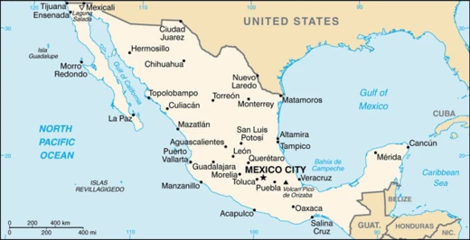
Geographically, Culiacán occupies a valley on the lower slopes of the Sierra Madre Occidental, at the point where the Tamazula and Humaya Rivers meet to create the Culiacán River, at an elevation of 55 meters above sea level.
The city's name comes from the Nahuatl language. The word *colhua* means "ancestor" or refers to a specific tribe, while the suffix *–cán* indicates a place. This combination yields "place of the Colhua." Some historians have suggested alternative meanings, such as "snake place" or "crooked hill," but the most widely accepted interpretation is "place of the colhuas," or "inhabited by the colhua tribe." Another frequent reading is "place of worshiping the god Coltzin."
In the prehispanic era, an ancient indigenous settlement called Huey Colhuacan existed, dating back to the year 628 CE according to the Tecpatl calendar. The Aztecs built this settlement during their pilgrimage, though its exact location is unknown; it is generally thought to have been near the present-day town of Culiacáncito.
When the Spanish arrived in the 16th century, they found that local farmhouses were organized into indigenous nations by the Tahues tribe, which grouped people of shared origin, language, and tradition. Other indigenous groups in the original territory included the Tebacas, Pacaxes, Sabaibo, and Achires. After conquering the area in 1531, de Cebreros and de Guzmán divided the acquired lands into three provinces. One of these, Culiacán, was bordered to the south by the Elota River and to the north by the Mocorito River, and it fell under the jurisdiction of the Kingdom of Nueva Galicia. This arrangement lasted until 1786, when a new administrative system was implemented, merging Sonora and Sinaloa into the province of Arizpe while the older province of Culiacán remained unchanged.
During the era of independent Mexico, independence was proclaimed in Culiacán on October 6, 1821. The settlement was granted city status on July 21, 1823, when a congressional decree separated the provinces of Sonora and Sinaloa. In 1824, under the Constitutive Act of the Mexican Federation, Sinaloa and Sonora were reunited to form the Estado de Occidente. On October 13, 1830, the two provinces were permanently separated by decree, and Culiacán was designated the capital of the state of Sinaloa. In 1861, during the conservative government of the French Intervention, prefectures were established, and a Municipalities Law divided the districts into City Councils. The Badiraguato District was dissolved and became a municipality within the Culiacán District. From 1859 to 1873, the state capital was moved from Culiacán to Mazatlán. During the Restored Republic, Governor Eustaquio Buelna confronted the port's merchants and returned the capital to Culiacán, with the Local Congress confirming its status.
In 1878, Culiacán had three City Halls, headquartered in Culiacán, Quilá, and Badiraguato. This arrangement lasted until 1880, when Badiraguato reverted to being a district with its previous boundaries. Municipalities were established by law in 1912 as a new form of internal government, but the law did not take effect until 1915, when political directors were abolished and the districts were freed. Culiacán was officially established as a municipality by decree on April 8, 1915. Its original limits included the area that later became the Municipality of Navolato, which was separated from Culiacán on August 27, 1982, removing 2,285 square kilometers (882 square miles) of valley farmland from the city's jurisdiction.
Later, the State Congress approved an extension of the capital's name, giving it its current official name, Culiacán de Rosales. "Rosales" honors Antonio Rosales, a prominent Mexican military figure who fought in the second French Intervention and the Reform War and also served as governor of Sinaloa.
During World War II, the United States faced a shortage of medical morphine after opium supplies from Asia were cut off by the Pacific War. In response, Mexican authorities, working with U.S. officials, expanded regulated opium poppy cultivation in northwestern Mexico, including rural areas around Culiacán in Sinaloa. Farmers in the mountainous regions of the Sierra Madre Occidental near the city produced opium that was processed into legal morphine for Allied wartime medical use. Although the program ended after 1945, the agricultural knowledge, smuggling routes, and local intermediary networks developed during the war persisted. Historians and criminologists view these postwar networks as an early foundation for later illicit drug trafficking organizations in Sinaloa.
Starting in the late 1950s, Culiacán became a major hub for drug trafficking to the United States. The completion of the Pan-American Highway and the regional airport in the 1960s accelerated the development of distribution infrastructure for the few enterprising families that would later dominate international drug cartels along Mexico's Pacific Northwest. The Sinaloa Cartel made Culiacán its primary base.
- Founders
- Lázaro de Cebreros and Nuño Beltrán de Guzmán
- Country
- Mexico
- State
- Sinaloa
- Known for
- Capital of Sinaloa, major hub for drug trafficking, site of the Battle of Culiacán
Lore & Background
Upon the Spanish arrival in the 16th century, they found indigenous nations including the Tahues, Tebacas, Pacaxes, Sabaibo, and Achires. Its official name 'Culiacán de Rosales' honors Antonio Rosales, a Mexican military figure who fought in the second French Intervention and Reform War.
Reader's Guide
Culiacán's significance stems from its role as the political and economic heart of Sinaloa, but its legacy is deeply tied to drug trafficking. During World War II, the U.S. and Mexican authorities expanded regulated opium poppy cultivation near Culiacán to produce morphine for Allied forces. After the war, the agricultural knowledge, smuggling routes, and networks developed during that period persisted, forming an early foundation for later illicit drug organizations. From the late 1950s onward, Culiacán emerged as a major hub for drug trafficking to the United States, accelerated by the completion of the Pan-American Highway and the regional airport in the 1960s. The Sinaloa Cartel made Culiacán its primary base.
Did You Know?
- The city's name derives from the Nahuatl word 'Colhuacán', meaning 'place of the colhuas'.
- During World War II, opium poppies were legally cultivated near Culiacán to produce morphine for Allied forces.
Indigenous Roots and Spanish Founding
Long before European arrival, the valley carried deep cultural memory. The city's name echoes that prehispanic past: in Nahuatl, "colhua" denotes an ancestral people or tribal name, and the locative suffix "-cán" marks a place, yielding the widely accepted reading "place of the Colhua." Alternative interpretations include "snake place," "crooked hill," or a site devoted to the deity Coltzin. The Tahues tribe had organized local farmhouses into nations of shared origin, language, and tradition, while the Tebacas, Pacaxes, Sabaibo, and Achires also inhabited the territory. The conquistadors named their settlement "Villa de San Miguel" in honor of the Archangel Michael and divided the conquered lands into three provinces. The Culiacán province stretched between the Elota and Mocorito rivers, administered under the Kingdom of Nueva Galicia.
From Province to State Capital
Culiacán's political identity was shaped by decades of administrative reshuffling. That capital title was not permanent. Governor Eustaquio Buelna, after clashing with the port's merchants, secured the capital's return, and Local Congress reaffirmed Culiacán's status. Municipal government came later. The State Congress later extended the official name to Culiacán de Rosales, honoring Antonio Rosales, who fought in the Reform War and the second French Intervention and later governed Sinaloa.
Wartime Cultivation and a Bitter Inheritance
During World War II, the United States faced a critical shortage of medical morphine after the Pacific War severed opium shipments from Asia. Mexican authorities, working in coordination with U.S. officials, responded by expanding regulated opium poppy cultivation across northwestern Mexico, including the rural highlands surrounding Culiacán. Farmers in the Sierra Madre Occidental, just beyond the city, grew poppies whose opium was processed into legal morphine for Allied medical use. The agricultural know-how, the smuggling routes threaded through mountain passes, and the local intermediary networks built to move product to market all persisted long after the wartime mandate lapsed. Historians and criminologists have identified these postwar structures as an early foundation for the illicit drug trafficking organizations that would later dominate Sinaloa. The infrastructure of a state-sanctioned wartime operation quietly became the skeleton of a far darker enterprise.
Geography, Growth, and the Battle of 2019
Culiacán occupies a broad valley on the slopes of the Sierra Madre Occidental, where the Tamazula and Humaya Rivers converge to form the Culiacán River at an elevation of just 55 metres above sea level. This geographic position has long made it a natural crossroads. From the late 1950s onward, Culiacán's strategic location and growing infrastructure drew it into the orbit of international drug trafficking. The completion of the Pan-American Highway and the regional airport during the 1960s accelerated the expansion of distribution networks, and the Sinaloa Cartel ultimately made the city its primary base. After an ultimately unsuccessful attempt to arrest Ovidio Guzmán, a relative of Joaquín "El Chapo" Guzmán, widespread gunfights erupted across the city, killing multiple people. In what has since been called the "Battle of Culiacán," police were eventually forced to release the detainee, leaving the city shaken and the event seared into national memory.
Frequently Asked Questions
What is Culiacán?
It is the capital and most populous city of the Mexican state of Sinaloa, situated in the country's northwestern region. Its official full name is Culiacán Rosales.
Where is Culiacán located geographically?
The city occupies a valley along the foothills of the Sierra Madre Occidental, positioned right at the point where the Tamazula and Humaya Rivers merge to form the Culiacán River.
What does the name "Culiacán" actually mean?
It is built from the Nahuatl word "colhua" (referring to an ancestor or a tribal name) plus the locative suffix "-cán" meaning "place of." The most common translations are "place of the colhuas" or "place of worshiping the god Coltzin."
Who founded Culiacán?
The city was established by Lázaro de Cebreros and Nuño Beltrán de Guzmán during the Spanish colonial period.
Why is Culiacán well known beyond just being a state capital?
The city has gained significant international attention as a major hub for drug trafficking and as the site of the Battle of Culiacán, events that have made it a frequently referenced location in global news.
More in Mexican Cities 1-20
Spotted an error? Know more?
This is a living reference — every entry is fact-audited, and reader corrections feed straight into our audit queue. Suggest an edit · See this site's audit record