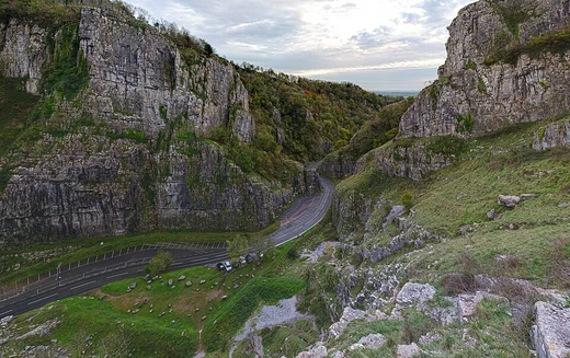
Verdon Gorge
A deep limestone canyon in southeastern France.

The Verdon Gorge, also called the Gorges du Verdon or Gòrja de Verdon, cuts through the limestone of southeastern France’s Provence-Alpes-Côte d’Azur region. Stretching roughly 25 kilometers (15.5 miles) and reaching depths of up to 700 meters (0.4 miles), it was carved by the Verdon River, whose name comes from its distinctive turquoise-green hue. The river runs between the towns of Castellane and Moustiers-Sainte-Marie, slicing 700 meters deep into the limestone mass before emptying into the artificial Lake of Sainte-Croix at the canyon’s end.
Tourists flock to the gorge, driving along its rim, renting kayaks to paddle the river, or hiking its trails. The towering limestone walls, hundreds of meters high, draw rock climbers; the area is a top destination for multi-pitch climbing, with about 1,500 routes ranging from 20 meters (65 feet) to over 400 meters (1,300 feet).
The gorge’s geological story began in the Triassic period, when the Provence region sank beneath the sea, depositing thick limestone layers. During the Jurassic, a warm, shallow sea allowed corals to thrive. In the Cretaceous, what is now Basse Provence rose, and the sea reached the future Alps, which later emerged in the Tertiary era. This tectonic activity fractured the Jurassic limestone, creating valleys and relief. The Verdon Gorge’s origins trace to this time. In the Quaternary, large-scale glaciation turned water bodies into ice rivers, reshaping the landscape through scouring and striation. After the ice receded, river erosion continued, forming the present gorge. The Verdon’s riverbed was scoured a second time, clearing accumulated coral and limestone sediments, with water flow reaching 2,000 to 3,000 cubic meters per second.
The gorge first appeared in print between 1782 and 1804. By the late 1800s, it was included in French tourist guides. According to Graham Robb’s *The Discovery of France*, it remained unknown outside France until 1906.
In a notable recent event, on 10 July 2006, France’s Council of State annulled a public-use declaration for a high-voltage power line proposed by EDF that would have crossed the gorge. This ended a 23-year fight by environmental groups to protect the site, which hosts protected animal and plant species. During the 2022 European drought, the river’s water levels dropped drastically, and some sections dried up entirely.
The Verdon River originates near the col d’Allos hill in the Trois Eveches mountain range, flowing 175 kilometers to join the Durance River near Vinon-sur-Verdon. Between Castellane and the Galetas bridge, it passes through Lake of Sainte-Croix, created by a dam of the same name. Before the dam, the village of Les Salles-sur-Verdon sat on the river plain; it was demolished in 1973 to form the reservoir and rebuilt higher up, making it France’s youngest village. For part of its length, the gorge marks the border between the Var département to the south and Alpes-de-Haute-Provence to the north, both in Provence-Alpes-Côte d’Azur. The region between Castellane and Lac de Sainte-Croix is divided into three parts: the Prégorges from Castellane to Pont de Soleils, the deepest section from Pont de Soleils to l’Imbut, and the Canyon from l’Imbut to Pont du Galetas. The gorge is narrow and deep, ranging from 250 to 700 meters in depth and 6 to 100 meters wide at river level, while its summits span 200 to 1,500 meters from rim to rim. It has been compared to the Grand Canyon in the United States.
Five hydroelectric dams were built on the Verdon between 1929 and 1975, from Castellane to Gréoux-les-Bains. Their reservoirs include Lac de Castillon (which flooded the village of Castillon), Lac de Sainte-Croix (which flooded Les Salles-sur-Verdon), Lac d’Esparron-Gréoux (locally called lac d’Esparron), the Chaudanne reservoir, and the Quinson reservoir (sometimes misnamed lac de Montpezat after the nearby village).
Notable features include the Styx du Verdon, a sub-canyon linked to the Greek mythological river Styx, and the Imbut (also spelled Embut or Embucq), where the Verdon disappears underground beneath massive rock formations before re-emerging.
Tourism peaks in summer, drawn by the river’s turquoise color, which comes from glacial sources and suspended rock flour minerals. The gorge is accessible from the north via route D952 on the right bank (Castellane to Moustiers-Sainte-Marie) and from the south via routes D71, D90, and D955 on the left bank (Aiguines to Castellane). Beyond climbing, the area attracts fishermen, especially fly fishers, and offers hiking, canoeing, paragliding, rafting, and canyoning.
- location
- Provence-Alpes-Côte d'Azur, southeastern France
- length
- about 25 km (15.5 mi)
- formed_by
- Verdon River
- notable_feature
- turquoise-green water
- climbing_routes
- over 1,500
Lore & Background
The Verdon Gorge is a river canyon in southeastern France, about 25 kilometers long and up to 700 meters deep. Its defining characteristic is the turquoise-green color of the Verdon River, which carved the ravine through limestone between the towns of Castellane and Moustiers-Sainte-Marie. The gorge’s appearance features narrow, deep sections ranging from 6 to 100 meters wide at the river level, while the distance between the summits on either side spans 200 to 1500 meters. The limestone walls rise several hundred meters high, attracting rock climbers with over 1,500 routes from 20 to over 400 meters in length. The gorge is split into three parts: the pre-gorge from Castellane to Pont de Soleils, the deepest section from Pont de Soleils to l’Imbut, and the canyon from l’Imbut to the Pont du Galetas. At its end, the river flows into the artificial Lake of Sainte-Croix. The gorge’s formation began during the Triassic period when the region was submerged, leaving limestone deposits, followed by Jurassic coral growth in a warm shallow sea. Later glaciation and erosion shaped the modern canyon. Notable features include the Styx du Verdon, a sub-canyon, and the Imbut, where the river disappears underground beneath rock structures. The gorge is popular for driving, kayaking, and hiking, and its turquoise color comes from glacial sources and suspended rock flour.
Reader's Guide
The Verdon Gorge is a river canyon in southeastern France, formed by the Verdon River cutting through limestone over millions of years. Its geological history began during the Triassic period when the area was submerged under the sea, depositing thick limestone layers. In the Jurassic, a warm shallow sea allowed coral growth, and later tectonic activity fractured the limestone. During the Quaternary period, glaciation reshaped the landscape, and subsequent river erosion, with water flows reaching up to 3000 cubic metres per second, scoured the gorge to its current depth of up to 700 metres and length of about 25 kilometres. The river’s distinctive turquoise-green colour comes from glacial sources and suspended rock flour. The gorge is divided into three sections: the Prégorges, the deepest part, and the Canyon, ending at the artificial Lake of Sainte-Croix. Notable features include the Styx du Verdon, a sub-canyon, and the Imbut, where the river disappears underground. The site supports protected animal and plant species, and its limestone walls, hundreds of metres high, offer 1,500 climbing routes from 20 to over 400 metres. The gorge is a popular destination for driving, kayaking, hiking, and climbing, and it forms the border between the Var and Alpes-de-Haute-Provence départements.
Did You Know?
- The Verdon River is named for its turquoise-green color.
More in Caves & Gorges 1-23
Related in Caves & Gorges
Links follow this subject's own source article.
Spotted an error? Know more?
This is a living reference — every entry is fact-audited, and reader corrections feed straight into our audit queue. Suggest an edit · See this site's audit record