
Aphrodisias
Ancient city of Aphrodite, once metropolis of Caria, now a UNESCO World Heritage site.
Last updated
Where it is
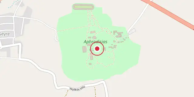
Coordinates: 37°42′29″N 28°43′26″E (37.7080, 28.7240) · Open in OpenStreetMap
Coordinates and connected clubs: the infobox of Wikipedia: Aphrodisias (CC BY-SA 4.0). Map: drawn by Codexery from OpenStreetMap tiles.
Aphrodisias, a Hellenistic Greek city, once stood in the historic region of Caria in western Asia Minor, now part of modern Turkey. Its ruins lie near the present-day village of Geyre, roughly 100 kilometers inland from the Aegean coast and 230 kilometers southeast of İzmir. The city took its name from Aphrodite, the Greek goddess of love, whose unique cult image—the Aphrodite of Aphrodisias—was worshipped there.
History
According to the Byzantine encyclopedia known as the Suda, the settlement had three earlier Greek names before it became Aphrodisias around the 3rd century BC: Lelégōn Pólis, Megálē Pólis, and Ninóē. During the Late Antique period, while under Byzantine rule, it was renamed Stauropolis, meaning "City of the Cross," sometime before 640. In 2017, the site was added to the UNESCO World Heritage List.
As the provincial capital of Caria, Aphrodisias served as the region’s metropolis. The nearby slopes provided abundant white and blue-grey Carian marble, which was heavily quarried during the Hellenistic and Roman periods for building facades and sculptures. The city’s marble sculptures and sculptors gained fame across the Roman world, and many statues have been unearthed at the site. Representations of the Aphrodite of Aphrodisias have also been found in other parts of the Roman Empire, as far away as Pax Julia in Lusitania.
Aphrodisias was home to notable schools of sculpture and philosophy, and it remained a center of paganism until the late 5th century. A major earthquake in the early 7th century devastated the city, and it never regained its former prosperity, shrinking to a small fortified settlement within the ancient theatre. Around this time, it was renamed Stauropolis to shed its pagan associations, but by the 8th century it was simply called Caria after the region—a name that later evolved into the modern Turkish Geyre. During Byzantine times, the city served as the seat of a fiscal administrative unit known as a dioikesis.
Following the Battle of Manzikert, Caria and the nearby settlement of Tantalos faced repeated Seljuk raids over several decades, causing a massive population decline. In 1188, the rebel Theodore Mankaphas, with Turkish support, sacked Caria. The Seljuks sacked it again in 1197, capturing its population and relocating them near Philomelion. By the end of the 13th century, the town had permanently fallen under Turkish control.
Geological history
The site lies in an earthquake-prone zone and suffered severe damage from tremors in the 4th and 7th centuries. One 4th-century earthquake shifted the water table, flooding parts of the town, and evidence of emergency plumbing installed to address this remains visible. The city never fully recovered from the 7th-century earthquake and fell into ruin. The modern village of Geyre once covered part of the ancient town, but some cottages were removed in the 20th century to reveal the older city, and a new Geyre was built a short distance away.
Ecclesiastical history
Le Quien’s Oriens Christianus lists twenty bishops of this see. In the 7th century, Stauropolis had twenty-eight suffragan bishops, and by the early 10th century, twenty-six. Stauropolis is also a Roman Catholic titular metropolitan see, known as Stauropoli.
Monumental gateway
A monumental gateway, or tetrapylon, stands at the end of a road leading from the main north–south street into a large forecourt before the Sanctuary of Aphrodite. It was built around AD 200. The Temple of Aphrodite was the city’s focal point. The renowned Aphrodisian sculptors benefited from the nearby marble supply, and their productive school left much work visible at the site and in the Aphrodisias Museum.
Many full-length statues were found near the agora, along with trial and unfinished pieces indicating a true school. Sarcophagi, often decorated with festoons and columns, have been recovered, and pilasters feature “peopled scrolls” with figures of people, birds, and animals entwined in acanthus leaves. The temple was later converted into a Christian basilica, and it is believed to have been dismantled around 481–484 by order of Emperor Zeno, as it had become a focus of Pagan Hellenic opposition supporting Illus, who had promised to restore suppressed Hellenic rites.
The Bouleuterion, or council house, also called the Odeon, is centered on the north side of the North Agora. It features a semicircular auditorium fronted by a shallow stage structure about 46 meters wide. The lower part of the auditorium is intact, with nine rows of marble seats divided into five wedges by radial stairways. The upper twelve rows have collapsed along with their supporting vaults.
The plan is open, with numerous ground-level entrances and stairways to the upper seats. Massive parallel buttresses suggest the building was originally vaulted, and it was likely lit by tall, arched windows in the curved outer wall. Its seating capacity is estimated at 1,750.
Lore & Background
Aphrodisias was named after Aphrodite, the Greek goddess of love, who had here her unique cult image, the Aphrodite of Aphrodisias. According to the Suda, before the city became known as Aphrodisias it had three previous Greek names: Lelégōn Pólis, Megálē Pólis, and Ninóē. Sometime before 640, in the Late Antique period when it was within the Byzantine Empire, the city was renamed Stauropolis. Aphrodisias was the metropolis (provincial capital) of the region and Roman province of Caria.
The city had notable schools for sculpture, as well as philosophy, remaining a centre of paganism until the end of the 5th century. It was destroyed by earthquake in the early 7th century, and never recovered its former prosperity, being reduced to a small fortified settlement on the site of the ancient theatre. Around the same time, it was also renamed to Stauropolis to remove pagan connotations, but already by the 8th century it was known as Caria after the region, which later gave rise to its modern Turkish name, Geyre.
Reader's Guide
The site is in an earthquake zone and has suffered a great deal of damage at various times, especially in severe tremors of the 4th and 7th centuries. An added complication was that one of the 4th century earthquakes altered the water table, making parts of the town prone to flooding. Evidence can be seen of emergency plumbing installed to combat this problem. The city never fully recovered from the 7th century earthquake, and fell into disrepair.
Part of the town was covered by the modern village of Geyre; some of the cottages were removed in the 20th century to reveal the older city. A new Geyre has been built a short distance away. Key structures include the monumental gateway (tetrapylon), the Temple of Aphrodite, the Bouleuterion (council house), and the Sebasteion.
More in World Heritage Sites in Turkey
Sources
Compiled from Wikipedia and the sources listed below. Text from Wikipedia is available under CC BY-SA 4.0; this entry is adapted from it.
- Wikipedia: Aphrodisias (CC BY-SA 4.0).
Spotted an error? Know more?
Reader corrections go straight into our review queue. Suggest an edit · How this site is sourced