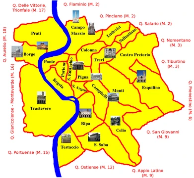
Sallustiano
Rione named for the ancient Gardens of Sallust.
Last updated
Where it is
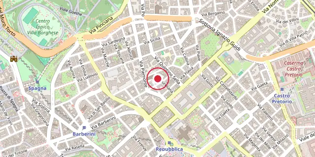
Coordinates: 41°54′25″N 12°29′42″E (41.9070, 12.4950) · Open in OpenStreetMap
Coordinates and connected clubs: the infobox of Wikipedia: Sallustiano (CC BY-SA 4.0). Map: drawn by Codexery from OpenStreetMap tiles.
Sallustiano is the 17th rione of Rome, Italy, designated R. XVII and located within Municipio I. Its name derives from the ancient Gardens of Sallust (Horti Sallustiani) that once occupied the area.
History
In the Augustan age, this area was part of the regio Alta Semita, Latin for 'high pathway'. The Horti Sallustiani, which gave the rione its name, were located here, along with the Temple of Venus Erycina situated between Via Piave and Via Calabria; this temple was considered as important as Sallust's villa, and its golden mirror on a blue background became the rione's coat of arms. Between Via Flavia and Via Servio Tullio stood a temple to the goddess Fortuna, while the circus of Flora probably lay between Via XX Settembre and Via Boncompagni.
The Sallustian obelisk, now in Piazza della Trinità dei Monti, was found in the Horti Sallustiani and likely adorned a private hippodrome of Sallust's villa rather than the circus's spina. Via Piave follows the former Via Salaria Nova, which exited from Porta Collina toward the demolished Porta Salaria. Nearby was an important sepulchral area including the funerary monument to Sulpicius Maximus, now in Piazza Fiume, and that of Cornelia, near the walls on Corso Italia.
In AD 410, the Visigoths under Alaric cut the aqueducts and plundered Sallust's villa, leaving it ruined and abandoned. A modest recovery came in the 16th century under Sixtus V, who opened the new Via Pia and restored water via the Acquedotto Felice, named after the pope himself. In 1608, Cardinal Scipione Borghese funded the construction of Santa Maria della Vittoria. Despite this, the rione—then part of Trevi—remained sparsely populated, with large green areas from villas such as Villa Barberini, Villa Mandosi, and Villa Cicciaporci.
This greenery vanished with the urbanization that followed the breach of Porta Pia, which opened in the short portion of walls belonging to the rione.
Geography
Sallustiano, like neighboring Ludovisi and Castro Pretorio, emerged at the end of the 19th century in an area between Via Pia (later Via XX Settembre) and Via Boncompagni, previously vineyards and gardens belonging to Trevi. Its road scheme is less rigid and severe than other rioni developed at the same time, with more variation in block shapes and street layouts, partly due to its small area. To the north, it borders Ludovisi along Via Friuli, Via Lucullo, Via Boncompagni, Via Calabria, and Piazza Fiume.
Eastward, the Aurelian Walls between Piazza Fiume and Porta Pia separate it from Quartiere Salario. Southward, Via XX Settembre marks the boundary with Castro Pretorio. Westward, Largo di Santa Susanna, Via di Santa Susanna, Via Giosuè Carducci, and Via Leonida Bissolati divide it from Trevi. The quiet Piazza Sallustio, the rione's only real square, lies at its center and still displays archaeological remains of the Horti Sallustiani.
The rione divides into two parts: one around Via Piave, Via Piemonte, and Via Antonio Salandra with moderate housing density, and the other up to Via Leonida Bissolati, almost uninhabited and concentrated with offices and ministries.
Places of interest
Notable buildings include Villino Boncompagni Ludovisi on Via Boncompagni; Palazzo Canevari on Largo Santa Susanna, a 19th-century liberty building (1873–81) by architect Raffaele Canevari, formerly the Royal Geologic Office; Villino Casati on Via Piemonte; Villino Levi on Via Boncompagni at Via Nerva; Villino Maccari on Via Sallustiana, a 20th-century building (1902) by Augusto Fallani for painter Cesare Maccari; Palazzo dell'Agricoltura on Via Venti Settembre, a 20th-century building (1908–1914) housing the Ministry of Agricultural, Food and Forestry Policies; Villino Macchi di Cèllere al Sallustiano on Via Piemonte, an 1887 building by Carlo Pincherle for the Macchi di Cèllere family; Villino Pignatelli and Villino Rasponi on Via Boncompagni at Via Piemonte; Villino Rattazzi on Via Boncompagni; Villino Rudinì on Via Quintino Sella, seat of the Japanese consular representative; Palazzo Fiat on Via Calabria, a 1924–1926 building in the Barocchetto Romano style by Enrico Del Debbio; Palazzo della Società Beni Stabili on Via Piemonte at Via Giosuè Carducci, a 1957 modernist building by Cesare Pascoletti; and Villa Spithover on Via Piemonte, a Neo-Renaissance building (1870) by Luca Carimini, later demolished for the Basilica di San Camillo de Lellis.
Churches include San Camillo de Lellis on Via Sallustiana, Santa Maria della Vittoria on Via Venti Settembre, and Sacro Cuore di Gesù on Via Piave. Archaeological sites include an archaic residence from the early 6th century BC discovered under Palazzo Canevari in 2013, the Horti Sallustiani on Piazza Sallustio, and Porta Salaria in the Aurelian walls, destroyed in 1921 for Via Piave. Museums include the Boncompagni Ludovisi Decorative Art Museum and the Museo storico dei bersaglieri.
More in Rioni of Rome
Sources
Compiled from Wikipedia and the sources listed below. Text from Wikipedia is available under CC BY-SA 4.0; this entry is adapted from it.
- Wikipedia: Sallustiano (CC BY-SA 4.0).
Spotted an error? Know more?
Reader corrections go straight into our review queue. Suggest an edit · How this site is sourced