Parnitha
Highest mountain in Attica, known as the 'lungs of Athens'.
Last updated

Stelios tsikas · CC BY-SA 4.0
Where it is
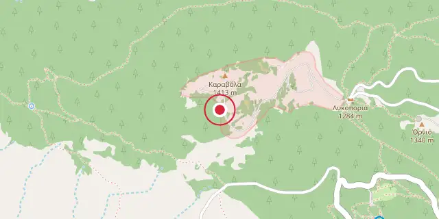
Coordinates: 38°10′23″N 23°43′01″E (38.1730, 23.7170) · Open in OpenStreetMap
Coordinates and connected clubs: the infobox of Wikipedia: Parnitha (CC BY-SA 4.0). Map: drawn by Codexery from OpenStreetMap tiles.
The highest point of the Attica peninsula is the Karavola summit, which reaches 1,413 meters on the lightly forested Parnitha range north of Athens.[1] In 1961, a national park was established on Parnitha, protecting much of the mountain as a habitat for wildfowl.[1] Parnitha's land area is roughly 250 square kilometers.[1]
Geography and history
In antiquity, several fortresses were built on the mountain for the defense of Attica and Classical Athens against the Boeotians.[2] Acharnes is 18 km south of the summit, while the center of Athens lies about 30 km further south.[1] Aleppo pine forests grow on all slopes below 1,000 meters, and these areas frequently face fire threats.[3] Greek Fir, grasses, and shrubbery dominate the vegetation above 1,000 meters.[3]
The Phyle fortress, located at 687 meters on Parnitha's western side, is one of several ancient fortifications that remain well-preserved today.[2] The Monastery of Kleiston, a Byzantine structure from the 13th century, is a significant later-period monument.[4]
What the cited sources add
A BBC report from June 2007 notes that the forests of Mount Parnitha are popular with Athenians wanting to escape the heat of the city.[5] The same BBC report states that the 2007 wildfire burned on the slopes and could be seen from Athens.[5] A 2015 article from protothema.gr describes Lake Beletsi as a small artificial lake created by accident in the Seventies during infrastructure construction.[6] The protothema.gr account adds that the lake is an important area for migratory birds, ducks and fish.[6]
A CNN report from August 2023 notes that a wildfire on Parnitha was still burning four days after its ignition.[7]
References
- Wikipedia, "Parnitha" (CC BY-SA 4.0), which cites: Parnitha National park, official site. (original not read by us) en.wikipedia.org
- Wikipedia, "Parnitha" (CC BY-SA 4.0), which cites: "Αρχαία Μνημεία", parnitha-np.gr (original not read by us) en.wikipedia.org
- Wikipedia, "Parnitha" (CC BY-SA 4.0), which cites: "Βλάστηση", parnitha-np.gr (original not read by us) en.wikipedia.org
- Wikipedia, "Parnitha" (CC BY-SA 4.0), which cites: "Μονή Κλειστών Χασία", eie.gr (original not read by us) en.wikipedia.org
- "Greek forest fire close to Athens", BBC, June 29, 2007. facts only, no text reused. news.bbc.co.uk
- "Beletsi, the beautiful accidental lake of Mt. Parnitha", protothema.gr, 9 January 2015. facts only, no text reused. en.protothema.gr
- Eleni Giokos, "A losing battle to save the lungs of Athens as wildfires grip Greece", CNN, August 27, 2023. facts only, no text reused. cnn.com
Each numbered sentence above was checked against the source it cites before publication. Sentences citing Wikipedia adapt text from the English Wikipedia article Parnitha (contributors), used under CC BY-SA 4.0; this entry is available under the same licence. Other sources were used for facts only; no text or images are copied from them.
More in National parks of Greece
Sources
Compiled from Wikipedia and the sources listed below. Text from Wikipedia is available under CC BY-SA 4.0; this entry is adapted from it.
- Wikipedia: Parnitha (CC BY-SA 4.0).
Spotted an error? Know more?
Reader corrections go straight into our review queue. Suggest an edit · How this site is sourced