Balkan Mountains
A major mountain range forming a natural barrier across Bulgaria.
Last updated
Where it is
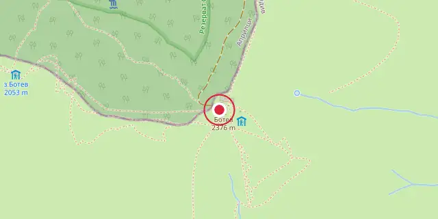
Coordinates: 42°43′01″N 24°55′01″E (42.7170, 24.9170) · Open in OpenStreetMap
Coordinates and connected clubs: the infobox of Wikipedia: Balkan Mountains (CC BY-SA 4.0). Map: drawn by Codexery from OpenStreetMap tiles.
The Balkan Mountains stretch across the eastern Balkan Peninsula in Southeastern Europe. Their conventional starting point is Vrashka Chuka, a peak on the Bulgaria–Serbia border.
From there, the range runs roughly 560 kilometers (350 miles)—first southeast along the border, then eastward through Bulgaria, acting as a natural divide between the country’s northern and southern halves—until it reaches the Black Sea at Cape Emine. The highest point is Botev Peak, standing at 2,376 meters (7,795 feet). The mountains give their name to the broader Balkans region.
Geography
Geologically, the range is a relatively young fold mountain chain, part of the vast Alp-Himalayan system. It consists of the main Balkan Chain and the Pre-Balkans to the north, while to the south it borders a series of eleven valleys known as the Sub-Balkan valleys. The range is divided into three sections within Bulgaria: the Western section (190 km, highest peak Midžor at 2,169 m), the Central section (207 km, containing Botev Peak), and the Eastern section (160 km, the lowest part, with Balgarka at 1,181 m). In much of the central and eastern parts, the mountain crest forms the watershed between rivers flowing to the Black Sea and those flowing to the Aegean Sea.
Bulgaria
A notable break in the range is the narrow Iskar Gorge, located north of Sofia, through which Bulgaria’s longest river, the Iskar, flows. The karst landscape has produced many caves, including Magura, which contains the most extensive post-Palaeolithic cave paintings in Europe, as well as Ledenika, Saeva dupka, and Bacho Kiro. The Belogradchik Rocks are a prominent rock formation in the west. Protected areas include Central Balkan National Park, Vrachanski Balkan, Bulgarka, and Sinite Kamani, along with several nature reserves.
Etymology
The mountains host most of Europe’s large mammals, such as brown bears, wolves, boar, chamois, and deer, and edelweiss grows in the Kozyata stena region. Historically, the range was known in antiquity as Haemus, from a Thracian word for mountain ridge, and Cape Emine derives from this name. The modern Slavic name Stara Planina, meaning "old mountain," was first recorded in the early 16th century. The Turkish name Balkan may ultimately come from a Persian word meaning "high house."
Lore & Background
The Balkan Mountains are a chain of fold mountains, relatively young on a geological time scale, forming part of the Alp-Himalayan chain. They can be divided into the main Balkan Chain and the Pre-Balkans to the north, while to the south they border the Sub-Balkan valleys, a row of 11 valleys running from the Bulgarian-Serbian border east to the Black Sea. The range consists of around 30 distinct peaks and is divided into three sections: the Western Balkan Mountains extend from Vrashka Chuka to the Pass of Arabakonak, with a total length of 190 kilometres (120 mi) and highest peak Midžor at 2,169 metres (7,116 ft); the Central Balkan Mountains run from Arabakonak to the Vratnik Pass, with a length of 207 kilometres (129 mi) and contain Botev Peak, the highest in the range at 2,376 metres (7,795 ft); the Eastern Balkan Mountains extend from the Vratnik Pass to Cape Emine, with a length of 160 kilometres (99 mi) and highest peak Balgarka at 1,181 metres (3,875 ft), forming the lowest part.
In Antiquity and the Middle Ages the mountains were known as Haemus, derived from a Thracian word saimon, meaning 'mountain ridge'. The name of the place where the range meets the Black Sea, Cape Emine, is derived from Aemon. Two folk etymologies from Greek mythology connect the name Haemus to the word haima (αἵμα), meaning 'blood'—one involving the battle between Zeus and Typhon, the other involving King Haemus and his wife Rhodope being transformed into mountains.
Reader's Guide
The Balkan Mountains are significant for their role as a natural barrier and watershed. In much of the central and eastern sections, the summit forms the watershed between the drainage basins of the Black Sea and the Aegean. The mountains are crossed by Bulgaria's longest river, the Iskar, which forms the Iskar Gorge.
The karst relief has produced numerous caves, including Magura, featuring the most important and extended European post-Palaeolithic cave painting, as well as Ledenika, Saeva dupka, and Bacho Kiro. Notable rock formations include the Belogradchik Rocks in the west. The range contains several important protected areas: Central Balkan National Park, Vrachanski Balkan, Bulgarka, and Sinite Kamani, as well as nature reserves like Chuprene and Kozyata stena.
The mountains are remarkable for their flora and fauna—edelweiss grows there in the region of Kozyata stena, and most of Europe's large mammals inhabit the area, including the brown bear, wolf, boar, chamois and deer. The mountains are crossed by 20 passes and two gorges, with paved roads at passes including Petrohan Pass, Iskar Gorge, Vitinya Pass, Shipka Pass, and the Pass of the Republic, among others. Notable waterfalls include Raysko Praskalo, the highest waterfall in the Balkans, and on the Serbian side, discoveries like Kopren at 103.5 m (340 ft) in 2011 and Kaluđerski Skokovi at 232 m (761 ft) in 2012.
Ranked in
Also in the Codexery
More in Mountains And Mountain Ranges
Sources
Compiled from Wikipedia and the sources listed below. Text from Wikipedia is available under CC BY-SA 4.0; this entry is adapted from it.
- Wikipedia: Balkan Mountains (CC BY-SA 4.0).
Spotted an error? Know more?
Reader corrections go straight into our review queue. Suggest an edit · How this site is sourced