Meridian (geography)
A line of longitude connecting points of equal longitude.
Last updated
A meridian in geography and geodesy is the locus connecting points of equal longitude, forming a line of longitude that runs from pole to pole. It is a fundamental reference for mapping, navigation, and timekeeping, with the prime meridian at Greenwich, England, serving as the global standard for zero degrees longitude. On a spherical model of Earth, a meridian is a great semicircle; on a spheroidal or ellipsoidal model, such as the WGS 84, it is half of a north-south great ellipse. The length of a meridian is twice the length of an Earth quadrant.
The term derives from the Latin meridies, meaning "midday," as the subsolar point crosses a given meridian at solar noon, and the Sun crosses the celestial meridian at the same time; this root also gives rise to the terms a.m. and p.m. Historically, Eratosthenes set the first prime meridian around 200 BCE. By the early modern era, multiple locations, notably Paris and Greenwich, were used as prime meridians, causing inconsistency in coordinates and local times.
The 1884 International Meridian Conference in Washington, D.C., attended by twenty-six countries, established a single prime meridian passing through Greenwich, set at zero degrees longitude, with two longitude directions up to 180 degrees (east positive, west negative). The antimeridian, at 180 degrees longitude near the International Date Line, forms the opposite half of the circle. The geodetic prime meridian, since the adoption of WGS 84, lies 102.478 meters east of the historic astronomic prime meridian marked at Greenwich. The magnetic meridian is an imaginary line connecting the magnetic poles, with a compass needle aligning parallel to it; the angle between the magnetic and true meridian is magnetic declination.
Quick Facts
- Key concept
- Line of longitude connecting points of equal longitude
- Prime meridian
- Greenwich, England (IERS Reference Meridian)
- Etymology
- From Latin 'meridies' meaning 'midday'
- Related terms
- a.m. (ante meridiem), p.m. (post meridiem)
Facts from the source article.
Lore & Background
A meridian, in geography and geodesy, is the line connecting all points that share the same longitude, representing the angular distance east or west of a prime meridian. It is a coordinate line for longitude, with a point’s position along it defined by its latitude, measured north or south of the Equator. On map projections like Mercator or Gall-Peters, each meridian is perpendicular to all circles of latitude. On a spherical Earth model, a meridian is a great semicircle; on a spheroidal or ellipsoidal model, it is half of a north-south great ellipse.
The length of a meridian is twice the length of an Earth quadrant, equal to a specific value on the modern WGS 84 ellipsoid. The term derives from the Latin meridies, meaning “midday,” because the subsolar point crosses a given meridian at solar noon, and the Sun crosses the celestial meridian at the same time. Historically, the first prime meridian was set by Eratosthenes in 200 BCE. By the early modern era, multiple locations were used, with Paris and Greenwich being the most acknowledged.
The International Meridian Conference of 1884 established Greenwich as the single prime meridian (0°), with longitude measured east and west up to 180°. The antimeridian, at 180° longitude, lies opposite Greenwich near the International Date Line. The geodetic prime meridian under WGS84 is now 102.478 meters east of the older astronomic position at Greenwich. The magnetic meridian is an imaginary line connecting the magnetic poles, and the angle between it and the true meridian is magnetic declination.
The Geographical Framework of Latitude and Longitude
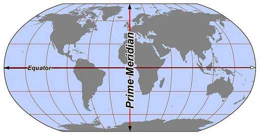
The standard geographical hemispheres rely on two primary sets of markers: latitudinal lines running north to south, and longitudinal lines running east to west. The Equator serves as the dividing line between the Northern and Southern Hemispheres, while the Prime Meridian — the zero-degree line of longitude — separates the Eastern and Western Hemispheres. Together, these two reference lines create a four-part grid that underpins virtually every world map and most global statistical analyses.
The north-south division is particularly significant because latitude directly correlates with climate zones, seasonal variation, and the angle at which sunlight strikes the surface. The east-west division, anchored to the Prime Meridian, has historically carried cultural and political weight, as it was established by international agreement rather than by any natural feature. Both divisions are essential tools when researchers seek to understand how continents and oceans are distributed across the globe, and they form the backbone of discussions about the Global North and Global South, as well as the broader East-West dichotomy in both physical and human geography.
Reader's Guide
The meridian is a foundational concept in geography and geodesy, providing the coordinate system for longitude that enables precise mapping, navigation, and timekeeping. The meridian's role extends to defining the Western and Eastern Hemispheres, and its antimeridian near the International Date Line governs calendar date changes. Modern systems like WGS84 have refined the meridian's position, but its core function remains unchanged.
The meridian also underpins the measurement of Earth rotation and the calculation of latitude via meridian passage of celestial objects. The distinction between true meridian and magnetic meridian is crucial for compass navigation, with magnetic declination being the angle between them. Standard meridians are used for time zones, with most countries adopting one of the 24 meridians closest to their position, though some use offsets of 30 or 45 minutes.
Frequently Asked Questions
What is a meridian in geography?
A meridian is a line of longitude that links every point sharing the same longitude value, stretching continuously from the North Pole to the South Pole. It forms one of the essential reference lines used to chart positions on Earth's surface.
What is the prime meridian and where is it located?
The prime meridian is the zero-degree longitude line established at Greenwich, England, and it serves as the global reference point from which all other longitudes are measured east or west. It is formally designated as the IERS Reference Meridian.
Also in the Codexery
More in Lines & Hemispheres
Sources
Compiled from Wikipedia and the sources listed below. Text from Wikipedia is available under CC BY-SA 4.0; this entry is adapted from it.
- Wikipedia: Meridian (geography) (CC BY-SA 4.0).
Spotted an error? Know more?
Reader corrections go straight into our review queue. Suggest an edit · How this site is sourced