Yamanashi Prefecture
Landlocked prefecture in central Honshu, home to Mount Fuji.

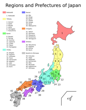
Yamanashi Prefecture sits in the Chūbu region of Honshu, one of Japan’s eight landlocked prefectures. As of February 2025, its population is 787,592, spread across 4,465 square kilometers. The capital, Kōfu, is also the largest city; other major urban centers include Kai, Minamiarupusu, and Fuefuki. Yamanashi shares borders with Saitama, Nagano, Shizuoka, Kanagawa, and Tokyo. Most residents live in the central Kōfu Basin, ringed by the Akaishi Mountains, and about 27 percent of the prefecture’s land falls within Natural Parks. Mount Fuji, Japan’s highest peak and a national symbol, straddles the border with Shizuoka.
The name Yamanashi means “Pear Mountain,” referring to a local variety of Asian pear (*Pyrus pyrifolia*).
In prehistoric times, the area followed the typical Japanese progression from Jōmon hunting and gathering through Yayoi rice cultivation to the formation of villages and regional polities. The Maruyama and Choshizuka burial mounds on Sone Hill in what is now southern Kōfu date to the late 4th century, suggesting that the people there held considerable power. During the Heian period, the region became known as Kai Province.
Among the many lineages of the Kaigenji clan, the Takeda, Ogasawara, and Nanbu families thrived. In the 16th century Sengoku period, Takeda Shingen rose to daimyō status, building Tsuzuji Mansion and Yōgai Castle in Kōfu as bases for his attempt to unify Japan. After his death in 1582, Kai Province passed to the Oda and Toyotomi clans, then to the Tokugawa shogunate in the Edo period. Under the shogunate, the Kōfu clan controlled central and western Yamanashi, while the Yamura clan governed the east. In 1724, the shogunate took direct control. The Kōshū Kaidō highway and Fuji River transport brought goods, materials, and culture into the region. By the mid-19th century, growing instability across Japan set the stage for the 1868 Meiji Restoration.
During the Boshin War, the Battle of Kōshū-Katsunuma on March 29, 1868, pitted pro-Imperial forces against Tokugawa loyalists just before the Imperial army marched on Edo Castle. Kōfu Castle had already been seized by troops supporting Emperor Meiji. The province was renamed Kōfu Prefecture in 1869, then Yamanashi Prefecture in 1871; the November 20 anniversary of this change is now Prefectural Citizen’s Day. Early Meiji policies promoted sericulture, silk weaving, and winemaking. In 1903, after seven years of construction—including a nearly three-mile tunnel at Sasago Pass—the Chūō Railway Line reached Kōfu from Hachiōji and central Tokyo, shortening travel times to the capital and Yokohama and reshaping local industry and culture. Farming remained small-scale until land reforms took hold. From the 1920s, disputes between landowners and tenants became common. The Minobu Railway Line opened in 1926, ending Fuji River transport, and the Koumi Line connected Kobuchizawa to Kiyosato in 1933, opening up remote highlands on Mount Yatsugatake’s slopes.
Kōfu suffered heavy damage in a major air raid on July 6, 1945. After the war, occupation-era land reforms increased the number of individual farms and promoted fruit growing and viticulture. Dairy farming, introduced by American Paul Rusch, took root in the highland pastures around Kiyosato—first with limited success in 1946, then more steadily from 1951. Small manufacturing and commerce expanded rapidly during Japan’s postwar economic boom. The 1982 opening of the Chūō Expressway spurred growth in services, logistics, and tourism. In the 1990s, rising car ownership, out-of-town shopping, and better links to Tokyo led to declining commercial activity and land values in central Kōfu. To counter this, the prefectural government launched a city center revitalization plan in 2008, focusing on attractions such as redeveloped land north of Kōfu Station, Maizuru Castle Park, and new residential, cultural, and government facilities.
- Population
- 787,592 (as of 1 February 2025)
- Area
- 4,465 km² (1,724 sq mi)
- Capital
- Kōfu
- Region
- Chūbu, Honshu, Japan
Verified Timeline
Lore & Background
Yamanashi Prefecture corresponds to the historical Kai Province, created during the Heian period. During the Sengoku period of the 16th century, Takeda Shingen attained the status of daimyō and built Tsuzuji Mansion and Yōgai Castle in Kōfu. After Takeda's death in 1582, Kai-no-Kuni came under the control of the Oda and Toyotomi clans before being subsumed into the Tokugawa shogunate during the Edo period. In 1724 the area came under the direct control of the Shogunate. During the Boshin War, the Battle of Kōshū-Katsunuma on 29 March 1868 was a significant battle between pro-Imperial and Tokugawa shogunate forces. The province was renamed Kōfu Prefecture in 1869 and then Yamanashi Prefecture in 1871. The anniversary of this event on November 20, 1872, is now celebrated as Prefectural Citizen's Day in Yamanashi.
Reader's Guide
Yamanashi Prefecture's significance lies in its unique geography and economy. As one of only eight landlocked prefectures, its central Kōfu Basin is surrounded by the Akaishi Mountains, with 27% of its total land area designated as Natural Parks. The prefecture is a top domestic producer of grapes, peaches, plums, and wine. Roughly 40% of the mineral water bottled in Japan comes from Yamanashi, mainly from around the Southern Alps, Mount Fuji, and Mitsutōge areas. It hosts the headquarters of FANUC, manufacturer of factory automation systems, in Oshino. The SCMaglev test track, a completed 42.8 km section of the planned Chūō Shinkansen, runs under mountains in the eastern part of the prefecture, with a station planned south of Kōfu. The prefecture's population peaked at roughly 890,000 around the turn of the millennium and has since declined.
Did You Know?
- The name Yamanashi Prefecture literally means 'Pear Mountain,' referring to a local Japanese cultivar of the Asian pear, Pyrus pyrifolia.
- Mount Fuji, the tallest mountain in Japan at 3,776 m, is partially located in Yamanashi Prefecture on the border with Shizuoka Prefecture.
- Yamanashi is one of only eight landlocked prefectures in Japan.
- Roughly 40% of the mineral water bottled in Japan comes from Yamanashi.
- The SCMaglev test track in Yamanashi is a completed 42.8 km section of the planned Chūō Shinkansen.
Frequently Asked Questions
Who is Yamanashi Prefecture?
Yamanashi is a landlocked prefecture in central Honshu, Japan, sitting within the Chūbu region. It is most widely recognized as the home of Mount Fuji and as one of the nation's premier fruit-growing areas.
What are Yamanashi Prefecture's signature 'powers' or claims to fame?
Its crown jewel is Mount Fuji, which defines the prefecture's identity and draws visitors worldwide. It also ranks among Japan's top producers of grapes, peaches, and plums, and it hosts the SCMaglev test track for next-generation rail research.
Where exactly is Yamanashi Prefecture located and what is its capital?
It sits entirely inland in the Chūbu region of Honshu, bordered by neighboring prefectures with no access to the sea. Kōfu serves as both the administrative capital and the largest city.
How large is Yamanashi Prefecture in terms of area and population?
The prefecture spans roughly 4,465 square kilometers (about 1,724 sq mi). As of early 2025, its resident population stands at approximately 787,592 people.
Why does Yamanashi Prefecture matter to the broader picture of Japan?
It is culturally pivotal as the guardian of Mount Fuji, a UNESCO-recognized landmark, and economically significant through its fruit, wine, and mineral-water industries. It also plays a forward-looking role in transportation R&D via the SCMaglev test line.
More in Japanese Prefectures 1-24
Spotted an error? Know more?
This is a living reference — every entry is fact-audited, and reader corrections feed straight into our audit queue. Suggest an edit · See this site's audit record