Tottori Prefecture
Japan's least populous prefecture, home to its largest sand dunes.

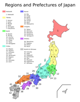
Tottori Prefecture sits in the Chūgoku region on the island of Honshu. It is Japan’s least populous prefecture, with 538,525 residents as of 2023, and spans 3,507.13 square kilometers. Its capital and largest city is Tottori; other major cities include Yonago, Kurayoshi, and Sakaiminato. The prefecture is known for the Tottori Sand Dunes—Japan’s largest dune system—and Mount Daisen, the highest peak in the Chūgoku Mountains. It shares borders with Shimane to the west, Hiroshima to the southwest, Okayama to the south, and Hyōgo to the east. Despite its small population, Tottori households consume more coffee per household than any other prefecture in Japan.
The name “Tottori” comes from two kanji: 鳥 (bird) and 取 (to get). Early residents caught abundant waterfowl in the area. The name first appears in the *Nihon shoki* in 213 AD, during Emperor Suinin’s 23rd year. An elder from Izumo, Yukuha Tana, presented a swan to the emperor. The imperial prince Homatsu-wake, then 30 years old and unable to speak, played with the swan and learned to talk. Yukuha Tana was richly rewarded and granted the title Tottori no Miyakko.
Human settlement in Tottori dates back to the Jōmon period (14,000–300 BC). The prefecture holds the largest known Yayoi-period settlement (300 BC–250 AD) in Japan: the Mukibanda Yayoi remains, in the foothills of Mount Daisen across the cities of Daisen and Yonago. Numerous kofun burial mounds from the Kofun period (250–538) dot the landscape. In 645, under the Taika reforms, the area became two provinces: Hōki and Inaba.
During the Genpei War (1180–1185), Tottori served as a base for anti-Taira forces, particularly at the temples Daisen-ji and Sanbutsu-ji. By the Kamakura period (1185–1333), shōen estates were established to support the imperial court and temples. In the Sengoku period (15th–17th centuries), clans such as the Yamana controlled the region. After the Battle of Sekigahara in 1600, the Tokugawa shogunate placed the Ikeda clan at Tottori Castle, and they governed the area throughout the Edo period (1603–1868), using its resources to support the shogunate.
The two provinces remained until the Meiji Restoration in 1868. Tottori Prefecture’s boundaries were set in 1888. In the 20th century, after Japan’s occupation of Korea and Taiwan and the establishment of Manchukuo in 1932, Tottori’s Sea of Japan harbors became busy transit points for goods with colonial territories. In 1943, a magnitude 7.2 earthquake—the Tottori earthquake—destroyed 80% of Tottori city and heavily damaged the surrounding area. After World War II, land reform boosted agricultural production.
Tottori Sand Dunes are Japan’s only large dune system. As of April 2012, 14% of the prefecture’s land was designated as natural parks: Daisen-Oki and Sanin Kaigan National Parks; Hiba-Dōgo-Taishaku and Hyōnosen-Ushiroyama-Nagisan Quasi-National Parks; and Misasa-Tōgōko, Nishi Inaba, and Okuhino Prefectural Natural Parks. Mount Misumi lies in the former town of Mochigase, merged into Tottori city in 2004.
Four cities make up the prefecture: Tottori, Yonago, Kurayoshi, and Sakaiminato. Towns and villages are organized into districts. Tottori remains Japan’s least populated prefecture by census data.
The economy is heavily agricultural, shipping products like nashi pears, nagaimo yams, Japanese scallions, negi, and watermelons to major cities. It is also a major rice producer.
Historically, the region had diverse dialects. Today, standard Tokyo Japanese is common, but several local dialects survive, grouped with Western Japanese, including Chugoku and Umpaku dialects.
Sports: Gainare Tottori (football/soccer) is based in Yonago.
Education: Universities include Tottori University and Tottori University of Environmental Studies. Colleges include Tottori College and Tottori College of Nursing.
Notable places: In Tottori City—Jinpūkaku (a late Meiji residence) and the Tottori Sand Dunes. In Daisen—Mount Daisen (1,729 m). In Daisen and Yonago—the Mukibanda Yayoi remains. In Yonago and Sakaiminato—Nakaumi, a brackish lake and Japan’s fifth largest. In Misasa—Misasa Onsen and Sanbutsu-ji (a Heian-period temple, National Treasure). In Sakaiminato—Kitarō Road (dedicated to Shigeru Mizuki’s *GeGeGe no Kitaro* manga) and Lake Koyama. In Iwami—Uradome Coast, a scenic ria inlet. In Chizu—the Ishitani Residence, an Edo-period family home and National Treasure.
- Capital
- Tottori
- Population
- 538,525 (2023)
- Area
- 3,507.13 km²
- Region
- Chūgoku, Honshu
- Known for
- Tottori Sand Dunes, Mount Daisen, largest coffee consumer per household in Japan
Verified Timeline
Lore & Background
The name 'Tottori' first appears in the Nihon shoki in the 23rd year of Emperor Suinin (213 AD). An elder from Izumo, Yukuha Tana, presented a swan to the emperor, and the imperial prince Homatsu-wake, who was 30 and unable to speak, played with the swan and learned to speak. Yukuha Tana was granted the title Tottori no Miyakko. The area was settled very early, with remains from the Jōmon period (14,000–300 BC). The prefecture contains the largest known Yayoi period (300 BC–250 AD) settlement in Japan, the Mukibanda Yayoi remains, in the foothills of Mount Daisen. In 645, under the Taika reforms, the area became two provinces, Hōki and Inaba. During the Genpei War (1180–1185), Tottori became a base for anti-Taira forces at Daisen-ji and Sanbutsu-ji. After the Battle of Sekigahara in 1600, the Tokugawa shogunate installed the Ikeda clan at Tottori Castle, which controlled the area throughout the Edo period (1603–1868). The boundaries of Tottori Prefecture were established in 1888. In 1943, a magnitude 7.2 earthquake destroyed 80% of the city of Tottori.
Reader's Guide
Tottori Prefecture is heavily agricultural, shipping nashi pears, nagaimo yam, Japanese scallion, negi, and watermelon to major cities, and is a major rice producer. It has the lowest population in Japan but the biggest coffee consumption per household. The Tottori Sand Dunes are Japan's only large dune system. As of 1 April 2012, 14% of the prefecture's land was designated as Natural Parks, including Daisen-Oki and Sanin Kaigan National Parks. Notable sites include Jinpūkaku in Tottori City, the Mukibanda Yayoi remains in Daisen and Yonago, Nakaumi lake (fifth largest in Japan) between Yonago and Sakaiminato, Misasa Onsen and Sanbutsu-ji (a National Treasure) in Misasa, Kitarō Road in Sakaiminato, Uradome Coast in Iwami, the Ishitani Residence (a National Treasure) in Chizu, and Tottori Hanakairo-Flower Park (largest flower park in Japan) in Nanbu. The prefecture's symbol, adopted in 1968, combines the first mora 'と' with a flying bird, symbolizing peace, liberty, and advancement.
Did You Know?
- Tottori Prefecture has the lowest population of any Japanese prefecture, at 538,525 as of 2023.
- The name 'Tottori' first appears in the Nihon shoki in 213 AD, when an elder named Yukuha Tana presented a swan to the emperor.
- The 1943 Tottori earthquake, magnitude 7.2, destroyed 80% of the city of Tottori.
- Tottori Prefecture has the biggest coffee consumption per household in Japan.
- The Mukibanda Yayoi remains are the largest known Yayoi period settlement in Japan.
Frequently Asked Questions
Who is Tottori Prefecture?
Tottori is a prefecture situated in the Chūgoku region of Honshu, Japan, with Tottori City as its capital and largest urban center. It holds the unique distinction of being the least populous of all 47 Japanese prefectures.
What are Tottori Prefecture's signature powers?
Its headline features are the Tottori Sand Dunes, the largest dune system anywhere in Japan, and Mount Daisen, the highest peak in the Chūgoku Mountains. It also claims the record for the highest per-household coffee consumption in the country.
How does Tottori Prefecture's story end?
Because Tottori is a living, ongoing place rather than a finished narrative, its arc has no fixed ending. As of 2023 it remains an active prefecture of roughly 538,525 residents spread across 3,507 square kilometers, still writing its own chapter.
Why is Tottori Prefecture important to the overall lineup?
It stacks multiple national superlatives—smallest population, biggest sand dunes, top coffee drinkers per household—into a single entry, giving it a highly recognizable identity among Japan's 47 prefectures.
What is Tottori Prefecture's main weakness?
With just over half a million people, it has the smallest demographic footprint in the country, which can constrain economic scale, infrastructure funding, and political weight relative to denser neighboring prefectures.
More in Japanese Prefectures 1-24
Spotted an error? Know more?
This is a living reference — every entry is fact-audited, and reader corrections feed straight into our audit queue. Suggest an edit · See this site's audit record