
The Lewis and Clark Expedition
U.S. expedition to explore the Louisiana Purchase and reach the Pacific.

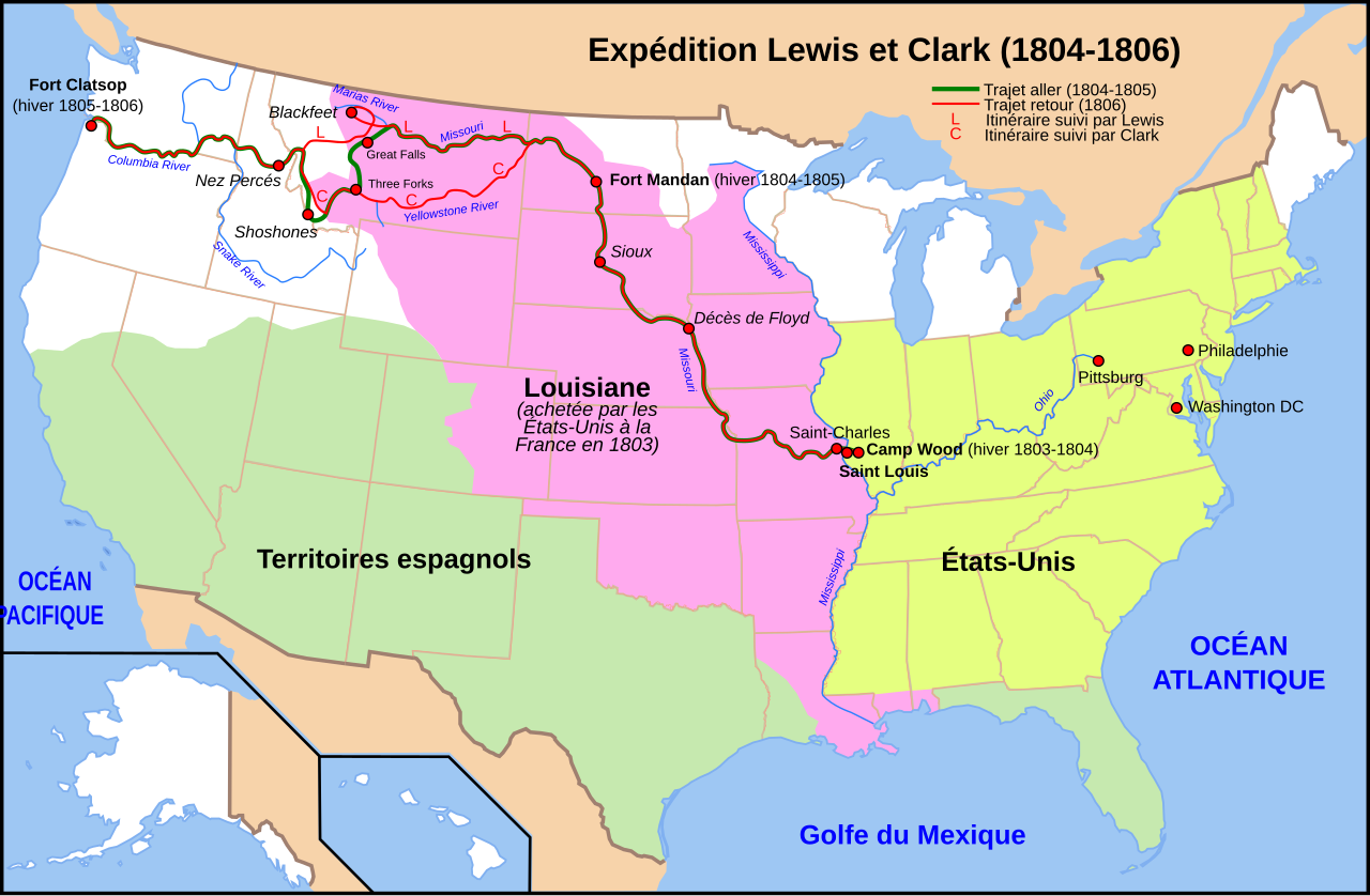
Carte Lewis-Clark Expedition-fr.svg : Sardon derivative work: rowanwindwhistler · CC BY-SA 3.0
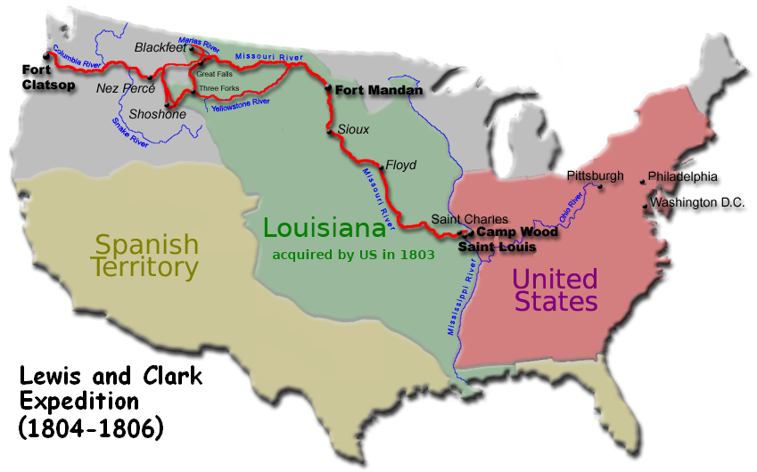
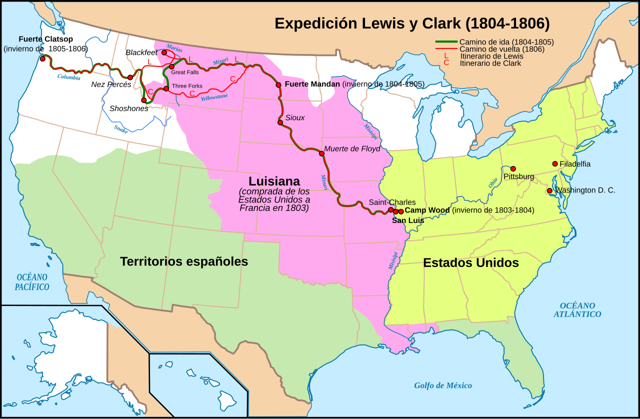
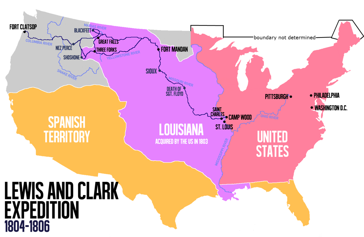
In 1803, shortly after the Louisiana Purchase, President Thomas Jefferson commissioned an expedition to explore and map the vast new western territory. The group, called the Corps of Discovery, was made up of U.S. Army soldiers and civilian volunteers. Captain Meriwether Lewis and his close friend Second Lieutenant William Clark led the mission. On May 14, 1804, Clark and about thirty others left from Camp Dubois in Illinois. They met Lewis and ten more members in St. Charles, Missouri, and then headed up the Missouri River. The expedition crossed the Continental Divide near Lemhi Pass, eventually reached the Columbia River, and arrived at the Pacific Ocean in 1805. The return trip started on March 23, 1806, from Fort Clatsop in Oregon, and ended six months later on September 23.
Jefferson wanted the expedition to find a practical water route across the continent for trade, avoiding the hot desert southwest. He also aimed to establish an American presence in the new lands before European powers could make claims. Secondary goals included documenting the region’s plants, animals, and geography, and building trade relationships with Native American tribes. The explorers returned to St. Louis with maps, sketches, and journals for the president.
Jefferson had long been interested in exploring the West. As minister to France in the 1780s, he discussed a Pacific trip with John Ledyard. He also read Captain James Cook’s account of his third voyage and Le Page du Pratz’s *The History of Louisiana*, which influenced his decision. Like Cook, Jefferson wanted a practical route to the Pacific. Alexander Mackenzie had already crossed North America north of Mexico in 1793, reaching the Pacific coast of British Columbia twelve years before Lewis and Clark. Mackenzie’s 1801 book *Voyages from Montreal* warned Jefferson that Britain planned to control the Columbia River fur trade, which pushed Jefferson to act quickly.
To prepare, Jefferson sent Lewis to Philadelphia in 1803 for training. Lewis studied medicinal cures with Dr. Benjamin Rush, learned navigational instruments from astronomer Andrew Ellicott, and was taught by Benjamin Smith Barton how to preserve plant and animal specimens. Robert Patterson helped him compute latitude and longitude, and Caspar Wistar covered fossils. Lewis already had a strong aptitude for learning, especially from Jefferson’s own library on North American geography at Monticello. Jefferson chose Lewis because he combined scientific knowledge in botany, natural history, mineralogy, and astronomy with the toughness, prudence, woodsman skills, and familiarity with Native American ways needed for the journey.
Jefferson asked Congress for funding two years into his presidency. He did not hide the expedition from Spanish, French, or British officials but gave different reasons for it. Due to poor relations with the Federalist Party, he used a secret message to request money. Congress approved $2,324 for supplies and food, which Lewis managed. Lewis then invited William Clark to co-lead. The expedition’s main goal was not scientific research, though it made notable contributions to science. Among the supplies purchased by Israel Whelen in Philadelphia were 193 pounds of portable soup, 130 rolls of pigtail tobacco, 30 gallons of strong spirit of wine, Native American presents, medical supplies, mosquito netting, and oilskin bags.
- field
- Exploration
- nationality
- United States
- known_for
- First U.S. overland expedition to the Pacific coast and back
Quick Facts
- Map Size
- 350px
- Date
- 1804 · 05 · 14 · 1806 · 09 · 23
- Duration
- 862 days
- Motive
- Explore the 1803 Louisiana Purchase
- Organizers
- U.S. President Thomas Jefferson
- Participants
- Corps of Discovery: Lewis, Clark, 40 men, and one woman (Sacajawea)
- Deaths
- 1 – Charles Floyd, August 1804 near Sioux City, Iowa
Facts from the source article.
Lore & Background
Secondary objectives were scientific, economical, and humanitarian: to document biodiversity, topography, and geography, and to establish trade relations with Native American tribes. Jefferson's main goal was to find 'the most direct and practicable water communication across this continent, for the purposes of commerce.'
Jefferson had long been interested in exploring the western frontier, influenced by accounts of explorers such as Captain James Cook and Le Page du Pratz. Alexander Mackenzie's earlier crossing of North America informed Jefferson of British intent to control the fur trade, convincing him of the importance of securing the territory. Lewis was sent to Philadelphia to study under Benjamin Rush, Andrew Ellicott, Benjamin Smith Barton, Robert Patterson, and Caspar Wistar. The expedition carried a keelboat built near Pittsburgh, a Newfoundland dog named Seaman, and various supplies including portable soup, pigtail tobacco, and a Girandoni air rifle. The expedition traveled up the Missouri River to its headwaters, then to the Pacific via the Columbia River. They returned to St. Louis to report findings to President Jefferson via maps, sketches, and journals.
Reader's Guide
The Lewis and Clark Expedition holds significance as the first U.S. government-sponsored exploration of the vast territory acquired through the Louisiana Purchase. Its primary legacy lies in mapping a route to the Pacific Ocean and establishing a formal American presence in the Northwest, which helped counter European claims. The expedition also documented the region's biodiversity, topography, and geography, though scientific research was not the main goal. By distributing Indian Peace Medals and demonstrating military firepower, the Corps sought to assert U.S. sovereignty over Native American tribes along the Missouri River. The expedition's journals, maps, and sketches provided the U.S. government with crucial information about the resources and peoples of the West. The route may have been influenced by the purported transcontinental journey of Moncacht-Apé about a century earlier, as Jefferson had a copy of Le Page's book detailing that itinerary. The expedition's return to St.
Did You Know?
- Lewis bought a Newfoundland dog named Seaman, the only animal to complete the entire trip.
- The expedition carried a .46 caliber Girandoni air rifle with a 20-round tubular magazine.
- The US mint prepared special silver medals called Indian Peace Medals for distribution to tribes.
The Chronological Arc of a Multi-Year Undertaking
This five-year window frames the expedition not as a single dramatic crossing but as a sustained, multi-year undertaking. The expedition's duration across these years underscores that it was a logistical and organizational effort as much as a geographic one, requiring sustained coordination over multiple seasons before the team could complete its objective and return. The timeline thus reveals an expedition shaped by patience, planning, and the slow accumulation of progress across an entire half-decade.
The American West as a Corridor of Discovery
The defining geographic descriptor of the expedition is that it traveled through the American West. This phrasing is significant because it positions the journey not as a simple east-to-west transit but as a passage through a vast, largely uncharted region that constituted the western portion of the young nation. The fact that the timeline is organized as a progression through this region rather than a single point of arrival implies that the expedition's purpose was as much about the journey itself, the observations made along the way, as it was about reaching any particular terminus. The American West, in this context, was not merely a destination but a corridor of discovery that the expedition traversed over multiple years.
The Journals as a Living Historical Record
Among the most important artifacts of the Lewis and Clark Expedition are the journals that documented the journey. These journals are preserved and made accessible through an online resource titled Journals of the Lewis and Clark Expedition Online, indicating that the written record of the trip has been digitized for broader public access. The existence of these journals tells us that the expedition was not merely a physical crossing of the American West but also a deliberate act of documentation. The fact that these journals survive and are available online speaks to their historical importance and to the careful record-keeping that accompanied the journey. They represent the primary voice of the expedition, offering a day-by-day account that transforms a sequence of dates into a lived narrative of exploration through the western territories.
Encampments and the Rhythm of the Journey
The timeline of the expedition reveals that the journey was punctuated by specific encampments, periods where the team stopped, rested, and regrouped. This four-day pause during the early phase of the western passage illustrates that the expedition was not a continuous sprint but a rhythm of movement and rest. The specificity of the dates, spanning four days at a named location, suggests that these encampments were significant enough to be recorded as distinct events in the overall timeline. These encampments served as the structural units around which the broader journey was organized.
Common Misconceptions (Editorial)
Some people believe the Lewis and Clark Expedition was solely a military or exploratory mission, but the facts show that secondary objectives included scientific, economic, and humanitarian goals like documenting biodiversity and establishing trade relations with Native Americans. Another common misconception is that the expedition’s main purpose was to simply reach the Pacific, but President Jefferson’s primary goal was actually to find a direct water route across the continent for commerce.
Why It Matters (Editorial)
The Lewis and Clark Expedition endures as a defining moment in American exploration because it transformed vague geographical assumptions into precise maps and scientific records of the West. Its blend of military discipline, diplomatic outreach to Native tribes, and scientific curiosity set a lasting model for how the United States would engage with its expanding frontier.
Gallery
Frequently Asked Questions
Who is The Lewis and Clark Expedition?
It is the Corps of Discovery, a hand-picked team of U.S. Army personnel and civilian volunteers led by Captain Meriwether Lewis and his close friend Second Lieutenant William Clark. They are best known as the first American party to travel overland from the Mississippi region to the Pacific Coast and return.
What is The Lewis and Clark Expedition's role in the Great Explorers canon?
Their core mission was to survey, map, and document the vast Louisiana Purchase territory on behalf of the young United States. They also sought a practical western trade route and a way to assert American sovereignty across the continent.
Why is The Lewis and Clark Expedition important?
It delivered the first thorough American geographic and scientific survey of the continental interior, from the Great Plains to the Pacific. Their recorded observations of flora, fauna, Indigenous peoples, and the Continental Divide remain a cornerstone of U.S. western history.
More in Great Explorers 1-22
Spotted an error? Know more?
This is a living reference — every entry is fact-audited, and reader corrections feed straight into our audit queue. Suggest an edit · See this site's audit record