Janos, Chihuahua
Spanish presidio town in Chihuahua, key in Apache conflicts.
Last updated

via Wikipedia: Janos, Chihuahua · see source
Where it is
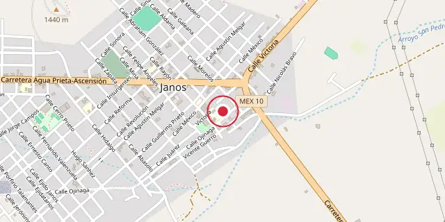
Coordinates: 30°53′17″N 108°11′24″W (30.8880, -108.1900) · Open in OpenStreetMap
Coordinates and connected clubs: the infobox of Wikipedia: Janos, Chihuahua (CC BY-SA 4.0). Map: drawn by Codexery from OpenStreetMap tiles.
Janos is a town in the northern Mexican state of Chihuahua that serves as the municipal seat for the Janos Municipality. As of 2010, the town had a population of 2,738.
It was possibly the site of a Franciscan mission established about 1640 and destroyed by Indian attack in the 1680s. In 1686, the Spanish established a fort in Janos, which became a key element in the Spanish attempt to suppress raids and attacks by the Apache people. Several hundred Apaches often lived near the presidio during the late 18th and early 19th centuries.
History
Franciscan missionary Alonso de Benavides, in his Memorial of 1630, listed the Janos and Suma among the tribes along the caravan route between Spanish settlements in Mexico and New Mexico. A mission called Nuestra Señora de la Soledad de los Janos was established in 1640 to Christianize these and other Native American groups, though its initial location is uncertain—possibly near the future town of Janos or near El Paso, Texas. In the 1680s, an uprising by the Suma, Janos, and other tribes destroyed the mission.
The Jocomes, a related people, also became prominent near Janos. In 1686, the Spanish governor ordered Captain Juan Fernández de la Fuente to establish a presidio at Janos, named Presidio de San Felipe y Santiago de Janos. The Franciscan mission was re-established among the Janos and Jocomes in 1717.
In 1692, the Apache were recorded for the first time within Mexico's borders, having migrated from further north. The Suma, Janos, and Jocomes gradually disappeared from Spanish records, likely absorbed by the Apache or, in the case of some Suma, becoming part of the detribalized population of El Paso. Janos was one of 18 presidios created to defend settlements from Apache and later Comanche attacks; Apache grievances included frequent slave raids by Spaniards and their Native American allies. Janos was arguably the most important presidio, eventually housing 144 soldiers plus auxiliaries.
Little information survives about the presidio before 1750, though a 1737 account noted devastation from Apache raids. Decades of conflict culminated in the 1770s: in Nueva Vizcaya between 1771 and 1776, 1,674 Spanish subjects died, 154 were captured, 100 ranches were abandoned, and 68,000 head of livestock were stolen. Large Spanish expeditions led by Hugo Oconór from Janos and other presidios inflicted substantial Apache casualties.
Geography
Janos has a semi-arid climate, classified as BSk under the Köppen system and BSbk in the Trewartha system. Winters are sunny with a January average of 7.1°C and regular freezing temperatures, with two or three snowfalls per year. June is the warmest month, averaging 22.3°C, and most precipitation falls from July to October during the monsoon season. The highest recorded temperature was 45.0°C on August 21, 1979, and the lowest was -13°C on December 9, 1978.
Did You Know?
- In 1793, 368 Apaches were counted at Janos as 'pacified,' receiving weekly rations including corn, cigarettes, brown sugar, salt, and beef.
- In 1858, the mother, wife, and three children of Apache leader Geronimo were killed near Janos in a massacre by a Mexican military force from Sonora, while Geronimo was in Janos trading.
More in Wars Involving the Indigenous Peoples of North America
Sources
Compiled from Wikipedia and the sources listed below. Text from Wikipedia is available under CC BY-SA 4.0; this entry is adapted from it.
- Wikipedia: Janos, Chihuahua (CC BY-SA 4.0).
Spotted an error? Know more?
Reader corrections go straight into our review queue. Suggest an edit · How this site is sourced