Hanging Rocks
Perpendicular cliffs and site of a Lenape-Catawba battle.
Last updated

via Wikipedia: Hanging Rocks · see source
Where it is
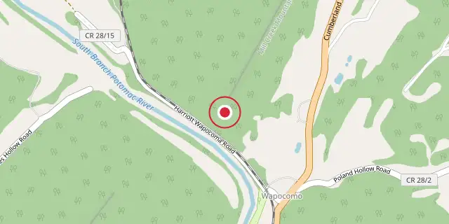
Coordinates: 39°23′56″N 78°44′20″W (39.3990, -78.7390) · Open in OpenStreetMap
Coordinates and connected clubs: the infobox of Wikipedia: Hanging Rocks (CC BY-SA 4.0). Map: drawn by Codexery from OpenStreetMap tiles.
Rising nearly 300 feet above the South Branch Potomac River in Hampshire County, West Virginia, Hanging Rocks are perpendicular cliffs. Located four miles north of Romney at Wappocomo on West Virginia Route 28, they have also been known as Painted Rocks and Blue's Rocks. When distinguished from the Lower Hanging Rocks at Blues Beach to the north, this site is referred to as Upper Hanging Rocks.
History
Hanging Rocks was originally the site of a Native American village, most likely either Lenape or Seneca, and served as the scene of a fierce battle between the Lenape and Catawba. A large party of Lenape had invaded Catawba territory, taken prisoners, and retreated homeward, halting at Hanging Rocks to fish in the South Branch. The pursuing Catawba discovered them and sent parties to their rear and front, enclosing them.
A bloody battle ensued resulting in the deaths of hundreds of Lenape, with very few believed to have escaped. At the time Samuel Kercheval's A History of the Valley of Virginia was written in 1833, a row of Indian graves, possibly belonging to casualties of the battle, existed between the public road and the cliffs. These graves may have been reinterments of bones unearthed during construction of the Baltimore and Ohio Railroad line along the base of Hanging Rocks in the 1880s. Skeletons of 'gigantic size' were exhumed from a purported village and burial site on the farm of Mr. Herriott opposite the South Branch and below Hanging Rocks, along with numerous fireplaces, iron hatchets, glass beads, and brass ornaments.
Persons well-versed in regional history assert that the Native American peoples occupying this village were a branch of the Seneca. There were formerly many stone mounds along the foot of the hill to the rear of this village, varying in height from two to eight feet and in diameter from 12 or 15 to 40 or 50 feet, composed entirely of stone. Fragmentary bones were found in many of the mounds, and one contained a pipe with a wolf's head carved on it.
Geology
Hanging Rocks is arranged as three anticlinal arches, with the most eastern spanning 250 yards, the second 550 yards, and the third 220 yards in width. The formation consists of anticlinal stratified sandstone and limestone layers, with the upper stratum being Monterey and Oriskany sandstone. Below this lies a layer of cherty limestone known as Lewiston chert-lentil, composed of a conglomeration of brachiopods. Atop the cliffs is a level bench of land devoid of stone and containing fine rich soil.
At the western end of the formation is an exposure of fine black to drab shales containing small concretions and fossils, including specimens of Phacops cristata Hall. A volume of The Journal of Geology published in 1915 noted additional species collected in the shale layers, such as Stropheodonta sp., Chonetes cf. lepidus Hall, Dalmanella lenticularis (Vanuxem), Cyrtina hamiltonensis (?) Hall, Ambocoelia umbonata (Conrad), and Styliolina fissurella (Hall). The journal concluded that the Romney shales at Hanging Rocks and Mechanicsburg Gap represent the southwestern continuation of the Onondaga limestone, Marcellus shale, and Hamilton formation of New York. The formation lies within a deep and narrow gap in Mill Creek Mountain formed by the South Branch Potomac River, which flowed in its present course as the mountain formed and slowly cut away at it to expose the rocks.
Did You Know?
- During the French and Indian War, two frontier stockades were built near Hanging Rocks: Fort Williams in 1754 two miles north and Fort Foreman one mile south.
- On June 19, 1861, Captain John Q. Winfield wrote a letter from his encampment at Hanging Rocks, illustrating its proximity to wealthy plantations like Ridgedale and Wappocomo.
More in Wars Involving the Indigenous Peoples of North America
Sources
Compiled from Wikipedia and the sources listed below. Text from Wikipedia is available under CC BY-SA 4.0; this entry is adapted from it.
- Wikipedia: Hanging Rocks (CC BY-SA 4.0).
- Word definitions: the , each quoted from its Wikipedia article.
Spotted an error? Know more?
Reader corrections go straight into our review queue. Suggest an edit · How this site is sourced