
Where Cushioned star has been recorded
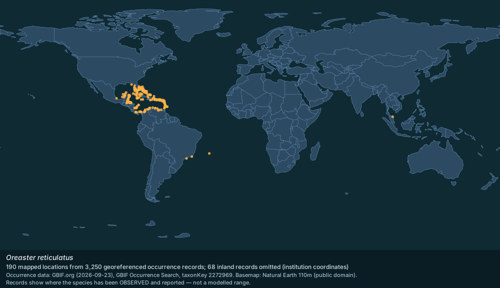
GBIF occurrence records for Oreaster reticulatus, mapped and tabulated by country.

Distribution map plotted from GBIF.org occurrence records; basemap Natural Earth 110m · GBIF records CC0 / CC BY; Natural Earth public domain
3,250 georeferenced occurrence records with coordinates are published for Oreaster reticulatus through GBIF, from 39 countries or marine areas. This page maps those records and lists where they come from. Occurrence records reflect where people have looked as well as where the species lives, so well-surveyed coastlines are over-represented.
- Georeferenced records
- 3,250
- Countries / areas
- 39
- Mapped locations
- 190
- Records sampled for the map
- 3,000
- Inland records omitted
- 68
- Gbif taxonkey
- 2272969
Countries and areas with the most records (GBIF)
United States of America — 539 records; Mexico — 436 records; Panama — 327 records; Bahamas — 226 records; Cayman Islands — 217 records; Belize — 138 records; Cuba — 136 records; Martinique — 134 records; Honduras — 116 records; Colombia — 111 records; Guadeloupe — 111 records; Brazil — 108 records; Dominican Republic — 107 records; Puerto Rico — 104 records; Jamaica — 89 records.
Source: GBIF Occurrence Search (taxonKey 2272969) — https://www.gbif.org/occurrence/search?taxon_key=2272969&has_coordinate=true (records CC0 / CC BY). Accessed 2026-09-23.
Marine regions with a WoRMS distribution record
Cape Hatteras; Florida; Guyanas; Bahamas Exclusive Economic Zone; Caribbean Sea; Gulf of Mexico; Yucatan; Cape Frio; Venezuelan Exclusive Economic Zone; Honduras; Dominican Republic Exclusive Economic Zone; Cuban Exclusive Economic Zone; Nicaraguan part of the Caribbean Sea; Puerto Rican Exclusive Economic Zone; Guatemala; Colombian part of the Caribbean Sea; Costa Rican part of the Caribbean Sea; Haitian Exclusive Economic Zone; Belizean Exclusive Economic Zone; Panamanian part of the Caribbean Sea; Mexico; Bermudian Exclusive Economic Zone; Roncador Bank; Serrana Bank; Mexican Exclusive Economic Zone [Caribbean part]; Isla de Providencia; San Andres; Guatemalan part of the Caribbean Sea; Venezuelan part of the Caribbean Sea; Honduran part of the Caribbean Sea.
Source: WoRMS distribution records (MarineRegions) — https://www.marinespecies.org/aphia.php?p=taxdetails&id=178210 (CC BY 4.0). Accessed 2026-09-23.
How to read this map
The map plots a sample of 3,000 of the 3,250 records, deduplicated to a half-degree grid, so dense areas do not merge into one blob. The sample covers 37 of the 39 countries or areas with records; the areas absent from the sample hold 4 records in total (Bermuda, Chile).
68 records plotting inland were omitted: for a marine species those are almost always the holding institution's coordinates rather than a collection site.
Records show where the species has been observed and reported, not a modelled range.
Source: GBIF Occurrence Search (taxonKey 2272969) — https://www.gbif.org/occurrence/search?taxon_key=2272969&has_coordinate=true (records CC0 / CC BY); WoRMS distribution records (MarineRegions) — https://www.marinespecies.org/aphia.php?p=taxdetails&id=178210 (CC BY 4.0); Natural Earth 110m basemap — https://www.naturalearthdata.com/ (public domain). Accessed 2026-09-23.
Gallery
Related in Cushioned star
Links follow this subject's own source article.
Elsewhere in Cushioned star
Spotted an error? Know more?
Reader corrections go straight into our review queue. Suggest an edit · How this site is sourced