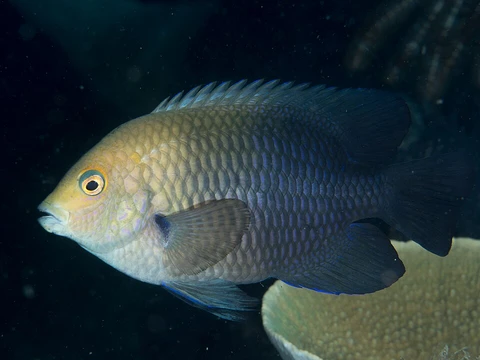
Where Lagoon damselfish has been recorded
GBIF occurrence records for Hemiglyphidodon plagiometopon, mapped and tabulated by country.

1,008 georeferenced occurrence records with coordinates are published for Hemiglyphidodon plagiometopon through GBIF, from 15 countries or marine areas. This page maps those records and lists where they come from. Occurrence records reflect where people have looked as well as where the species lives, so well-surveyed coastlines are over-represented.
- Georeferenced records
- 1,008
- Countries / areas
- 15
- Mapped locations
- 130
- Records sampled for the map
- 1,008
- Inland records omitted
- 24
- Gbif taxonkey
- 2398183
Sovereignty and the Long Dispute
Clipperton Island's history is defined by competing national ambitions over a remote speck of coral in the eastern Pacific. French merchant-explorers first documented the atoll in 1711, and by 1858 it was formally incorporated into the French protectorate of Tahiti. Yet American guano miners began extracting resources there in the early 1890s, and Mexico, pointing to Spanish records dating to the 1520s, staked its own claim. In 1905 Mexico planted a small military colony on the island. The Mexican Revolution severed regular contact with the mainland, and most colonists perished. Lighthouse keeper Victoriano Álvarez seized power and ruled with brutality until eleven survivors were finally rescued in 1917, after which the island was abandoned. The sovereignty question was submitted to binding international arbitration in 1909, with King Victor Emmanuel III of Italy serving as arbitrator. His 1931 ruling confirmed French ownership. Even so, the United States Navy established a weather station on Clipperton in 1944 to support Pacific war operations, prompting French protests before the site was vacated in late 1945.
A Near-Atoll on the East Pacific Rise
Geologically, Clipperton occupies a singular position. Situated at 10°18′N 109°13′W, it is the only emerged feature of the East Pacific Rise and the sole expression of the Clipperton fracture zone that breaks the ocean surface. Unlike most Pacific islands, it lacks an underwater archipelagic apron. The atoll spans 8.9 square kilometres, with a land ring of 1.7 square kilometres averaging just two metres in elevation. On its southeast side, a small volcanic outcropping called Clipperton Rock rises to 29 metres, the remnant of an extinct volcano's rim. Because of this rocky element, the island is technically not a true atoll but a near-atoll. Vegetation is sparse: scattered grasses and a few clumps of coconut palms dot the otherwise barren landscape. The surrounding 3.7-square-kilometre reef teems with corals and is partly exposed at low tide. Despite its proximity to North America—roughly 1,080 kilometres southwest of Mexico—Clipperton is often grouped with Oceania because it falls under French Indo-Pacific administration and its marine fauna resemble those of Hawaii and the Line Islands.
The Enigmatic Freshwater Lagoon
At the heart of Clipperton lies a ring-enclosed lagoon of remarkable peculiarity. Measuring 12 kilometres in circumference and covering 720 hectares, it is the only coral-island lagoon in the eastern Pacific. The water is stagnant and nearly fresh at the surface, yet highly eutrophic, with seaweed beds blanketing roughly 45 percent of the lagoon floor. Strikingly, the lagoon contains no fish. While much of the basin is shallow, several deep pockets plunge to 43–72 metres, including a site called Trou Sans Fond, where the water at the bottom is acidic. The enclosing rim averages 150 metres in width but stretches to 400 metres on the western side and narrows to just 45 metres in the northeast, where waves occasionally spill over into the lagoon. Ten small islets dot the water; six support vegetation, among them the so-called Egg Islands. The lagoon's closure and unique chemistry make it a subject of ongoing scientific curiosity.
A Laboratory in the Open Pacific
Since the mid-twentieth century, Clipperton has served as a natural laboratory for researchers from multiple nations. The SURPACLIP expedition in 1997, a collaboration between Mexico's National Autonomous University and the University of New Caledonia, produced extensive baseline studies. French geographer Christian Jost of the CNRS followed with the Passion 2001 expedition, tracking ecosystem evolution. In 2003, cinematographer Lance Milbrand spent 41 days on the island, producing a GPS map for the National Geographic Society. A four-month mission led by Jean-Louis Étienne in 2005 catalogued the island's mineral, plant, and animal species, surveyed algae to depths of 100 metres, and assessed pollution impacts. In 2008, the University of Washington's School of Oceanography extracted sediment cores from the lagoon to reconstruct a millennium of climate change. The island also hosts significant masked and brown booby colonies, climate-monitoring scientists, and amateur radio DX-peditions. A geodetic marker installed in 2001 continues to track whether the land is rising or sinking.
Related in Lagoon damselfish
Links follow this subject's own source article.
Elsewhere in Lagoon damselfish
Spotted an error? Know more?
Reader corrections go straight into our review queue. Suggest an edit · How this site is sourced