
Nero porostome (Dendrodoris krebsii)
Source-cited species reference: taxonomy from WoRMS, biology from SeaLifeBase, occurrence map from GBIF.
Nero porostome (Dendrodoris krebsii) is a marine species in the family Dendrodorididae (Mollusca › Gastropoda › Nudibranchia), recorded in the World Register of Marine Species as Dendrodoris krebsii (Mörch, 1863) under AphiaID 420607.
- Scientific name
- Dendrodoris krebsii
- Authority
- (Mörch, 1863)
- Family
- Dendrodorididae
- Order
- Nudibranchia
- Maximum length
- 3 cm
- Depth range
- 0–25 m
- Habitat zone
- benthic
- Gbif occurrence records
- 384
Classification (WoRMS)
Full classification as recorded by WoRMS: Kingdom: Animalia · Phylum: Mollusca · Class: Gastropoda · Order: Nudibranchia · Family: Dendrodorididae · Genus: Dendrodoris.
Accepted name: Dendrodoris krebsii · Authority: (Mörch, 1863) · Taxonomic status: accepted · AphiaID: 420607.
Synonyms and superseded combinations recorded for this taxon: Doriopsis krebsii Mörch, 1863; Doris krebsii Mörch, 1863.
Source: World Register of Marine Species (WoRMS) — https://www.marinespecies.org/aphia.php?p=taxdetails&id=420607 (CC BY 4.0). Accessed 2026-09-23.
Biology and life history (SeaLifeBase)
Measured values published by SeaLifeBase for Dendrodoris krebsii. Only fields the database actually holds for this species are shown; these are database values, not aquarium guidance.
Maximum length: 3 cm · Depth range: 0–25 m · Habitat zone: benthic · Vulnerability index: 10 of 100.
SeaLifeBase notes: Assumed maximum length from Ref. 822. Mimicked by the polyclad flatworm Pseudobiceros bajae (Ref. 822).
Source: SeaLifeBase species summary (SpecCode 8527) — https://www.sealifebase.se/summary/Dendrodoris-krebsii.html (CC BY-NC 3.0 — non-commercial use only). Accessed 2026-09-23.
Distribution and occurrence records (GBIF)
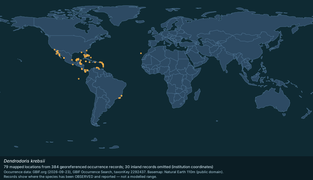
384 georeferenced occurrence records for Dendrodoris krebsii are published through GBIF from 27 countries or marine areas. The map above plots 79 distinct locations from a sample of 384 records, omitting 30 inland records that carry an institution's coordinates rather than a collection site; it shows where the species has been observed and reported, not a modelled range.
Most records by country or area: Mexico (123); Guadeloupe (69); Brazil (46); United States of America (36); Panama (26); Bahamas (15); Saint Martin (French part) (12); Bonaire, Sint Eustatius and Saba (8); Costa Rica (8); Belize (4); Dominican Republic (4); Martinique (4); Saint Barthélemy (3); Colombia (3); Cuba (3).
Marine regions with a valid WoRMS distribution record: Gulf of Mexico; Cuban Exclusive Economic Zone; Costa Rican part of the Caribbean Sea; Colombian part of the Caribbean Sea; Lesser Antilles; Cayman Islands Exclusive Economic Zone; Panamanian part of the Caribbean Sea; Aruban Exclusive Economic Zone; Bonaire Exclusive Economic Zone; Curaçaoan Exclusive Economic Zone; Jamaican Exclusive Economic Zone; Caribbean Sea.
Source: GBIF Occurrence Search (taxonKey 2292437) — https://www.gbif.org/occurrence/search?taxon_key=2292437&has_coordinate=true (records CC0 / CC BY); WoRMS distribution records (MarineRegions) — https://www.marinespecies.org/aphia.php?p=taxdetails&id=420607 (CC BY 4.0); Natural Earth 110m basemap — https://www.naturalearthdata.com/ (public domain). Accessed 2026-09-23.
Gallery
Spotted an error? Know more?
Reader corrections go straight into our review queue. Suggest an edit · How this site is sourced