Aegires ortizi
Source-cited species reference: taxonomy from WoRMS, biology from SeaLifeBase, occurrence map from GBIF.
Last updated

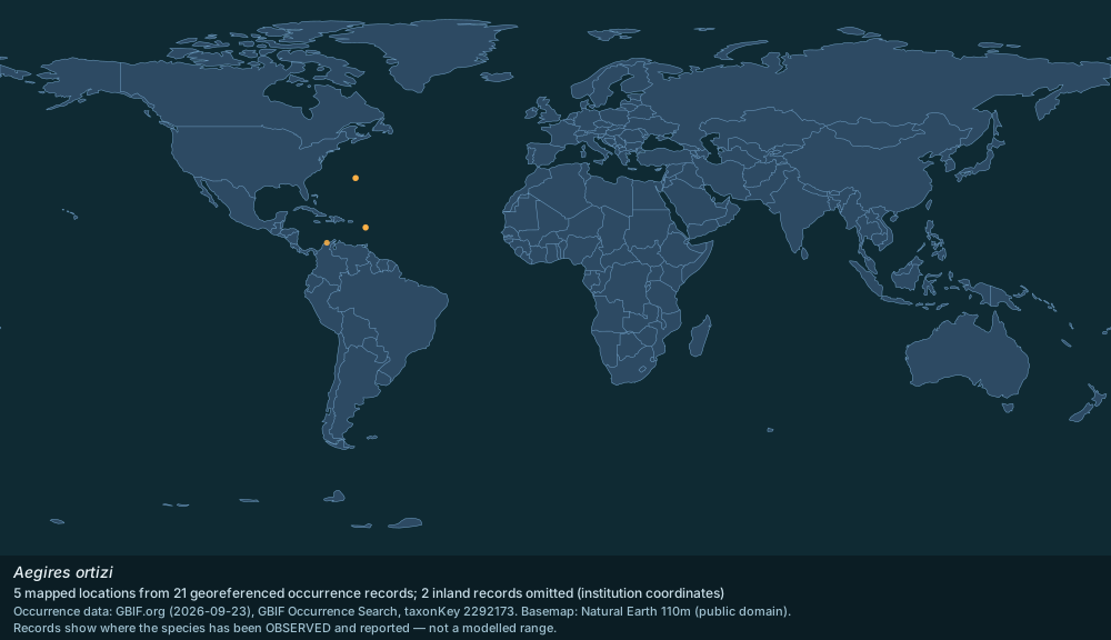
Distribution map plotted from GBIF.org occurrence records; basemap Natural Earth 110m · GBIF records CC0 / CC BY; Natural Earth public domain
Aegires ortizi is a marine species in the family Aegiridae (Mollusca › Gastropoda › Nudibranchia), recorded in the World Register of Marine Species as Aegires ortizi Templado, Luque & Ortea, 1987 under AphiaID 531080.
Scientific classification
- KingdomAnimalia
- PhylumMollusca
- ClassGastropoda
- OrderNudibranchia
- FamilyAegiridae
- GenusAegires
- SpeciesAegires ortizi
Named by Templado, Luque & Ortea, 1987
Close relatives
Other species of Aegires with a Codexery entry.
- Aegires albopunctatus Aegires albopunctatus
Sources: Wikipedia taxobox: Aegires ortizi (CC BY-SA 4.0) · order, family and genus agree with WoRMS AphiaID 531080 (CC BY 4.0)
Where the aegires ortizi has been recorded
Each dot is a place where the species has been observed and reported (21 records, half-degree grid) — not a modelled range. 2 inland records left out (institution coordinates).
Map: drawn by Codexery. Data: GBIF occurrence search (records CC0 / CC BY) · Natural Earth basemap (public domain)
Classification (WoRMS)
Full classification as recorded by WoRMS: Kingdom: Animalia · Phylum: Mollusca · Class: Gastropoda · Order: Nudibranchia · Family: Aegiridae · Genus: Aegires.
Accepted name: Aegires ortizi · Authority: Templado, Luque & Ortea, 1987 · Taxonomic status: accepted · AphiaID: 531080.
Source: World Register of Marine Species (WoRMS) — https://www.marinespecies.org/aphia.php?p=taxdetails&id=531080 (CC BY 4.0). Accessed 2026-09-25.
Biology and life history (SeaLifeBase)
Measured values published by SeaLifeBase for Aegires ortizi. Only fields the database actually holds for this species are shown; these are database values, not aquarium guidance.
Maximum length: 0.8 cm · Depth range: 2–5 m · Habitat zone: demersal · Vulnerability index: 10 of 100 · Aquarium trade: never/rarely.
SeaLifeBase notes: Maximum length is based on maximum reported size in Ref. 083435.
Source: SeaLifeBase species summary (SpecCode 141856) — https://www.sealifebase.se/summary/Aegires-ortizi.html (CC BY-NC 3.0 — non-commercial use only). Accessed 2026-09-25.
Distribution and occurrence records (GBIF)
21 georeferenced occurrence records for Aegires ortizi are published through GBIF from 4 countries or marine areas. The map above plots 5 distinct locations from a sample of 21 records, omitting 2 inland records that carry an institution's coordinates rather than a collection site; it shows where the species has been observed and reported, not a modelled range.
Most records by country or area: Bahamas (11); Bermuda (5); Guadeloupe (4); Colombia (1).
Source: GBIF Occurrence Search (taxonKey 2292173) — https://www.gbif.org/occurrence/search?taxon_key=2292173&has_coordinate=true (records CC0 / CC BY); WoRMS distribution records (MarineRegions) — https://www.marinespecies.org/aphia.php?p=taxdetails&id=531080 (CC BY 4.0); Natural Earth 110m basemap — https://www.naturalearthdata.com/ (public domain). Accessed 2026-09-25.
Sources
Compiled from Wikipedia and the sources listed below. Text from Wikipedia is available under CC BY-SA 4.0; this entry is adapted from it.
- Wikipedia: Aegires ortizi (CC BY-SA 4.0).
- Classification: the source article's taxobox; order, family and genus checked against WoRMS, the World Register of Marine Species (CC BY 4.0).
- Occurrence records: GBIF (CC0 / CC BY). Basemap: Natural Earth (public domain).
- Biology values: SeaLifeBase species summary (CC BY-NC 3.0, non-commercial).
- Word definitions: the , each quoted from its Wikipedia article.
Spotted an error? Know more?
Reader corrections go straight into our review queue. Suggest an edit · How this site is sourced