Spatial analysis
Formal techniques studying entities through spatial properties.
Last updated
Spatial analysis refers to formal techniques that study entities using their topological, geometric, or geographic properties. It is primarily used in urban design and includes a variety of approaches, especially spatial statistics. The field has applications in astronomy, chip fabrication engineering, genomics, and most notably in geospatial analysis of geographic data.
Quick Facts
- Field
- Spatial analysis
- cartography
- surveying
- spatial statistics
- Applications
- Urban design
- astronomy
- chip fabrication
- epidemiology
- ecology
- economics
- remote sensing
- computer science
Facts from the source article.
Lore & Background
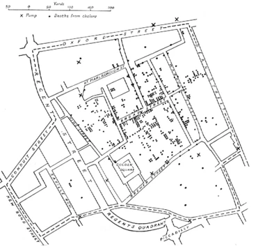
Spatial analysis began with early cartography and surveying. Land surveying dates back to at least 1,400 B.C. in Egypt, where taxable land plots were measured with ropes and plumb bobs. Many fields contributed to its modern form: biology through botanical studies and ethology; epidemiology through disease mapping, notably John Snow's cholera outbreak map; statistics through spatial statistics; economics through spatial econometrics; geographic information systems through software; remote sensing through morphometric and clustering analysis; computer science through algorithms and computational geometry; and mathematics through fractals and scale invariance.
Reader's Guide
Spatial analysis confronts fundamental issues in defining objects of study, constructing analytic operations, using computers, and presenting results. Common errors arise from the mathematics of space, data presentation, and available tools. Census data aggregated into local units raises statistical issues. The fractal nature of coastlines makes precise length measurement difficult; computer software fitting straight lines to a coastline may produce lengths with no inherent meaning.
These problems are challenging because maps combine generally accurate spatial data with potentially inaccurate analytic results, creating an impression of greater accuracy. Spatial dependence—the relationship of variable values or locations across space—is measured through spatial correlation, covariance functions, and semivariograms. Methods like Kriging are used for spatial interpolation.
Spatial dependency leads to autocorrelation problems in statistics, violating assumptions of independence. Regression analyses that do not compensate can yield unstable estimates. Spatial heterogeneity means overall parameters may not describe processes at any given location. Spatial association is the degree to which things are similarly arranged in space, analyzed through map overlay and regression.
Frequently Asked Questions
What is Spatial analysis?
Spatial analysis is a set of formal methods that examine objects or phenomena through their topological, geometric, or geographic characteristics. It draws on cartography, surveying, and spatial statistics, and functions as a core analytical discipline within the broader GIS framework.
What is Spatial analysis most known for?
The field is recognized for rigorous techniques that study entities via their spatial properties, especially spatial statistics and geometric operations. It also tackles foundational challenges such as the boundary problem and the modifiable areal unit problem, which shape how researchers define and aggregate spatial data.
Where does Spatial analysis show up outside of mapping?
Beyond its flagship role in geospatial analysis of geographic data, the techniques are applied in urban design, astronomy, chip fabrication engineering, epidemiology, ecology, economics, remote sensing, and computer science. This cross-disciplinary reach makes it one of the most versatile quantitative tools in modern research.
How does Spatial analysis differ from GIS as a whole?
GIS is the broader platform for capturing, storing, and visualizing geographic data, while spatial analysis is the reasoning layer that applies formal statistical and geometric methods to extract patterns from that data. In short, GIS supplies the toolkit and spatial analysis supplies the analytical logic.
Why is Spatial analysis considered central to the GIS community?
It provides the methodological backbone that converts raw geographic data into explanatory insight, whether that means modeling disease spread, optimizing city layouts, or detecting patterns in genomic sequences. Without its formal frameworks, spatial data would remain largely descriptive rather than predictive.
More in Spatial Analysis & Gis
Sources
Compiled from Wikipedia and the sources listed below. Text from Wikipedia is available under CC BY-SA 4.0; this entry is adapted from it.
- Wikipedia: Spatial analysis (CC BY-SA 4.0).
Spotted an error? Know more?
Reader corrections go straight into our review queue. Suggest an edit · How this site is sourced