Geographic information system
Last updated
The industry and profession dealing with these information systems is most commonly referred to as geographic information systems, also abbreviated GIS, using the uncounted plural form.[1]
Quick Facts
- First digital gis developed
- 1963 (Canada Geographic Information System, CGIS)
- Term coined by
- Roger Tomlinson (mid-1960s)
Facts from the source article.
Key facts and history
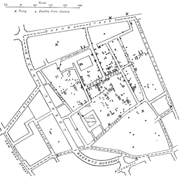
One of the first known instances in which spatial analysis was used came from the field of epidemiology in 1832.[2] Tomlinson first coined the term geographic information system (GIS) and becomes known as the “father of GIS”.[3] He introduces the “layer cake” method of stacking information that becomes fundamental to modern map overlays in GIS.[3] In 1964, Howard T. Fisher formed the Laboratory for Computer Graphics and Spatial Analysis at the Harvard Graduate School of Design.[4]
By the late 1970s, two public domain GIS systems (MOSS and GRASS GIS) were in development.[5] Waldo Tobler authored the initial publication that described using computers to aid cartography in 1959.[6] The federal Department of Forestry and Rural Development created the first truly operational GIS in 1963, located in Ottawa, Ontario, Canada.[7]
What the cited sources add
Esri is a pioneer in GIS since its founding in 1969.[3] Scott Morehouse, who worked in the Harvard Lab on ODYSSEY, moves to ESRI in 1981 and plays a key role in the development of ARC/INFO.[3] When performing heads-up digitizing, geographic data is traced directly onto aerial imagery.[8]
References
- Wikipedia, "Geographic information system" (CC BY-SA 4.0), which cites: Goodchild, "Twenty years of progress: GIScience in 2010", Journal of Spatial Information Science, 2010 (original not read by us) en.wikipedia.org
- Wikipedia, "Geographic information system" (CC BY-SA 4.0), which cites: "Rapport sur la marche et les effets du choléra dans Paris et le département de la Seine. Année 1832", Gallica (original not read by us) en.wikipedia.org
- "History of GIS Early History and the Future of GIS – Esri", esri.com. esri.com
- Wikipedia, "Geographic information system" (CC BY-SA 4.0), which cites: Lovison-Golob, "Howard T. Fisher", Harvard University (original not read by us) en.wikipedia.org
- Wikipedia, "Geographic information system" (CC BY-SA 4.0), which cites: "Open Source GIS History – OSGeo Wiki Editors" (original not read by us) en.wikipedia.org
- Wikipedia, "Geographic information system" (CC BY-SA 4.0), which cites: Tobler, "Automation and Cartography", Geographical Review, 1959, p. 526–534; Fitzgerald, "Map Printing Methods" (original not read by us) en.wikipedia.org
- Wikipedia, "Geographic information system" (CC BY-SA 4.0), which cites: "History of GIS Early History and the Future of GIS – Esri", esri.com; "Roger Tomlinson", UCGIS, 21 February 2014 (we also read that source) en.wikipedia.org
- Wikipedia, "Geographic information system" (CC BY-SA 4.0), which cites: Puotinen, "A Primer of GIS: Fundamental Geographic and Cartographic Concepts – By Francis Harvey", Geographical Research, June 2009, p. 219–221; "Digitizing - GIS Wiki The GIS Encyclopedia", wiki.gis.com (we also read that source) en.wikipedia.org
Each numbered sentence above was checked against the source it cites before publication. Sentences citing Wikipedia adapt text from the English Wikipedia article Geographic information system (contributors), used under CC BY-SA 4.0; this entry is available under the same licence. Other sources were used for facts only.
More in Spatial Analysis & Gis
Sources
Compiled from Wikipedia and the sources listed below. Text from Wikipedia is available under CC BY-SA 4.0; this entry is adapted from it.
- Wikipedia: Geographic information system (CC BY-SA 4.0).
Spotted an error? Know more?
Reader corrections go straight into our review queue. Suggest an edit · How this site is sourced