Trzy Korony
The Three Crowns: a limestone summit with a panoramic observation deck over the Dunajec River Gorge.
Last updated
Where it is
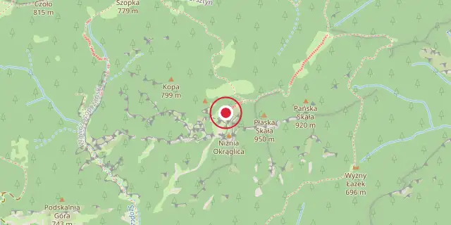
Coordinates: 49°24′50″N 20°24′50″E (49.4140, 20.4140) · Open in OpenStreetMap
Coordinates and connected clubs: the infobox of Wikipedia: Trzy Korony (CC BY-SA 4.0). Map: drawn by Codexery from OpenStreetMap tiles.
Trzy Korony is the highest point of the Three Crowns Massif, a separate section of the Pieniny Mountains in southern Poland. It sits at the heart of a tight cluster of linked peaks called Pieniny Środkowe, which are built mostly from limestone and dolomite. This summit lies inside the Pieniny National Park, in the Lesser Poland Voivodeship.
The summit is cut off from the neighboring Łysiny Group by the Wyżni Łazek Pass, with deep, forested valleys and streams dropping away on either side. Five sharp limestone peaks make up the Three Crowns. The tallest, Okrąglica, reaches 982 meters above sea level. On top of Okrąglica, an observation platform with metal railings was built for visitors; it overlooks the Dunajec River Gorge and can hold up to fifteen people at once.
Southeast of Okrąglica, Płaska Skała rises to 950 meters, making it the second highest. Southwest of Okrąglica, Nad Ogródki stands 940 meters tall and once had a weather station, built in 1933, that was run manually by a hermit. The fourth peak, Pańska or Bryłowa Skała, reaches 920 meters and is a nesting site for the rare wallcreeper, a bird with striking crimson wings. The smallest peak, Niżnia Okrąglica (also called Ganek or Siodło), lies to the south and is 80 meters lower than the tallest; it held the original observation deck before the metal platform was added to Okrąglica, expanding the view of the Pieniny panorama.
Trzy Korony is one of the most popular tourist spots in the Pieniny range. The observation deck juts out over a 500-meter drop, offering views of the Dunajec River Gorge, the Pieniny National Park, the Tatra Mountains, Beskid Sądecki, the Gorce Mountains, and Beskid Żywiecki. On clear days, Babia Góra, 63 kilometers away, is visible.
Originally, the massif was simply called Pieniny. In 1834, under Austrian-Hungarian rule, the German name Kronenberg appeared in records, which translates to "the Crown" in Polish.
The current name, Trzy Korony, became common around 1860. The massif hosts at least seven species of rare plants found nowhere else in the Pieniny, including the now-extinct Pieniny dandelion and Złocień Zawadzkiego. It also supports numerous lime-loving rock plants, such as Rozchodnik wielki, which serves as a host for the caterpillar of the rare Pieniny Apollo butterfly.
Tourism to the Three Crowns has a long history. The first recorded climb to the top happened in 1767, and regular tourists began arriving around 1830.
In 1906, the first official trail from Krościenko was marked with blue signs. After Poland regained independence, the Polish government bought the Three Crowns from private owners in 1929, and the Pieniny National Park was established in 1932. Between 2001 and 2002, park authorities built the new metal platforms and barriers to handle the growing number of visitors.
Tourist trails
All marked trails to the summit start from the main roads below and meet at the peak called Siodło. From there, it takes about fifteen minutes to reach the viewing platform on the tallest peak.
During tourist season, access to the platform requires a fee, which also allows entry to the peak of Sokolica. In good weather, long queues often form at the entrance. At the southern foot of the Three Crowns, in the village of Sromowce Niżne, a popular hostel run by PTTK is called the Three Crowns.
Several color-coded trails lead to the summit from nearby towns. The blue trail from Szczawnica goes through Sokolica, Czertezik, Czerteż, Bajków Groń (Sokola Perć), and Zamkowa Góra. The yellow trail from Szczawnica passes Polana Wyrobek and Przełęcz Szopka before joining the blue trail. From Krościenko nad Dunajcem, yellow and blue trails go via Przełęcz Szopka and then follow the blue trail to Siodło; the trip takes about two hours up and one hour forty-five minutes down.
Another yellow and blue route from Krościenko goes through Zamkowa Góra. From Sromowce Niżne, yellow and blue trails lead through Wąwóz Szopczański, along Przełęcz Szopka, and then join the blue trail to Siodło. Alternatively, yellow, green, and blue trails from Sromowce Niżne go through Wąwóz Szopczański, then follow the green trail to Wyżni Łazek and the clearing Kosarzyska, and from there the blue trail to Siodło; this also takes about two hours up and one hour forty-five minutes down.
The blue trail from Czorsztyn passes through Przełęcz Osice, Macelak, Przełęcz Trzy Kopce, and Przełęcz Szopka toward Siodło. From Sromowce Wyżne, red and blue trails from the rafting station on the Dunajec in Kąty village lead to Przełęcz Trzy Kopce (about forty-five minutes), where they meet the blue trail coming up from Czorsztyn.
More in National parks of Poland
Sources
Compiled from Wikipedia and the sources listed below. Text from Wikipedia is available under CC BY-SA 4.0; this entry is adapted from it.
- Wikipedia: Trzy Korony (CC BY-SA 4.0).
Spotted an error? Know more?
Reader corrections go straight into our review queue. Suggest an edit · How this site is sourced