
Federated States of Micronesia
Sovereign island federation in free association with the United States.

U.S. Navy photo by Petty Officer 1st Class William Spears · Public domain
The Federated States of Micronesia (FSM) is an island country located in the Micronesian region of Oceania. This federation comprises the majority of the Caroline Islands, excluding Palau, and is made up of four states: Yap, Chuuk, Pohnpei, and Kosrae. Spanning the western Pacific just north of the equator, the nation includes around 607 islands with a combined land area that is relatively small. However, its waters occupy a vast expanse of the Pacific Ocean, granting it the fourteenth-largest exclusive economic zone globally. The capital is Palikir on Pohnpei Island, while the largest city is Weno, a municipality in the Chuuk Lagoon. Each state is centered on one or more main volcanic islands, and all except Kosrae include numerous outlying atolls.
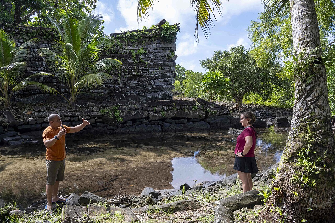
The ancestors of the Micronesians settled over four thousand years ago, developing a decentralized chieftain system that eventually centralized around Yap Island. On Pohnpei, the site of Nan Madol—a UNESCO World Heritage Site of artificial islands linked by canals—served as the ceremonial and political seat of the Saudeleur dynasty from about AD 500 until its collapse around 1500. European contact began in the sixteenth century with Portuguese and Spanish explorers. The Spanish incorporated the archipelago into the Spanish East Indies, later establishing a settlement on Pohnpei. Following the Spanish–American War, Spain sold the islands to Germany in 1899. Japan captured the islands during World War I and administered them under a League of Nations mandate. During World War II, Truk Lagoon was a major Japanese base, heavily attacked by the U.S. Navy in Operation Hailstone in 1944. After the war, the islands became part of the United Nations Trust Territory of the Pacific Islands, administered by the United States. On May 10, 1979, four districts ratified a constitution to form the FSM. The nation became a sovereign state on November 3, 1986, under a Compact of Free Association with the United States, with independence formally concluded in 1990 when the UN ended trusteeship.
- Capital
- Palikir, on Pohnpei Island
- Largest city
- Weno, in Chuuk Lagoon
- Exclusive economic zone rank
- 14th largest in the world
Quick Facts
- Languages Type
- Official language
- Languages2 Type
- Recognized regional / languages
- Conventional Long Name
- Federated States of Micronesia
- Common Name
- the Federated States of Micronesia
- Symbol Type
- Seal
- National Motto
- "Peace, Unity, Liberty"
- National Anthem
- "Patriots of Micronesia"
- Capital
- Palikir
- Largest Settlement
- Weno
- Largest Settlement Type
- city
- Languages
- English
- Languages2
- Chuukese · Kosraean · Pohnpeian · Yapese
Facts from the source article.
Lore & Background
The Federated States of Micronesia is an island country in the western Pacific Ocean, situated just north of the equator. Its territory encompasses the majority of the Caroline Islands, excluding Palau, and stretches from west to east across four states: Yap, Chuuk, Pohnpei, and Kosrae. The federation comprises around 607 islands, with a combined land area that is relatively small, though its surrounding waters occupy a vast expanse of the Pacific, granting it the 14th-largest exclusive economic zone in the world. Each state is centered on one or more main volcanic islands, and all except Kosrae include numerous outlying atolls. The nation’s capital is Palikir on Pohnpei Island, while its largest city is Weno, located in the Chuuk Lagoon. The islands lie northeast of Indonesia and Papua New Guinea, south of Guam and the Marianas, west of Nauru and the Marshall Islands, and east of Palau and the Philippines. The ancestors of the Micronesians settled over four thousand years ago, initially developing a decentralized chieftain-based system that later evolved into a more centralized culture centered on Yap. On Pohnpei, the site of Nan Madol—a UNESCO World Heritage Site consisting of small artificial islands linked by canals—served as the ceremonial and political seat of the Saudeleur dynasty, which united the island’s population from about AD 500 until its collapse around 1500. European contact began in the sixteenth century with Portuguese and Spanish explorers, and Spain later incorporated the archipelago into the Spanish East Indies, establishing outposts and missions. After the Spanish–American War, Germany purchased the islands in 1899 and incorporated them into German New Guinea. Japan captured the islands during World War I and administered them under a League of Nations mandate as part of the South Seas Mandate. During World War II, Chuuk Lagoon served as a major Japanese naval base, and in February 1944, the U.S. Navy launched Operation Hailstone, a massive air and surface attack that severely diminished Japan’s naval capabilities in the Pacific. Following the war, the United Nations placed the islands under U.S. administration as part of the Trust Territory of the Pacific Islands. On May 10, 1979, four of the trust territory’s districts ratified a constitution to become the Federated States of Micronesia, which became a sovereign state on November 3, 1
Reader's Guide
The Federated States of Micronesia represents a unique model of post-colonial sovereignty, emerging from a UN trust territory to become a self-governing nation in free association with the United States. system with a unicameral Congress and an executive chosen from among its members. The nation's strategic location in the western Pacific and its vast exclusive economic zone—the 14th largest in the world—underscore its geopolitical importance, particularly in relation to U.S. defense responsibilities and regional diplomacy. The FSM's history includes early centralized cultures like the Saudeleur dynasty at Nan Madol, European colonial rivalries, Japanese mandate, and World War II devastation at Truk Lagoon. The nation's continued reliance on U.S.
Did You Know?
- The Federated States of Micronesia has the 14th-largest exclusive economic zone in the world, covering nearly 3 million km² of ocean.
- Nan Madol, on Pohnpei, is a UNESCO World Heritage Site consisting of artificial islands linked by canals, often called the 'Venice of the Pacific'.
Gallery
Frequently Asked Questions
How does FSM's relationship with the United States work?
Under the Compact of Free Association, the United States takes responsibility for the federation's defense while FSM retains its own sovereign government. The US also provides periodic financial assistance to the island nation as part of this security arrangement.
Why is FSM's exclusive economic zone so notable?
Although the actual land area is minuscule, the nation's exclusive economic zone ranks as the 14th largest in the world. This enormous ocean footprint gives the tiny federation meaningful leverage in Pacific maritime and geopolitical discussions.
What are the capital and largest city of FSM?
The seat of government is Palikir on Pohnpei Island, while the most populous urban center is Weno, situated on the island of Chuuk inside Chuuk Lagoon. Together they serve as the administrative and demographic anchors of the federation.
More in Islands And Archipelagos 1-24
Spotted an error? Know more?
This is a living reference — every entry is fact-audited, and reader corrections feed straight into our audit queue. Suggest an edit · See this site's audit record