Treaty of Tordesillas

Koppchen · CC BY 3.0
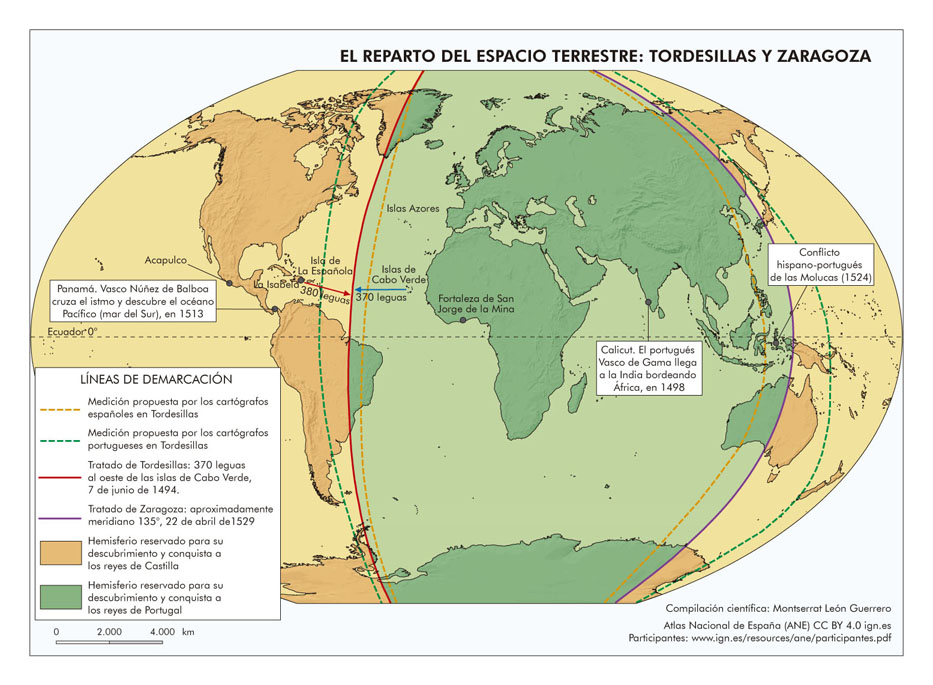
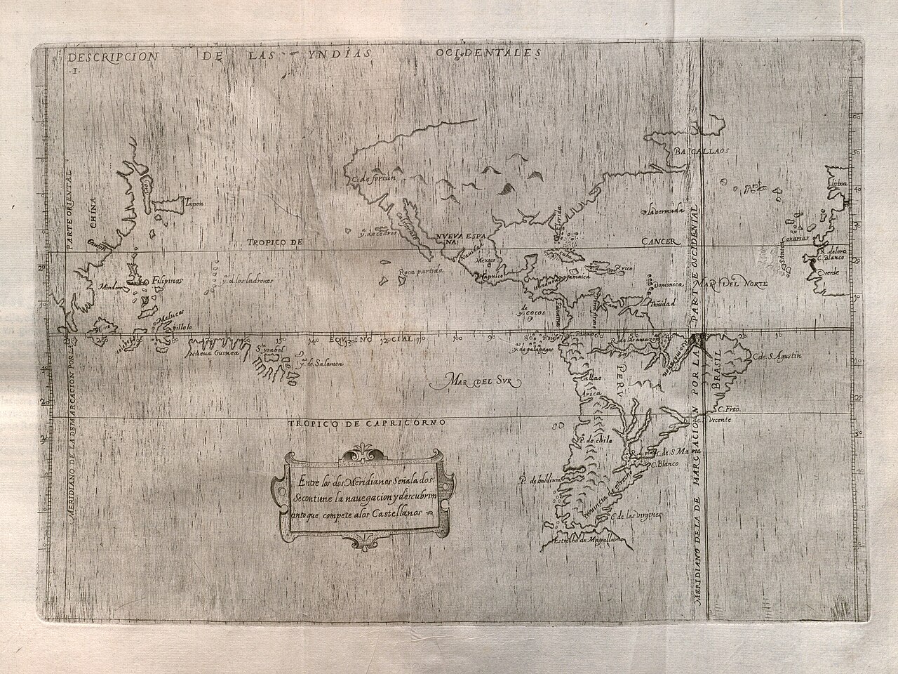
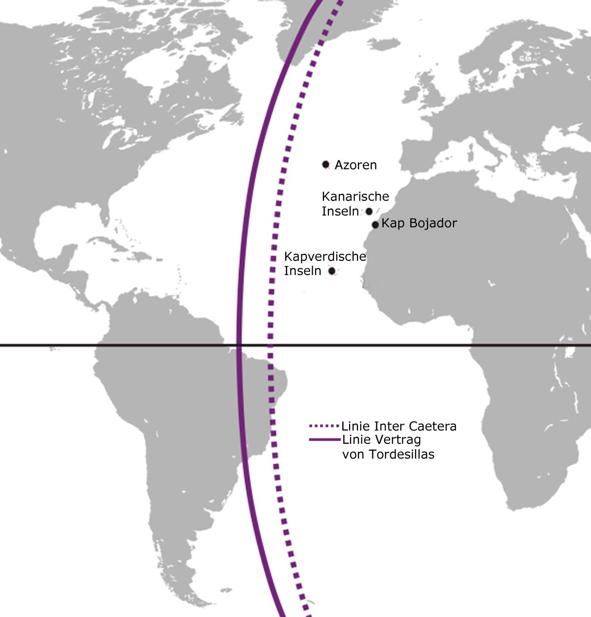
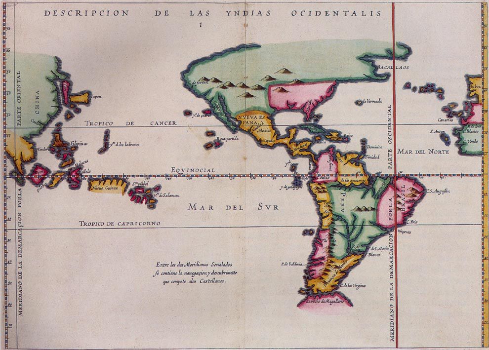
In June 1494, Spain and Portugal signed an agreement in the Spanish town of Tordesillas, later ratified in Portugal’s Setúbal, to split all newly discovered lands beyond Europe between them. The dividing line ran 370 leagues—roughly 2,100 kilometers or 1,300 miles—west of the Cape Verde islands off Africa’s coast. This placed the boundary about midway between Portuguese-held Cape Verde and the islands Christopher Columbus had visited on his first voyage for Castile (which he mistook for Cipangu and Antillia, but were actually Cuba and Hispaniola; the treaty itself never names those mythical places). Everything east of the line went to Portugal, everything west to Castile, revising an earlier papal decree by Pope Alexander VI. The treaty was signed on 7 June 1494, ratified by Spain on 2 July 1494, by Portugal on 5 September 1494, and later by Pope Julius II on 24 January 1506. The opposite side of the globe was divided decades afterward by the Treaty of Zaragoza, signed on 22 April 1529, which set the antimeridian to the Tordesillas line. Spain and Portugal mostly followed the treaties, but the Indigenous peoples of the Americas never recognized them. UNESCO added the Treaty of Tordesillas to its Memory of the World register in 2007. The original copies are kept in Spain’s General Archive of the Indies and Portugal’s Torre do Tombo National Archive.
The treaty aimed to settle a dispute that erupted after Columbus returned to Spain in 1493 from his first voyage under Castile’s flag. On his way back, he stopped in Lisbon and met King John II of Portugal, trying to convince him that islands existed southwest of the Canaries. Upon learning of Columbus’s discoveries, the Portuguese king sent a threatening letter to Spain’s Catholic Monarchs, Ferdinand and Isabella, arguing that the 1479 Treaty of Alcáçovas and the 1481 papal bull *Aeterni regis* gave Portugal all lands south of the Canaries—including Columbus’s finds. He added that he was preparing a fleet under Francisco de Almeida to claim them. The Spanish rulers replied that the islands belonged to Spain and warned Portugal not to send anyone there. They then invited Portuguese ambassadors to negotiate. On 4 May 1493, Pope Alexander VI (a Valencian-born Aragonese) issued the bull *Inter caetera*, declaring that all lands west of a pole-to-pole line 100 leagues west of the Azores or Cape Verde belonged to Castile, except any territory under Christian rule as of Christmas 1492. This bull did not mention Portugal or its lands, so Portugal could not claim newly discovered lands even east of the line. A second bull, *Dudum siquidem*, dated 25 September 1493, gave Spain all mainlands and islands “at one time or even still belonging to India,” even if east of the line. King John II was unhappy, feeling the arrangement gave Portugal too little—especially blocking access to India, his near-term goal. By 1493, Portuguese explorers had reached the Cape of Good Hope. Portugal was unlikely to fight over Columbus’s islands, but the explicit mention of India was a major problem. Since the Pope would not adjust the line, John opened direct talks with Ferdinand and Isabella. He accepted *Inter caetera* as a starting point but pushed the boundary 270 leagues west (the exact length of a league was undefined), protecting Portugal’s route down Africa’s coast and granting them lands that now form eastern Brazil. One scholar later noted that both sides knew such a vague line could not be precisely fixed, and each thought the other was deceived, calling it a diplomatic win for Portugal that secured not only the true route to India but most of the South Atlantic.
The treaty was negotiated without consulting Pope Alexander VI and effectively replaced his bulls, though it was later sanctioned by his successor Pope Julius II in the bull *Ea quae pro bono pacis* on 24 January 1506—hence some call it the “Papal Line of Demarcation.” Very little of the divided area had been seen by Europeans at the time. Castile gained most of the Americas, which in 1494 held little proven wealth. The eastern part of present-day Brazil went to Portugal when Pedro Álvares Cabral landed there in 1500 while sailing to India. Some historians believe the Portuguese already knew about the South American bulge that forms most of Brazil before this, so Cabral’s landing was no accident. One scholar notes that Cabral came ashore 12 degrees farther south than the expected Cape São Roque, making it unlikely that freak weather or a navigational error caused the landfall, and highly probable that he was ordered to investigate a coast whose existence was not merely suspected.
- Location
- Tordesillas, Spain
- Parties
- Kingdom of Portugal and Crown of Castile
Lore & Background
The treaty was intended to solve the dispute that arose following the return in 1493 of Christopher Columbus and his crew, who had sailed under the Crown of Castile, from their first voyage. On his way back to Spain, he first stopped at Lisbon, where he requested another meeting with King John II to prove to him that there were more islands to the southwest of the Canary Islands. After learning of the Castilian-sponsored voyage, the Portuguese king sent a threatening letter to the Catholic Monarchs, King Ferdinand and Queen Isabella, stating that by the Treaty of Alcáçovas signed in 1479 and by the 1481 papal bull Aeterni regis that granted all lands south of the Canary Islands to Portugal, all of the lands discovered by Columbus belonged to Portugal. The Portuguese king also stated that he was already making arrangements for a fleet (an armada led by Francisco de Almeida) to depart shortly and take possession of the new lands. The Spanish rulers replied that Spain owned the islands discovered by Columbus and warned King John II not to permit anyone from Portugal to go there. Finally, the rulers invited Portugal to send ambassadors to begin diplomatic negotiations aimed at settling the rights of each nation in the Atlantic. On 4 May 1493, Pope Alexander VI (Rodrigo Borgia), an Aragonese from Valencia by birth, decreed in the bull Inter caetera that all lands west of a pole-to-pole line 100 leagues west of any of the islands of the Azores or the Cape Verde Islands should belong to Castile, although territory under Christian rule as of Christmas 1492 would remain untouched. The bull did not mention Portugal or its lands, so Portugal could not claim newly discovered lands even if they were east of the line. Another bull, Dudum siquidem, entitled Extension of the Apostolic Grant and Donation of the Indies and dated 25 September 1493, gave all mainlands and islands, "at one time or even still belonging to India" to Spain, even if east of the line. The Portuguese King John II was not pleased with that arrangement, feeling that it gave him far too little land—it prevented him from possessing India, his near-term goal. By 1493, Portuguese explorers had reached the southern tip of Africa, the Cape of Good Hope. The Portuguese were unlikely to go to war over the islands encountered by Columbus, but the explicit mention of India was a major issue. As the Pope had not made changes, the Portuguese king opened direct negotiations with the Catholic Monarchs to move the line to the west and allow him to claim newly discovered lands east of the line. In the bargain, John accepted Inter caetera as the starting point of discussion with Ferdinand and Isabella but had the boundary line moved 270 leagues west ('leagues' being undefined), in order to protect the Portuguese route down the coast of Africa and giving the Portuguese rights to lands that now constitute the eastern quarter of Brazil. As one scholar assessed the results, "both sides must have known that so vague a boundary could not be accurately fixed, and each thought that the other was deceived", concluding that it was a "diplomatic triumph for Portugal, confirming to the Portuguese not only the true route to India, but most of the South Atlantic". The treaty was negotiated without consulting Pope Alexander VI and effectively superseded his bulls. However, it was subsequently sanctioned by his successor Pope Julius II by means of the bull Ea quae pro bono pacis of 24 January 1506 and therefore some sources call the resulting line the "Papal Line of Demarcation".
Reader's Guide
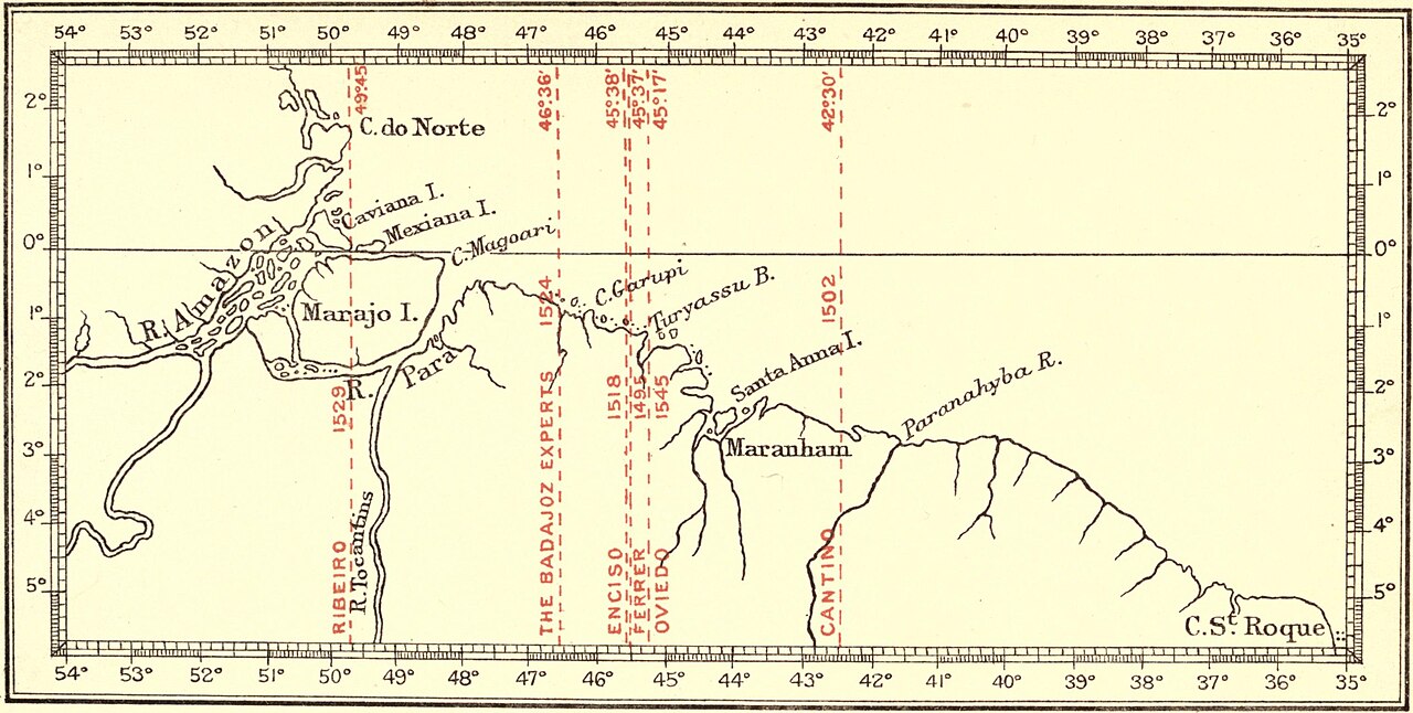
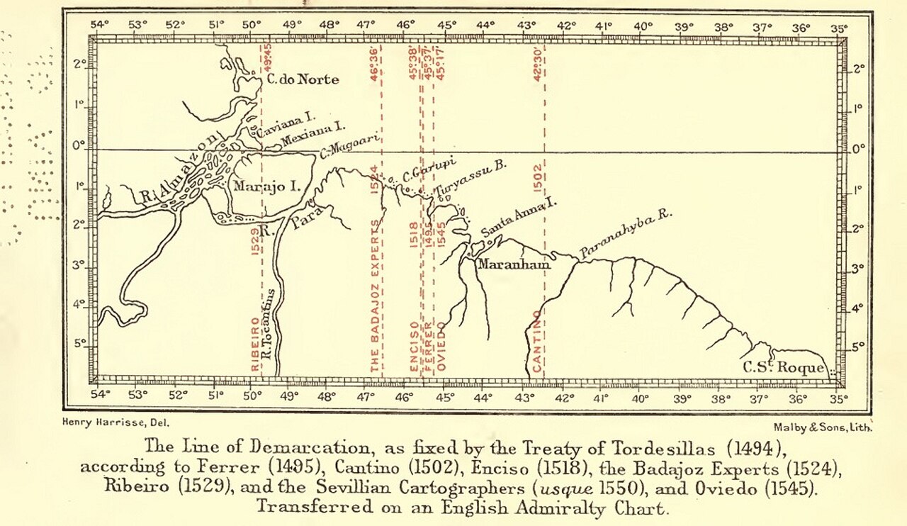
The Treaty of Tordesillas only specified the line of demarcation in leagues from the Cape Verde Islands. It did not specify the length of the league, its equivalent in equatorial degrees, or which of the Cape Verde islands was intended. Instead, the treaty provided that these matters were to be settled by a joint voyage. This voyage never occurred, and instead there were only a series of nonbinding expert opinions produced over the next several decades. Their computations were further complicated by remaining uncertainty about the exact equatorial circumference of the earth. As such, each proposed line can be variously computed using geographical leagues defined in terms of a degree using a ratio which applies regardless of the size of the earth or using a specifically measured league applied to the actual equatorial circumference of the earth, with allowances necessary for the imperfect Portuguese and Spanish knowledge of its true dimensions. The earliest Aragonese opinion was provided by Jaime Ferrer in 1495 at the request of Ferdinand and Isabella. He stated to them that the demarcation line was 18° west of the most central island of the Cape Verde Islands, equivalent to 24°25′ west of Greenwich. (Harrisse concludes Ferrer must have meant Fogo as this central island.) Thus, Ferrer placed the line at 42°25′ W. on his sphere, which was 21.1% larger than the actual size of the earth. Harrisse further concludes from Ferrer's claim that his league contained 32 Olympic stades (6.15264 km or 3.82307 mi) that his line—if perfectly measured—would have corresponded to a position 2,276.5 km (1,414.6 mi) west of Fogo at 47°37′ W. The earliest surviving Portuguese opinion is on the Cantino planisphere of 1501 or 1502, generally considered to represent the Portuguese standard map of its day. Because its demarcation line was midway between Cape Saint Roque, the northeast cape of South America, and the mouth of the Amazon River, labeled the Great River (Rio Grande) with an estuary marked "All of this sea is fresh water" (Todo este mar he de agua doçe), Harrisse computed that this line was at 42°30′ W. on the actual globe. Harrisse believed the large estuary just west of the line on the Cantino map was that of the Rio Maranhão (this estuary is now the Baía de São Marcos and the river is now the Mearim), whose flow is so weak that its gulf does not contain fresh water. In 1518, another Castilian opinion was provided by Martin Fernández de Enciso. Harrisse computes that Enciso's sphere was 7.7% smaller than the actual size of the earth so his line at 47°24′ W. corresponds to the actual 45°38′ W. based on his other numerical data. Enciso further described the coastal features near which the line passed, but in a very confused manner that might place the line as far west as the mouth of the Amazon between 49°W and 50°W. In 1524, the Castilian mathematician Tomás Durán and pilots Sebastian Cabot (son of John Cabot) and Juan...
Did You Know?
- The Treaty of Tordesillas was signed on 7 June 1494 and ratified by Spain on 2 July 1494, by Portugal on 5 September 1494, and by Pope Julius II on 24 January 1506.
- The line of demarcation was 370 leagues (c. 2,100 km or 1,300 mi) west of the Cape Verde islands, but the treaty did not specify the length of the league or which island was intended.
- The treaty was added by UNESCO to its Memory of the World international register in 2007.
- Originals of both treaties are kept at the General Archive of the Indies in Spain and at the Torre do Tombo National Archive in Portugal.
- The other side of the world was divided a few decades later by the Treaty of Zaragoza, signed on 22 April 1529.
Gallery
Frequently Asked Questions
Who signed the Treaty of Tordesillas?
The agreement was concluded between the Kingdom of Portugal and the Crown of Castile, the two Iberian powers competing over newly encountered overseas territories.
What was the Treaty of Tordesillas?
It was a 1494 bilateral accord that drew an imaginary north-south meridian in the Atlantic to split undiscovered lands between the two signatory crowns. The line was meant to settle the territorial rivalry that erupted after Columbus's first voyage westward.
Where was the Treaty of Tordesillas signed?
The document was formalized in the town of Tordesillas, in the Kingdom of Castile (modern-day Spain), giving the treaty its name.
Why was the Treaty of Tordesillas created?
Columbus's 1492 voyage triggered a clash of claims between Portugal and Castile over which crown owned the new lands. The treaty was drafted to resolve that dispute and effectively superseded the earlier papal bull issued by Pope Alexander VI that had attempted a similar division.
What did the Treaty of Tordesillas actually do?
It established a meridian roughly 370 leagues west of the Cape Verde Islands, granting lands east of the line to Portugal and lands west of it to Castile. In practice this gave Portugal a legal foothold on the Brazilian coast while leaving most of the rest of the Americas under Castilian claim.
More in Exploration & Colonization 1-15
Spotted an error? Know more?
This is a living reference — every entry is fact-audited, and reader corrections feed straight into our audit queue. Suggest an edit · See this site's audit record