6th October Bridge
Last updated
Where it is
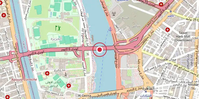
Coordinates: 30°02′56″N 31°13′44″E (30.0490, 31.2290) · Open in OpenStreetMap
Coordinates and connected clubs: the infobox of Wikipedia: 6th October Bridge (CC BY-SA 4.0). Map: drawn by Codexery from OpenStreetMap tiles.
The 6th of October Bridge is an elevated highway in Cairo, Egypt. It crosses the Nile twice, connecting Giza through Gezira Island to Downtown Cairo and onward to highways leading to Cairo International Airport. Its name commemorates the date of Operation Badr in 1973, when Egyptian forces crossed the Suez Canal and attacked the Bar Lev Line.
History
Spanning 21.193 kilometers from Dokki to Nasr City, the 6th October Bridge and causeway took nearly three decades to build. Work started in 1969 with a 130-meter phase over the Nile's west branch, completed in 1972. The final phase finished in 2005. Designated a national infrastructure project, the bridge received an expansion and upgrade order from President Abdel Fattah el-Sisi in April 2021.
Route
The 6th of October starts at an intersection with Ministry of Agriculture Street, travels east, meets the western Corniche, and crosses the Nile. It passes through El Gezira island, crosses the Nile again, and reaches a large intersection at Abdel Minaam Riyadh Square. It continues paralleling Ramses Street and railway and metro tracks, passes near Ghamra and El Demerdash metro stations, intersects Salah Salem road, and merges with the Emtedad Ramses causeway near El Nasr Autostrade.
Did You Know?
- During the Egyptian Revolution of 2011, the bridge was a major route to Tahrir Square demonstrations and saw violent confrontations between pro-Mubarak and anti-Mubarak protesters.
- The bridge is nearly always crowded with traffic.
More in Downtown Cairo
Sources
Compiled from Wikipedia and the sources listed below. Text from Wikipedia is available under CC BY-SA 4.0; this entry is adapted from it.
- Wikipedia: 6th October Bridge (CC BY-SA 4.0).
Spotted an error? Know more?
Reader corrections go straight into our review queue. Suggest an edit · How this site is sourced