Erie Canal
Historic New York canal connecting the Hudson River to Lake Erie.

The Erie Canal, a historic waterway in upstate New York, connects the Hudson River to Lake Erie, running east to west. When it opened in 1825, it became the first navigable route linking the Atlantic Ocean to the upper Great Lakes above Niagara Falls. This drastically lowered the cost of moving people and goods over the Appalachian Mountains, speeding up settlement in the Great Lakes region, pushing westward expansion, and boosting New York State’s economy.
The idea of a canal from the Hudson to the Great Lakes emerged in the 1780s, but a formal survey didn’t happen until 1808. The New York State Legislature gave the go-ahead in 1817. Critics, mocking its main backer Governor DeWitt Clinton, called it “Clinton’s Folly” and “Clinton’s Big Ditch.” Yet the canal was an instant success after its opening on October 26, 1825; tolls paid off the state’s construction debt within a year. This westward link gave New York City a major edge over other U.S. ports and spurred growth in cities like Albany, Utica, Syracuse, Rochester, and Buffalo.
Building the Erie Canal was a landmark engineering feat in early U.S. history. At 363 miles (584 km) long, it was the world’s second-longest canal, behind only China’s Grand Canal. Originally 40 feet (12 m) wide and 4 feet (1.2 m) deep, it underwent several expansions, most notably from 1905 to 1918 when the “Barge Canal” was built and over half the original route was abandoned. Today’s canal stretches 351 miles (565 km), is 120 feet (37 m) wide and 12 feet (3.7 m) deep, and has 35 locks. Among them is the Waterford Flight, the steepest lock system in the United States. Boats leaving the canal must also pass through the Black Rock Lock to reach Lake Erie or the Troy Federal Lock to enter the tidal Hudson. The total elevation change is about 565 feet (172 m).
The canal’s busiest year was 1855, with 33,000 commercial shipments. It held its own against railroads until around 1902, when tolls were eliminated. Commercial traffic dropped sharply in the late 1900s, squeezed by trucking on the new Interstate Highway System and the larger St. Lawrence Seaway, which opened in 1959. The last regular commercial hauler, the *Day Peckinpaugh*, stopped running in 1994.
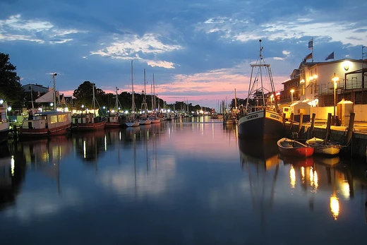
Nowadays, the Erie Canal is mostly used by recreational boats. It links the three other canals in the New York State Canal System: the Champlain, Oswego, and Cayuga–Seneca. Some long-distance boaters include it as part of the Great Loop route. The canal has also become a tourist draw, with many parks and museums dedicated to its history. The New York State Canalway Trail, a popular cycling path, follows the canal across the state. In 2000, Congress created the Erie Canalway National Heritage Corridor to protect and promote the system.
It’s worth noting that the waterway called the Erie Canal today is quite different from the 19th-century version. More than half of the original canal was destroyed or abandoned during the early 1900s construction of the New York State Barge Canal. The surviving sections, mostly west of Syracuse, were widened, bridges rebuilt, and locks replaced. It was known as the Barge Canal at the time, but that name faded as commercial traffic disappeared and recreational use grew in the later 20th century.
Before railroads, water transport was the cheapest way to move bulk goods. A mule could carry only about 250 pounds (110 kg) but could pull a barge weighing up to 60,000 pounds (27,000 kg) along a towpath, cutting transport costs by roughly 95 percent. In the early U.S., moving goods between coastal ports and the interior was slow and tough. Rivers near the coast offered easy travel up to the fall line, but the Appalachian Mountains—stretching 1,500 miles (2,400 km) from Maine to Alabama—posed a huge barrier, with only five places where mule trains or wagon roads could cross. Passengers and freight heading west had to go overland on rough roads. In 1800, it took about 2½ weeks to travel from New York to Cleveland, Ohio (460 miles; 740 km), and 4 weeks to Detroit (612 miles; 985 km).
The main export from the Ohio Valley was grain, a high-volume, low-price product. Often, shipping it to distant markets wasn’t worth the cost, which led farmers to turn grain into whiskey for easier transport and higher profits—a factor in the Whiskey Rebellion. By the 18th and early 19th centuries, coastal residents realized that any city or state that built a cheap, reliable route to the West would thrive economically, and the port at the route’s seaward end would boom. Projects were soon proposed in Virginia, Maryland, Pennsylvania, and other coastal states.
The Mohawk River, a tributary of the Hudson, rises near Lake Ontario and flows through a glacial meltwater channel just north of the Catskill Mountains, separating them from the Adirondacks. The Mohawk and Hudson valleys provide the only break in the Appalachians north of Alabama, making a navigable canal through the Mohawk Valley a natural choice.
- length_original
- 363 miles (584 km)
- length_modern
- 351 miles (565 km)
- width_original
- 40 feet (12 m)
- depth_original
- 4 feet (1.2 m)
- elevation_difference
- about 565 feet (172 m)
- number_of_locks
- 35
- peak_year
- 1855
Verified Timeline
Lore & Background
A canal from the Hudson River to the Great Lakes was first proposed in the 1780s, but a formal survey was not conducted until 1808. The New York State Legislature authorized construction in 1817. Political opponents of the canal, referring to its lead supporter New York Governor DeWitt Clinton, denigrated the project as 'Clinton's Folly' and 'Clinton's Big Ditch'. The canal saw quick success upon opening on October 26, 1825, with toll revenue covering the state's construction debt within the first year of operation. The westward connection gave New York City a strong advantage over all other US ports and brought major growth to canal cities such as Albany, Utica, Syracuse, Rochester, and Buffalo. The construction of the Erie Canal was a landmark civil engineering achievement in the early history of the United States. When built, the 363-mile (584 km) canal was the second-longest in the world after the Grand Canal in China. Initially 40 feet (12 m) wide and 4 feet (1.2 m) deep, the canal was expanded several times, most notably from 1905 to 1918 when the 'Barge Canal' was built and over half the original route was abandoned. The modern canal measures 351 miles (565 km) long, 120 feet (37 m) wide, and 12 feet (3.7 m) deep. It has 35 locks, including the Waterford Flight, the steepest locks in the United States. The overall elevation difference is about 565 feet (172 m). The Erie's peak year was 1855, when 33,000 commercial shipments took place. It continued to be competitive with railroads until about 1902, when tolls were abolished. Commercial traffic declined heavily in the latter half of the 20th century due to competition from trucking via the newly developed Interstate Highway System and the 1959 opening of the larger St. Lawrence Seaway. The canal's last regularly scheduled hauler, the Day Peckinpaugh, ended service in 1994.
Reader's Guide
The Erie Canal was a transformative infrastructure project that reshaped the economic and geographic landscape of the United States. By providing a cost-effective water route across the Appalachians, it slashed transport costs by about 95 percent and opened the Great Lakes region to settlement and commerce. The canal accelerated the westward expansion of the United States and cemented New York City's dominance as a port, while spurring growth in cities like Albany, Utica, Syracuse, Rochester, and Buffalo. Its success demonstrated the power of state-funded public works and inspired similar canal projects nationwide. Though commercial traffic declined after the rise of railroads, trucking, and the St. Lawrence Seaway, the Erie Canal remains in use today primarily for recreational boating. It connects three other canals in the New York State Canal System and is part of the Great Loop route for long-distance boaters. The canal has become a tourist attraction, with parks, museums, and the New York State Canalway Trail, a popular cycling path. In 2000, Congress designated the Erie Canalway National Heritage Corridor to protect and promote the system. The modern waterway differs significantly from the original, as more than half of the original route was destroyed or abandoned during the early 20th-century construction of the Barge Canal.
Did You Know?
- The Erie Canal was the second-longest canal in the world when built, after the Grand Canal in China.
- Toll revenue covered the state's construction debt within the first year of operation after opening on October 26, 1825.
- The Waterford Flight contains the steepest locks in the United States.
- The canal's last regularly scheduled hauler, the Day Peckinpaugh, ended service in 1994.
- More than half of the original Erie Canal route was destroyed or abandoned during construction of the New York State Barge Canal in the early 20th century.
More in Canals And Artificial Waterways 1-19
Related in Canals And Artificial Waterways
Links follow this subject's own source article.
Spotted an error? Know more?
This is a living reference — every entry is fact-audited, and reader corrections feed straight into our audit queue. Suggest an edit · See this site's audit record