
Where Northern sea urchin has been recorded
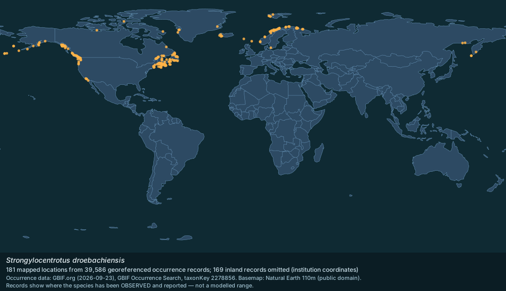
GBIF occurrence records for Strongylocentrotus droebachiensis, mapped and tabulated by country.

Distribution map plotted from GBIF.org occurrence records; basemap Natural Earth 110m · GBIF records CC0 / CC BY; Natural Earth public domain
39,586 georeferenced occurrence records with coordinates are published for Strongylocentrotus droebachiensis through GBIF, from 32 countries or marine areas. This page maps those records and lists where they come from. Occurrence records reflect where people have looked as well as where the species lives, so well-surveyed coastlines are over-represented.
- Georeferenced records
- 39,586
- Countries / areas
- 32
- Mapped locations
- 181
- Records sampled for the map
- 3,000
- Inland records omitted
- 169
- Gbif taxonkey
- 2278856
Countries and areas with the most records (GBIF)
Canada — 27,293 records; United States of America — 9,251 records; Norway — 1,405 records; Sweden — 495 records; Russian Federation — 330 records; Svalbard and Jan Mayen — 201 records; Denmark — 174 records; United Kingdom of Great Britain and Northern Ireland — 120 records; Greenland — 115 records; Iceland — 85 records; Saint Pierre and Miquelon — 29 records; Germany — 24 records; Mexico — 17 records; Faroe Islands — 9 records; Viet Nam — 4 records.
Source: GBIF Occurrence Search (taxonKey 2278856) — https://www.gbif.org/occurrence/search?taxon_key=2278856&has_coordinate=true (records CC0 / CC BY). Accessed 2026-09-23.
Marine regions with a WoRMS distribution record
European waters (ERMS scope); North West Atlantic; North Sea; British Isles; Channel Islands; Öresund; Belt Sea; Kattegat; Bohuslän; Norwegian Exclusive Economic Zone; White Sea; Kara Sea; Chuki Sea; Iceland; East Britain; Scotland; Shetlands; North East Coast of England; Northern North Pacific; Faroe Islands; Arctic Ocean; North Pacific; Cobscook Bay; Gulf of Maine; Canadian Exclusive Economic Zone [Arctic part]; Manicouagan; St. Lawrence Estuary; Saguenay Fjord; Gulf of St. Lawrence; Swedish Exclusive Economic Zone.
Source: WoRMS distribution records (MarineRegions) — https://www.marinespecies.org/aphia.php?p=taxdetails&id=124321 (CC BY 4.0). Accessed 2026-09-23.
How to read this map
The map plots a sample of 3,000 of the 39,586 records, deduplicated to a half-degree grid, so dense areas do not merge into one blob. The sample covers 11 of the 32 countries or areas with records; the areas absent from the sample hold 241 records in total (Denmark, Germany, Mexico, Viet Nam, Congo, Democratic Republic of the, Spain, Fiji, Indonesia).
169 records plotting inland were omitted: for a marine species those are almost always the holding institution's coordinates rather than a collection site.
Records show where the species has been observed and reported, not a modelled range.
Source: GBIF Occurrence Search (taxonKey 2278856) — https://www.gbif.org/occurrence/search?taxon_key=2278856&has_coordinate=true (records CC0 / CC BY); WoRMS distribution records (MarineRegions) — https://www.marinespecies.org/aphia.php?p=taxdetails&id=124321 (CC BY 4.0); Natural Earth 110m basemap — https://www.naturalearthdata.com/ (public domain). Accessed 2026-09-23.
Gallery
Related in Northern sea urchin
Links follow this subject's own source article.
Elsewhere in Northern sea urchin
Spotted an error? Know more?
Reader corrections go straight into our review queue. Suggest an edit · How this site is sourced