U.S. Army Corps of Engineers Bay Model
A working hydraulic model of San Francisco Bay and Delta.
Last updated
Where it is
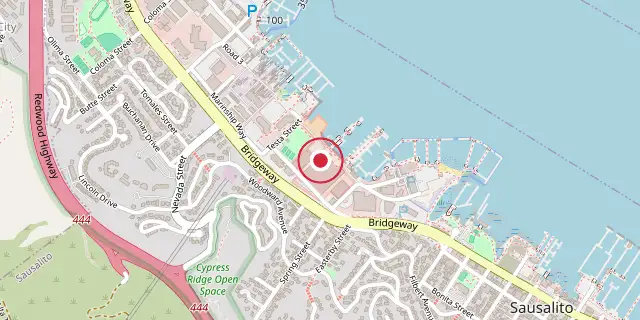
Coordinates: 37°51′50″N 122°29′42″W (37.8640, -122.4950) · Open in OpenStreetMap
Coordinates and connected clubs: the infobox of Wikipedia: U.S. Army Corps of Engineers Bay Model (CC BY-SA 4.0). Map: drawn by Codexery from OpenStreetMap tiles.
The Bay Model, built by the U.S. Army Corps of Engineers, is a working hydraulic scale model that replicates the San Francisco Bay and the Sacramento-San Joaquin River Delta System. Although it still functions, it is no longer used for scientific research; instead, it is open to the public at the Bay Model Visitor Center in Sausalito, California, alongside educational exhibits on Bay hydrology.
History
The model was constructed to test the Reber Plan, a proposal from the late 1940s by John Reber to build two large dams in the San Francisco Bay for a more reliable freshwater supply and to connect communities. In 1953, the Corps of Engineers proposed a detailed study of this plan, along with a similar one by Cornelius Biemond that would dam the Sacramento River in the delta to feed aqueducts. Authorized under Section 110 of the Rivers and Harbors Act of 1950, construction finished in 1957. The tests showed the plan was not viable, and it was abandoned.
Between 1966 and 1969, the Sacramento-San Joaquin River Delta portion was added to study the effects of deepening navigation channels, realigning Delta channels (including the Peripheral Canal), and various flow arrangements on water quality. When completed, the expanded model covered two acres.
Size and scope
The model measures roughly 320 feet north-south and 400 feet east-west, built from 286 five-ton concrete slabs fitted together like a jigsaw puzzle. It reproduces features affecting water flow, such as ship channels, rivers, creeks, sloughs, Delta canals, fills, major wharfs, piers, slips, dikes, bridges, and breakwaters. Its limits extend 17 miles beyond the Golden Gate into the Pacific Ocean, and include San Francisco Bay, San Pablo Bay, Suisun Bay, and the entire Sacramento-San Joaquin River Delta up to Verona (17 miles north of Sacramento) and down to Vernalis (32 miles south of Stockton on the San Joaquin River).
Scale
The model uses a horizontal scale of 1:1000 and a vertical scale of 1:100, with a time scale of 1:100. This tenfold vertical distortion is intentional to ensure proper hydraulic flow over tidal flats and shallows, but it increases hydraulic efficiency. Copper strips throughout the model correct for these increased efficiencies, with the exact number adjusted during calibration.
Lore & Background
In the late 1940s, John Reber proposed building two large dams in San Francisco Bay to provide a more reliable freshwater supply and connect communities. The U.S. Army Corps of Engineers began a detailed study of the Reber Plan in 1953, and construction of the Bay Model was authorized under Section 110 of the Rivers and Harbors Act of 1950. Completed in 1957, the model was used to test the plan, and the tests proved it not viable, leading to its abandonment. Cornelius Biemond proposed a similar plan to dam the Sacramento River in the delta region to feed aqueducts with freshwater.
The Sacramento-San Joaquin River Delta portion was added between 1966 and 1969 to study impacts of deepening navigation channels, realignment of delta channels via the Peripheral Canal, and various flow arrangements on water quality. The model is constructed from 286 five-ton concrete slabs joined like a jigsaw puzzle. It reproduces features affecting water flow, including ship channels, rivers, creeks, sloughs, delta canals, fills, major wharfs, piers, slips, dikes, bridges, and breakwaters. Its limits extend 17 miles beyond the Golden Gate into the Pacific Ocean, and inland to Verona north of Sacramento and Vernalis south of Stockton.
The model uses a distorted scale: 1:1000 horizontally and 1:100 vertically, with a time scale of 1:100. The tenfold distortion ensures proper hydraulic flow over tidal flats and shallows but increases hydraulic efficiency, which is corrected by copper strips placed throughout the model. The exact number of strips is adjusted during calibration.
Reader's Guide
The Bay Model's primary significance lies in its role in disproving the Reber Plan, a major proposed engineering project for San Francisco Bay. By demonstrating the plan's lack of viability, the model saved substantial resources and prevented potentially detrimental alterations to the bay's hydrology.
Its later expansion to include the Sacramento-San Joaquin River Delta allowed the Corps to study the effects of channel deepening, the Peripheral Canal, and other flow arrangements on water quality, informing decisions about delta management. Although no longer used for scientific research, the model remains operational and is open to the public at the Bay Model Visitor Center, where educational exhibits explain bay hydrology. It stands as a notable example of large-scale physical modeling used for civil engineering and environmental planning, and it is complemented by a larger model of the Chesapeake Bay built by the Corps in 1976.
Frequently Asked Questions
What is the U.S. Army Corps of Engineers Bay Model?
It is a working hydraulic scale model that recreates San Francisco Bay and the Sacramento-San Joaquin River Delta system. The Corps built it to simulate real-world water flow and tidal behavior at a reduced size so engineers could study the estuary's dynamics.
Why was the Bay Model originally constructed?
The Corps built it in the late 1940s and completed it in 1957 to physically test the Reber Plan, a proposal by engineer John Reber to place two large dams across the Bay to secure a steadier freshwater supply and improve regional connectivity. The model let researchers observe how such structures would alter tidal and riverine flows before committing to construction.
Where can the public visit the Bay Model today?
It is located at the Bay Model Visitor Center at 2100 Bridgeway Blvd. in Sausalito, California. Although it is no longer used for active scientific research, the site remains open to visitors and features educational exhibits on Bay hydrology alongside the still-functioning model.
More in Scale Models and Railroads
Sources
Compiled from Wikipedia and the sources listed below. Text from Wikipedia is available under CC BY-SA 4.0; this entry is adapted from it.
- Wikipedia: U.S. Army Corps of Engineers Bay Model (CC BY-SA 4.0).
Spotted an error? Know more?
Reader corrections go straight into our review queue. Suggest an edit · How this site is sourced