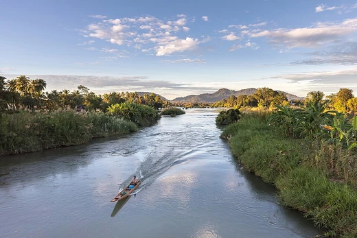
White Nile
Longer but less voluminous tributary of the Nile.

via Wikipedia: White Nile · see source
The White Nile flows through North and East Africa. It carries less water than the Blue Nile, the other major branch of the Nile, but it is longer, wider, and shallower. Its pale color comes from clay sediment suspended in the water. Strictly speaking, the White Nile begins at Lake No, where the Bahr al Jabal and Bahr el Ghazal rivers meet. More broadly, the name covers all the river sections that drain from Lake Victoria to the point where it joins the Blue Nile: the Victoria Nile (from Lake Victoria through Lake Kyoga to Lake Albert), then the Albert Nile (to the South Sudan border), and then the Mountain Nile, or Bahr-al-Jabal, down to Lake No. Sometimes the term also includes Lake Victoria’s headwaters; the most distant of these is about 3,700 kilometers from the Blue Nile.
The river’s longest feeder into Lake Victoria is the Kagera River, which enters the lake near Bukoba, Tanzania. Sources disagree on which tributary of the Kagera is longest, so the Nile’s ultimate source could be either the Ruvyironza in Burundi or the Nyabarongo in Rwanda. These two streams meet near Rusumo Falls on the Rwanda–Tanzania border. At that spot, on 28–29 April 1994, about 250,000 Rwandans crossed the bridge into Tanzania in 24 hours—the United Nations High Commissioner for Refugees called it the largest and fastest refugee exodus in modern times. The Kagera then forms parts of the Rwanda–Tanzania and Tanzania–Uganda borders before flowing into Lake Victoria.
In Uganda, the river is first called the Victoria Nile. It begins at the outlet of Lake Victoria near Jinja, on the lake’s northern shore. Downstream from the Nalubaale and Kiira power stations, it passes over Bujagali Falls about 15 kilometers from Jinja, where the Bujagali Power Station is located. The river then flows northwest through Lake Kyoga and continues west to Lake Albert. At Karuma Falls, it passes under Karuma Bridge, built in 1963 to support the cotton industry. During the Lord’s Resistance Army insurgency, this bridge was a key stop on the road to Gulu, where vehicles gathered in convoys before receiving a military escort north. In 2009, Uganda announced plans for a 750-megawatt hydropower project north of the bridge, scheduled for completion in 2016; the World Bank had approved funding for a smaller 200-megawatt plant, but Uganda chose the larger project, which it said it would fund internally if needed. Just before entering Lake Albert, the river narrows to just seven meters wide at Murchison Falls, marking its entry into the western branch of the East African Rift. It then flows into Lake Albert opposite the Blue Mountains in the Democratic Republic of the Congo. The stretch from Lake Kyoga to Lake Albert is sometimes called the Kyoga Nile.
From Lake Albert northward, the river is called the Albert Nile. It separates Uganda’s West Nile sub-region from the rest of the country. A bridge crosses the Albert Nile near its inlet in Nebbi District, but no other bridge exists on this section. A ferry connects roads between Adjumani and Moyo; otherwise, travel on the river is by small boat or canoe.
When the river enters South Sudan from Uganda, it becomes the Mountain Nile, or Bahr al-Jabal (Arabic for “Mountain River”). From Nimule near the Ugandan border, it passes through several rapids before reaching the Sudan plain and the vast Sudd swamp. It continues to Lake No, where it meets the Bahr el Ghazal and becomes the White Nile in the strict sense. An anabranch called the Bahr el Zeraf splits from the Bahr al-Jabal, flows through the Sudd, and later rejoins the White Nile. The Mountain Nile also cascades through narrow gorges and rapids, including the Fula (Fola) Rapids.
From Lake No, the White Nile flows east for about 120 kilometers to the mouth of the Sobat River. This section has a very gentle slope and contains many swamps and lagoons. When the Sobat is in flood, it carries heavy sediment, adding to the White Nile’s pale color. From Malakal, South Sudan’s second city, the river runs slowly but without swamps into Sudan and north to Khartoum. Downstream from Malakal lies Kodok, site of the 1898 Fashoda Incident, which marked the end of the Scramble for Africa. In Sudan, the river gives its name to the state of White Nile.
- length
- 3,700 km (2,300 mi) from the most remote headwaters of Lake Victoria to the Blue
- source
- Lake Victoria (via the Kagera River and its tributaries, with disputed most dist
- confluence
- Joins the Blue Nile at Khartoum, Sudan, to form the River Nile
- key tributaries
- Bahr al Jabal, Bahr el Ghazal, Sobat River
- navigable stretch
- From Lake Albert to Khartoum via the Jebel Aulia Dam
Verified Timeline
Lore & Background
The White Nile's headwaters begin with the Kagera River, which flows into Lake Victoria near the Tanzanian town of Bukoba. The Kagera is the longest feeder river for Lake Victoria, though sources do not agree on which is the longest tributary of the Kagera, and hence the most distant source of the Nile. The source can be considered either the Ruvyironza, which emerges in Bururi Province, Burundi (near Bukirasaz), or the Nyabarongo, which flows from Nyungwe Forest in Rwanda. These two feeder rivers meet near Rusumo Falls on the border between Rwanda and Tanzania. These waterfalls are known for an event on 28–29 April 1994, when 250,000 Rwandans crossed the bridge at Rusumo Falls into Ngara, Tanzania, in 24 hours, in what the United Nations High Commissioner for Refugees called 'the largest and fastest refugee exodus in modern times'. The Kagera forms part of the Rwanda–Tanzania and Tanzania–Uganda borders before flowing into Lake Victoria. From Lake Victoria, the river flows as the Victoria Nile through Uganda, passing over Bujagali Falls about 15 km downstream from Jinja, and through Lake Kyoga before reaching Lake Albert. At Murchison Falls, just before entering Lake Albert, the river is compressed into a passage just seven meters wide, marking its entry into the western branch of the East African Rift.
Reader's Guide
The White Nile is significant as the longer of the Nile's two main tributaries, providing a crucial waterway through Uganda, South Sudan, and Sudan. Its pale color, caused by clay sediment, distinguishes it from the Blue Nile. The river's course includes the vast Sudd swamp in South Sudan, which slows its flow, and the Sobat River tributary, which carries a large amount of sediment when in flood, adding greatly to the White Nile's pale color. Historically, the White Nile was central to the 1898 Fashoda Incident at Kodok, which marked an end to the Scramble for Africa. The White Nile is a navigable waterway from Lake Albert to Khartoum via the Jebel Aulia Dam, though only between Juba and Uganda requires the river upgrade or channel to make it navigable. During part of the year the rivers are navigable up to Gambela, Ethiopia, and Wau, South Sudan. The river also lends its name to the Sudanese state of White Nile, before joining the larger Blue Nile at Khartoum to form the River Nile. Its disputed source—either the Ruvyironza or Nyabarongo—reflects ongoing geographical uncertainty.
Did You Know?
- The name 'White Nile' comes from the clay sediment carried in the water, which gives the water a pale color.
- At Murchison Falls, the river is compressed into a passage just seven meters wide before entering Lake Albert.
- On 28–29 April 1994, 250,000 Rwandans crossed the bridge at Rusumo Falls into Tanzania in 24 hours, called 'the largest and fastest refugee exodus in modern times' by the UNHCR.
- The 1898 Fashoda Incident at Kodok marked an end to the Scramble for Africa.
- The Sobat River tributary carries a large amount of sediment when in flood, adding greatly to the White Nile's pale color.
Frequently Asked Questions
What is the White Nile?
The White Nile is a major river running through East and North Africa and one of the two principal tributaries feeding the Nile. It is the longer of the pair but carries noticeably less water volume than the Blue Nile.
Why is it called the "White" Nile?
The name refers to the pale clay sediment suspended in its current, which gives the water a light, milky hue. This visual distinction is what separates it from the darker Blue Nile.
Where does the White Nile start and where does it end?
Its most distant headwaters trace back to Lake Victoria through the Kagera River system, though the exact farthest source remains a matter of debate. The river ultimately meets the Blue Nile at Khartoum, Sudan, and the two together form the main Nile.
How long is the White Nile?
Stretching roughly 3,700 km (about 2,300 miles) from its farthest source at Lake Victoria to its junction with the Blue Nile, it outpaces the Blue Nile in length while trailing behind in water volume.
How does the White Nile compare to the Blue Nile?
The White Nile is longer, wider, and shallower, with a pale, clay-tinted current, whereas the Blue Nile is shorter but carries far greater volume and a darker color. They converge at Khartoum to create the Nile as we know it.
More in Rivers 1-16
Spotted an error? Know more?
This is a living reference — every entry is fact-audited, and reader corrections feed straight into our audit queue. Suggest an edit · See this site's audit record