Beas River
Smallest of the five major Punjab rivers, rising in the Himalayas.

via Wikipedia: Beas River · see source
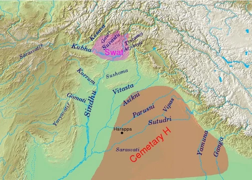
The Beas River, known in the Rigveda as Vipāś, is a river in northwestern India flowing through Himachal Pradesh and Punjab. It is the smallest of the five major rivers of the Punjab region and rises in the Himalayas in central Himachal Pradesh. The river is notable for marking the easternmost limit of Alexander the Great's conquests and for hosting a tiny isolated population of the Indus dolphin.
Quick Facts
- Length (km)
- 470
- Source location
- Himalayas, Himachal Pradesh
- Mouth
- Sutlej River
- Mouth location
- Harike, Harike Wetland, Tarn Taran district, Punjab
- Other names
- Vyas River
Facts from the source article.
Etymology
Later Sanskrit texts refer to it as Vipāśā, and Yāska identifies it with Argrikiya. According to legend, Veda Vyasa is the eponym of the Beas, said to have created it from Beas Kund. Another legend holds that before Vyasa, the river was known as Saraswati; Rishi Vashishta, after trying to drown himself tied with cords, was saved when the river became a sandbed and broke the cords, leading him to name it Vipasa (cord-breaker). Ancient Greeks called it Hyphasis; Plinius used Hypasis. Other classical names include Hynais, Bipasis, and Bibasis. In modern times it has been called Bias or Bejah.
History
The Beas River marked the easternmost border of Alexander the Great's conquests in 326 BC. His troops mutinied at Mukerian, refusing to go further east, and Alexander eventually gave in, raising twelve colossal altars to mark the limit of his expedition; the altars' location is unknown, though one historian suggested they were later reused for some Pillars of Ashoka. According to the Kavyamimansa of Rajasekhara, the kingdom of Gurjara-Pratihara monarch Mahipala I extended to the upper course of the Beas in the north-west. In 2014, the Beas River Tragedy occurred when 24 engineering students and one tour operator drowned after flood gates of the Larji dam were opened. During the 2023 monsoon, flooding caused substantial damage in Himachal Pradesh, with estimated damage of $1 billion and over 400 lives lost.
Course
The Beas River begins its journey at an elevation of 4,361 meters on the southern side of the Rohtang Pass in Kullu. It flows through Mandi District and enters Kangra District at Sandhol, which sits at 590 meters above sea level. Along its lower stretch, the river is crossed by many ferries, often made from inflated animal skins called darais. Near Reh in Kangra District, the Beas splits into three separate channels that come back together after passing Mirthal, at an elevation of 300 meters.
When it reaches the Sivalik Hills in Mukerian, the river makes a sharp turn to the north, creating the boundary with Kangra District. It then curves around the base of the Sivalik Hills and heads south, forming the border between Gurdaspur and Hoshiarpur districts. After a short stretch along the Jalandhar district, it marks the boundary between Amritsar and Kapurthala. The Beas finally meets the Sutlej River at the southwestern edge of Kapurthala district, after covering a total distance of 470 kilometers.
Its main tributaries are the Bain, Banganga, Luni, and Uhal. The Sutlej continues into Pakistani Punjab and joins the Chenab at Uch near Bahawalpur to form the Panjnad, which then flows into the Indus at Mithankot. Under the Indus Waters Treaty, India has rights to the Beas’s water, which has a mean annual flow of 14.203 million acre feet. Historically, the Beas once ran from its current meeting point with the Sutlej toward Lahore and Montgomery districts, joining the Chenab near Shujabad before the Chenab turned west.
By 1245, it had taken over the old Chenab riverbed that passed by Dipalpur, and it used to flow from Kasur to Chunian and then to Shergarh in Okara. The ancient Beas also ran south of the Harappa site. Between 1750 and 1800, after many earlier course changes, the river shifted and was captured by the Sutlej.
Dams
In the 20th century, the Beas was developed under the Beas Project for irrigation and hydroelectric power. Listed upstream to downstream: Pandoh Dam (Beas Satluj Link Project I), 990 MW, 41 MCM, in Mandi district, diverts water to the Sutlej River through tunnels and channels. Pong Dam (Beas Dam / Maharana Pratap Sagar), 396 MW, 8570 MCM, in Kangra district, is an earth-fill dam completed in 1974 for water storage, irrigation, and power. Shahnehar Barrage/Headwork, 207 MW, 4.64 MCM live capacity, just downstream of Pong Dam in Kangra district, was completed in 1983; the Shahnehar Canal takes off from it for irrigation and four cascading power houses.
Harike Barrage, 45 km northeast of Ferozepur in Ferozepur district near the Pakistan border, is at the confluence of the Beas and Sutlej for diverting water into canals for irrigation in Rajasthan and Punjab, including the Indira Gandhi Canal and Ganga Canal (Rajasthan).
More in Rigvedic Rivers
Spotted an error? Know more?
Reader corrections go straight into our review queue. Suggest an edit · How this site is sourced