
Height above mean sea level
Vertical distance referenced to historic mean sea level.

NASA/JPL-Caltech · Public domain
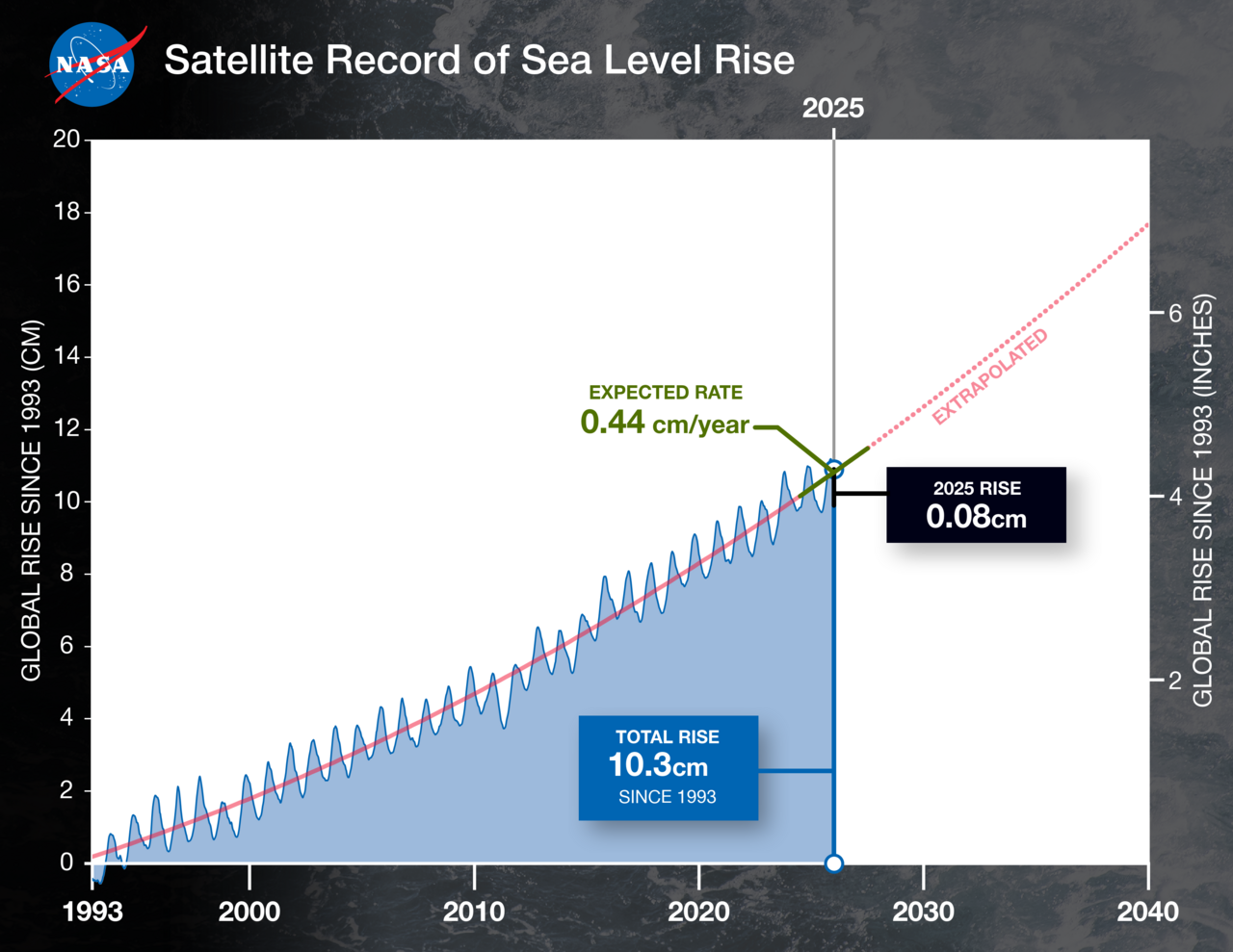
Height above mean sea level describes how high a point is measured vertically from a baseline set by the average level of the ocean at a particular time in history. In geodesy, this is known as orthometric height. Because different countries use different reference points and historical periods to define that baseline, the zero mark can vary from place to place. Sea levels and land elevations also shift over time due to climate change and other natural forces.
This measurement is commonly used for towns, mountains, landmarks, the tops of buildings and structures, mining sites (especially underground), and for aircraft like airplanes and helicopters below a locally defined transition altitude.
In the metric system, it is usually given as "metres above mean sea level," while in U.S. customary and imperial units it is "feet above mean sea level." Common abbreviations include AMSL, AOD, AODN, ASL, FAMSL, FASL, MAMSL, MASL, and MSL. Often just "MSL" is used—for example, Mount Everest (8849 m MSL)—or the sea-level reference is dropped entirely, as in Mount Everest (8849 m).
Altimetry is the science of measuring this height. Techniques include surveying (especially levelling), Global Navigation Satellite Systems (like GPS) that need a geoid to convert a 3D position to sea-level elevation, pressure altimeters that rely on atmospheric pressure (which decreases with altitude and must be calibrated with a recent local pressure reading at a known height), stereoscopy in aerial photos, aerial lidar and satellite laser altimetry, and aerial or satellite radar altimetry.
Accurately measuring historical mean sea levels is tricky. Land subsidence in some regions can make sea levels appear to rise, while uplift from geological processes can suggest a relative drop in mean sea level.
- measurement_type
- Vertical distance relative to historic mean sea level
- common_units
- Metres (metric) or feet (US customary/imperial)
- abbreviations
- AMSL, ASL, MASL, MSL, etc.
- uses
- Geographic locations, buildings, mining, flying objects below transition altitude
- measurement_methods
- Surveying, GNSS, pressure altimeter, stereoscopy, lidar, radar altimetry
Lore & Background
Height above mean sea level quantifies the vertical distance of a location relative to a vertical datum established from a historical average of sea level. In geodesy, this measurement is formally termed orthometric height. The baseline or zero level is not globally uniform; it differs between countries because each nation historically selected its own reference point and measurement period. Climate change and other natural forces can cause both sea levels and land elevations to shift over time, meaning the reference is not static. This measure is commonly expressed in metres (metres above mean sea level, or MAMSL) in the metric system, or in feet (feet above mean sea level, or FAMSL) under United States customary and imperial units. Common abbreviations include AMSL, ASL, and MSL; for instance, a mountain’s height may be given simply as a number followed by “MSL.” Altimetry, the science of measuring such altitude, employs several techniques. Surveying methods like levelling provide direct measurement. Global Navigation Satellite Systems, such as GPS, determine a three-dimensional position that must be converted to sea-level elevation using a geoid model. Pressure altimeters measure atmospheric pressure, which decreases with altitude, but require recent local calibration against a known elevation due to weather-related pressure changes. Other methods include stereoscopy from aerial photography, aerial lidar, satellite laser altimetry, and radar altimetry from aircraft or satellites. Accurate historical sea-level measurement is complicated by land subsidence, which can mimic rising seas, and by geological uplift, which can suggest a relative drop in sea level.
Reader's Guide
Height above mean sea level is a fundamental geodetic concept used to express elevation or altitude. It is formalized as orthometric height and is measured using various techniques including surveying, Global Navigation Satellite Systems (such as GPS), pressure altimeters, stereoscopy in aerial photography, aerial lidar and satellite laser altimetry, and aerial or satellite radar altimetry. Accurate measurement of historical mean sea levels is complex; land mass subsidence can give the appearance of rising sea levels, while uplifted land masses can suggest a relative lowering of mean sea level. Climate change and other forces can cause sea levels and elevations to vary over time, making the reference datum subject to change. The measurement is expressed in metres above mean sea level in the metric system, or feet above mean sea level in United States customary and imperial units.
Did You Know?
- The zero level for height above mean sea level varies in different countries due to different reference points and historic measurement periods.
- Climate change and other forces can cause sea levels and elevations to vary over time.
- Land mass subsidence can give the appearance of rising sea levels, while uplifted land masses can suggest a relative lowering of mean sea level.
- Common abbreviations include AMSL (above mean sea level), ASL (above sea level), and MSL (mean sea level).
Definition and Geodetic Foundation
Height above mean sea level quantifies how far a point on Earth's surface sits vertically above a reference plane tied to a historically observed average ocean level. In the field of geodesy, this concept carries a precise formal name: orthometric height. What makes the system inherently local is that the zero reference is not universal. Different nations have adopted different reference points and different historical measurement windows, so the baseline against which elevation is calculated shifts from one country to the next. Adding another layer of complexity, the reference itself is not frozen in time. Climate change and other natural forces cause both sea levels and land elevations to drift over decades and centuries, meaning a value recorded in one era may not perfectly match a value determined in another. This temporal variability means the datum is, in a practical sense, a snapshot of a dynamic system rather than an absolute constant.
Practical Applications Across Industries
The elevation or altitude of a point above sea level serves as a standard, widely recognized measurement across a surprising range of fields. In everyday geography, it is the go-to figure for describing the position of towns, mountains, and other natural or man-made landmarks. Urban planners and engineers rely on the same metric to specify the height of the top of buildings and other structures. In the mining industry, particularly for underground operations, knowing the precise elevation relative to sea level is critical for infrastructure planning and safety. Aviation is another major domain: pilots of airplanes and helicopters reference mean sea level altitude when flying below a transition altitude set by local regulations. Above that threshold a different reference system takes over, but below it the sea-level datum remains the common language for vertical positioning in the sky.
Methods of Measuring Altitude
The discipline of altimetry encompasses several distinct techniques for determining a location's elevation above sea level. Traditional surveying, especially the method of levelling, remains a foundational approach. Modern Global Navigation Satellite Systems, including GPS, allow a receiver to compute its three-dimensional position by processing pseudoranges from multiple satellites; however, converting that 3D position into a sea-level elevation requires knowledge of the geoid. A pressure altimeter offers a more portable solution by reading atmospheric pressure, which generally decreases as altitude increases, though because pressure also fluctuates with weather, the instrument must be calibrated against a recent local pressure reading taken at a known altitude. Stereoscopic analysis of aerial photographs provides yet another avenue. More recently, aerial and satellite lidar, along with satellite radar altimetry, have added high-precision remote-sensing capabilities to the toolkit.
Units, Abbreviations, and Conventions
Expressing elevation above sea level follows a straightforward pattern in both the metric and imperial systems: metres above mean sea level or feet above mean sea level, respectively. In practice, English-language documentation employs a rich set of abbreviations to keep labels compact. AMSL and ASL are the most common shorthand for above mean sea level and above sea level. When the reference is specifically an ordnance datum, AOD or AODN appears. Unit-specific forms such as FAMSL, FASL, MAMSL, and MASL make the measurement system explicit. The bare abbreviation MSL is frequently used on its own, as in the widely cited figure for Mount Everest at 8849 m MSL, or the reference to sea level is dropped entirely, yielding simply 8849 m. This flexibility in notation reflects the convention's deep integration into cartography, aviation charts, and scientific literature, where brevity and clarity are both prized.
Gallery
Frequently Asked Questions
What is Height above mean sea level?
It is a vertical-distance measurement that tells you how far a point sits above a reference plane tied to a historically averaged sea level. In geodesy the concept is formalized as orthometric height and underpins topographic mapping, aviation altitude reporting, and a wide range of engineering work.
What abbreviations and units do people use for Height above mean sea level?
You will commonly encounter AMSL, ASL, MASL, or simply MSL, expressed in metres across most of the world and in feet under the US customary (imperial) system.
How is Height above mean sea level actually measured in the field?
Geodesists and surveyors draw on traditional leveling, GNSS receivers, pressure altimeters, stereoscopic photogrammetry, lidar, and radar altimetry. The chosen method depends on the required precision, terrain, and budget of the project.
Why does the 'zero' for Height above mean sea level differ from one country to another?
Each nation historically anchored its vertical datum to a local tide-gauge station and a specific measurement window, so the reference plane is not globally uniform. As a result, the same physical point can carry slightly different elevation values in neighbouring countries.
Why does Height above mean sea level matter in everyday practice?
It is the standard vertical reference for locating geographic points, setting building and mining regulations, and reporting aircraft altitude below the transition altitude. Because climate change and tectonic activity can shift both sea level and land elevation over time, the datum is a living reference rather than a permanently fixed one.
More in Physical Geography & Elevation 1-24
Spotted an error? Know more?
This is a living reference — every entry is fact-audited, and reader corrections feed straight into our audit queue. Suggest an edit · See this site's audit record