Ruins of Gedi
Medieval Swahili ruins in Kenya's Arabuko-Sokoke Forest.
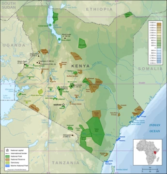
The Ruins of Gedi are a UNESCO World Heritage site on Kenya's Indian Ocean coast, within the Arabuko-Sokoke Forest. The site preserves the remains of a medieval Swahili walled town, including mosques, a palace, and houses built from coral stone. Gedi is one of the most extensively excavated Swahili coastal settlements, providing key insights into Indian Ocean trade and Swahili culture.
Quick Facts
- Location
- Kilifi County, Kenya
- Owner
- Kenyan Government
- Cultures
- Swahili
- Condition
- Protected
Facts from the source article.
Did You Know?
- The earliest evidence of occupation at Gedi is a grave marker radiocarbon dated to between 1041 and 1278.
- Gedi was made a historic monument in 1927 and a protected monument in 1929 after looters removed Chinese porcelain inset as architectural decoration.
- A museum funded by the European Union opened at the site in 2000, featuring a permanent display on Swahili culture.
History of discovery and excavation
The Gedi ruins were known to the local Mijikenda peoples, particularly the Giriama, who regard the site as sacred and believe it is protected by ancestral spirits. Sir John Kirk, a British resident of Zanzibar, first visited the site in 1884, but it remained obscure until its rediscovery in the 1920s. Initial excavations began in the late 1940s under James Kirkman, who supervised work from 1948 to 1958, with intermittent excavations continuing into the 1980s. Kirkman excavated the palace, several mosques, and houses, and cleared and repaired the walls. The Great Mosque was excavated in 1954, and the palace in 1963. His report on the Great Mosque was followed by a series of monographs and papers. The site remains one of the most intensely studied Swahili Coast settlements, used to understand Swahili culture, Indian Ocean trade, the spread of Islam, and political and economic ties among Swahili communities.
Architecture
Deep in the primeval Arabuko-Sokoke Forest, the Gedi ruins span 45 acres, split by two walls. An outer wall encloses the full 45 acres, while an inner wall encircles 18 acres. Inside the inner wall lie the urban core: two mosques, a palace or Sheikh's house, four large houses, several clustered houses, and four large pillar tombs. Also within this inner wall are four more houses and three additional mosques. Between the two walls, only two mosques stand as stone structures. Just beyond the outer wall, one mosque and several unidentified buildings remain. The town was laid out on a grid of streets, with sumps for storm water and lavatories in many main buildings. Most homes were thatched-roofed mud dwellings, but the surviving structures are built from coral stone quarried from the Indian Ocean. All buildings are single-story, with walls of lime mortar and foundations rarely deeper than a foot. Doorways are square-framed pointed archways, while tombs and mosques feature spandrels and architraves carved or inlaid with porcelain.
Material culture
Excavations have uncovered numerous artifacts, most abundantly beads and ceramics, used to identify trade and date the site's occupation. Stone houses are named after objects found within them, including two Chinese coins, a porcelain bowl, scissors, a Venetian bead, cowrie shells, an iron lamp, and an iron box. Material remains at Gedi are similar to those at adjacent Swahili coastal settlements, with greatest variation in pottery styles. Before the fifteenth century, Gedi, Ungwana, and Kilepwa had nearly identical remains; from the fifteenth through seventeenth centuries, sites including Mnarani, the Pillar Tomb at Malindi, Takwa, Kinuni, and Kilindidni showed increasingly similar material culture. Indian Ocean trade, growing from the seventh century, contributed to the presence of imported goods. Cowrie shells, found in greater abundance than struck coins, may have been the principal currency; Kirkman estimated their exchange rate at 400,000 to 1 gold dinar. Beads may also have served as currency, with a decline in their numbers in upper layers suggesting a drop in value around the fifteenth century.
Economy
Local industries likely included pottery production, metal working, construction, spinning and weaving cloth, fishing, trade, and possibly salt production. Coral architecture using limestone mortar indicates associated trades. Food production involved a mixed economy of livestock, agriculture, and horticulture, with some foods introduced through trade. Available crops included millet, African rice, cocoyam, coconuts, bananas, citrus fruits, pomegranates, figs, sugar cane, cotton, and various vegetables; principal livestock was likely cattle, with sheep, goats, and chickens also important. Small settlements established between the fourteenth and sixteenth centuries near Gedi—including sites at Mida Creek, Kiburugeni, Watamu, Shaka, and Kilepwa—are thought to have been agricultural communities that supplied most of Gedi's produce.
Frequently Asked Questions
Where is Ruins of Gedi?
Ruins of Gedi is located in Kilifi County, Kenya.
Who owns Ruins of Gedi?
Ruins of Gedi is owned by Kenyan Government.
More in National Parks of Kenya
Spotted an error? Know more?
Reader corrections go straight into our review queue. Suggest an edit · How this site is sourced