Mount Emei
Highest of China's Four Sacred Buddhist Mountains, home to Samantabhadra.
Last updated
Where it is
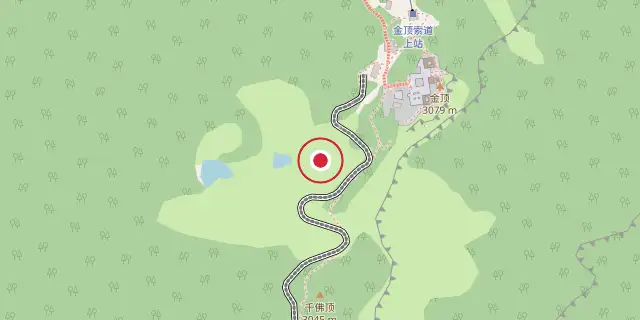
Coordinates: 29°31′12″N 103°19′55″E (29.5200, 103.3320) · Open in OpenStreetMap
Coordinates and connected clubs: the infobox of Wikipedia: Mount Emei (CC BY-SA 4.0). Map: drawn by Codexery from OpenStreetMap tiles.
In China's Sichuan Province, Mount Emei reaches 3099 m in elevation and ranks as the tallest among the country's Four Sacred Buddhist Mountains.[1]
Geography and history
A large surrounding area is geologically known as the Permian Emeishan Large Igneous Province.[2] The first Buddhist temple in China was built here in the 1st century CE.[3][4] Cable cars ease the ascent to the two temples at Jinding, an hour's hike from the mountain's peak.[5] The Sichuan Basin's western edge is where Mount Emei is positioned.[1]
To the west of Mount Emei lies the Daxiangling mountain range.[2] Emeishan City, a county-level municipality under Leshan's prefecture-level administration, is the nearest settlement to Mount Emei.[3] Seventy-six Buddhist monasteries dating from the Ming and Qing dynasties are found at this location, with the majority situated close to the summit.[3] The architectural style of these monasteries is adaptable, designed to fit the surrounding terrain.[6]
Certain halls, like those at Baoguosi, are constructed on stepped terraces, whereas other buildings, such as those at Leiyinsi, are elevated on stilts.[6] The meandering trail stretches for 50 km, requiring multiple days to complete on foot.[6]
What the cited sources add
The World Heritage Datasheet states that Mount Emei is where Buddhism first became established on Chinese territory and from where it spread widely throughout the east.[4] The same source notes that the three summits of Mount Emei form a characteristic landscape when viewed from a distance.[4] According to the World Heritage Datasheet, the mean annual precipitation is 1,992mm and the mountain is frequently covered in dense cloud or fog.[4] The vegetation grows in five belts defined by altitude, from subtropical evergreen broad-leaved forest below 1,500m to subalpine shrubland above 2,800m.[4]
Some 3,200 plant species in 242 families have been recorded, with more than 100 species endemic.[4] The World Heritage Datasheet reports that about 300,000 visitors, mostly Chinese, visit the summit yearly.[4] The "Abies fabri" account notes that acid rain appears to be the most serious threat to that species on Emei Shan.[7]
References
- Wikipedia, "Mount Emei" (CC BY-SA 4.0), which cites: Hayes, Holly (2009) Emei Shan, Sacred Destinations. Updated 24 July 2009. (we also read that source) en.wikipedia.org
- Wikipedia, "Mount Emei" (CC BY-SA 4.0), which cites: E.g., 实用中国地图集 (Shiyong Zhongguo Dituji, "Practical Atlas of China"), 2008, ; map of Sichuan on pp. 142–143 (original not read by us) en.wikipedia.org
- Wikipedia, "Mount Emei" (CC BY-SA 4.0), which cites: "Mount Emei Scenic Area, including Leshan Giant Buddha Scenic Area", UNESCO (original not read by us) en.wikipedia.org
- "Mount Emei Scenic Area, Including Leshan Giant Buddha Scenic Area", World Heritage Datasheet, May 2011. facts only, no text reused. world-heritage-datasheets.unep-wcmc.org
- Wikipedia, "Mount Emei" (CC BY-SA 4.0), which cites: Hayes, Holly (2009) Emei Shan, Sacred Destinations. Updated 24 July 2009.; Gluckman, Ron (2002). Getting to the Top, Silk Road, December 2002. Hong Kong; Dragon Airlines. (we also read that source) en.wikipedia.org
- Wikipedia, "Mount Emei" (CC BY-SA 4.0), which cites: Dazhang, "Chinese Architecture -- The Qing Dynasty", Yale University Press, 2002, p. 328–329 (we also read that source) en.wikipedia.org
- "Abies fabri Threatened Conifers of the World (en-GB)", threatenedconifers.rbge.org.uk. facts only, no text reused. threatenedconifers.rbge.org.uk
Each numbered sentence above was checked against the source it cites before publication. Sentences citing Wikipedia adapt text from the English Wikipedia article Mount Emei (contributors), used under CC BY-SA 4.0; this entry is available under the same licence. Other sources were used for facts only; no text or images are copied from them.
More in National parks of China
Sources
Compiled from Wikipedia and the sources listed below. Text from Wikipedia is available under CC BY-SA 4.0; this entry is adapted from it.
- Wikipedia: Mount Emei (CC BY-SA 4.0).
Spotted an error? Know more?
Reader corrections go straight into our review queue. Suggest an edit · How this site is sourced