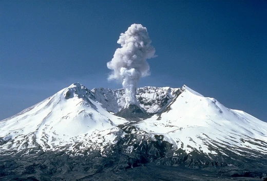
2004–2008 volcanic activity of Mount St. Helens
A continuous dome-building eruption from 2004 to 2008.
From October 2004 to January 2008, Mount St. Helens in Washington experienced a continuous eruption. Magma slowly pushed up, gradually forming a new lava dome inside the crater. This dome stayed below the crater rim left by the mountain's major 1980 eruption.
Quick Facts
- Start date
- 1 October 2004
- Start time
- 12:02 p.m. PDT
- End date
- 2008, 01
- Volcano
- Mount St. Helens
- Location
- Skamania County, Washington, U.S.
Facts from the source article.
Did You Know?
- On July 21, 2006, the crater rim was reopened to hikers.
- On December 19, 2006, an eruption sent a steam plume billowing over Washington.
2004 activity
In late September 2004, Mount St. Helens began to stir. Around 2:00 a.m. on the 23rd, a swarm of roughly 200 tiny earthquakes, all below magnitude 1, was detected less than a kilometer beneath the lava dome from the 1980s. The activity quickly escalated. By September 26, the U.S. Geological Survey and the Pacific Northwest Seismograph Network put out a notice of volcanic unrest, warning that a hazardous event could happen. In response, the U.S. Forest Service closed the entire mountain to climbers and shut down several trails, concerned that melting of the Crater Glacier could trigger debris flows. The shaking intensified. On September 29, earthquakes nearing magnitude 2.5 were happening about four times a minute. This prompted a second advisory, raising the alert level to the second of three steps and forecasting a possible steam explosion or eruption from the dome within days. The strongest quake recorded during this period was a magnitude 3.3. Then, at 12:02 p.m. on October 1, the mountain let loose. A vent in the Crater Glacier, just southwest of the dome, shot a plume of steam and ash about 9,700 feet high. The ash drifted south, dusting cars in Vancouver, Washington, parts of Northern California, and Wood Village, Oregon. The next day, at 12:14 p.m., a stronger steam burst occurred. It was followed by a low-frequency harmonic tremor, which led seismologists to raise the alert to its highest level. The Johnston Ridge Observatory was evacuated, and TV crews set up at Castle Lake Viewpoint, about nine miles away.
2005 activity
By early February 2005, Mount St. Helens' new lava dome had reached an elevation of 7,642 feet. That put it 1,363 feet above the crater floor from 1980, roughly 2,000 feet above the Crater Glacier's surface, and 721 feet below the volcano's highest point. The whaleback feature on the dome was about 1,550 feet long and 500 feet wide. The dome itself spanned roughly 1,700 feet in diameter and held around 50 million cubic yards of material. By then, the glacier had lost an estimated 5 to 10 percent of its volume, but water flow from the crater stayed nearly the same because the porous crater floor absorbed it quickly. On March 8, 2005, around 5:30 p.m. PST, a plume of steam and likely ash shot 36,000 feet into the air, accompanied by a magnitude 2.5 tremor. Visible from Seattle to Salem, Oregon, the plume lasted only 20 to 30 minutes, and ash fell in Yakima, Washington. Scientists attributed this to a minor pressure release from a partial dome collapse, with no increase in quakes beforehand. By May 5, 2005, the dome's highest point was 7,675 feet, 688 feet below the volcano's summit, and it contained about 58 million cubic yards of material. Small earthquakes continued every few minutes as the whaleback feature slowly disintegrated while being pushed upward. On July 2, 2005, the whaleback's tip broke off, triggering a rockfall that lofted ash and dust several hundred meters into the air.
More in Mount St. Helens
Spotted an error? Know more?
Reader corrections go straight into our review queue. Suggest an edit · How this site is sourced